Volta Collserolla-Olorda

MTB
MTB
Ref..: 341590
Published: 13/11/2016
Performed: 13/11/2016
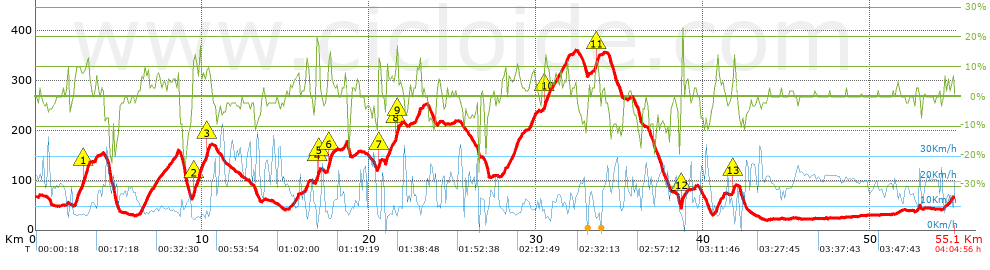
Distance in Km: 55.07
Climb in m: 1189
IBP: 85 BYC

Elzur Seve
Author: Elzur Seve
517 published routes

Add to my Group or Club

 Height in m      Climb in %      Speed in Km/h      Speed < 2 Km/h

Climbs > 5%

Climbs >5% Climbs >10% Climbs >15% Climbs >20% Climbs >25%
 Steep slope of 943 m.   Average slope  Distances  Download as waypoint
1
 Km 2.32  9%  571 m
2
 Km 2.891  11%  203 m
3
 Km 3.093  9%  169 m
 Steep slope of 161 m.  Average slope  Distances  Download as waypoint
4
 Km 3.565  6%  161 m
 Steep slope of 639 m.  Average slope  Distances  Download as waypoint
5
 Km 6.303  7%  639 m
 Steep slope of 245 m.  Average slope  Distances  Download as waypoint
6
 Km 7.058  6%  245 m
 Steep slope of 213 m.  Average slope  Distances  Download as waypoint
7
 Km 8.148  6%  213 m
 Steep slope of 106 m.  Average slope  Distances  Download as waypoint
8
 Km 8.457  8%  106 m
 Steep slope of 971 m.  Average slope  Distances  Download as waypoint
9
 Km 9.444  12%  391 m
10
 Km 9.835  9%  428 m
11
 Km 10.263  13%  108 m
12
 Km 10.371  5%  44 m
 Steep slope of 250 m.  Average slope  Distances  Download as waypoint
13
 Km 15.455  5%  250 m
 Steep slope of 189 m.  Average slope  Distances  Download as waypoint
14
 Km 16.189  10%  189 m
 Steep slope of 200 m.  Average slope  Distances  Download as waypoint
15
 Km 16.828  14%  101 m
16
 Km 16.929  17%  30 m
17
 Km 16.959  10%  69 m
 Steep slope of 342 m.  Average slope  Distances  Download as waypoint
18
 Km 17.459  8%  73 m
19
 Km 17.532  15%  161 m
20
 Km 17.694  6%  108 m
 Steep slope of 143 m.  Average slope  Distances  Download as waypoint
21
 Km 18.506  8%  143 m
 Steep slope of 165 m.  Average slope  Distances  Download as waypoint
22
 Km 20.492  9%  32 m
23
 Km 20.524  12%  133 m
 Steep slope of 699 m.  Average slope  Distances  Download as waypoint
24
 Km 20.973  8%  600 m
25
 Km 21.573  14%  70 m
26
 Km 21.643  17%  29 m
 Steep slope of 103 m.  Average slope  Distances  Download as waypoint
27
 Km 21.822  6%  103 m
 Steep slope of 317 m.  Average slope  Distances  Download as waypoint
28
 Km 22.769  9%  317 m
 Steep slope of 249 m.  Average slope  Distances  Download as waypoint
29
 Km 27.924  6%  249 m
 Steep slope of 758 m.  Average slope  Distances  Download as waypoint
30
 Km 28.307  8%  758 m
 Steep slope of 417 m.  Average slope  Distances  Download as waypoint
31
 Km 29.593  7%  417 m
 Steep slope of 406 m.  Average slope  Distances  Download as waypoint
32
 Km 30.418  7%  81 m
33
 Km 30.499  10%  134 m
34
 Km 30.633  10%  191 m
 Steep slope of 288 m.  Average slope  Distances  Download as waypoint
35
 Km 30.976  6%  288 m
 Steep slope of 481 m.  Average slope  Distances  Download as waypoint
36
 Km 31.392  7%  481 m
 Steep slope of 337 m.  Average slope  Distances  Download as waypoint
37
 Km 33.454  8%  65 m
38
 Km 33.519  12%  139 m
39
 Km 33.658  10%  133 m
 Steep slope of 130 m.  Average slope  Distances  Download as waypoint
40
 Km 38.663  9%  33 m
41
 Km 38.695  21%  97 m
 Steep slope of 459 m.  Average slope  Distances  Download as waypoint
42
 Km 40.704  7%  459 m
 Steep slope of 98 m.  Average slope  Distances  Download as waypoint
43
 Km 41.769  12%  98 m
 Steep slope of 117 m.  Average slope  Distances  Download as waypoint
44
 Km 52.795  5%  117 m


Description of the route


Presence of ramps


 Climbs  Distance  % of the total  Speed  Your speed would be  Time  Your time would be
   15 - 30%  0.429  0.78  5.61  ?  0:04:35  ?
   10 - 15%  2.379  4.32  7.6  ?  0:18:47  ?
   5 - 10%  7.575  13.76  9.44  ?  0:48:09  ?
   1 - 5%  10.244  18.6  13.99  ?  0:43:56  ?
   Total*  20.627 Km  37.46 %  10.72 Km/h  ? Km/h    1:55:27 h  ? h  
 Flat
   1 - -1%  15.224 Km  27.65 %  18.78 Km/h  ? Km/h    0:48:38 h  ? h  
 Descents
   -1 - -5%  10.218  18.56  21.56  ?  0:28:26  ?
   -5 - -10%  5.316  9.65  18.3  ?  0:17:26  ?
   -10 - -15%  2.545  4.62  16.16  ?  0:09:27  ?
   -15 - -30%  1.142  2.07  8.43  ?  0:08:08  ?
   Total*  19.221 Km  34.91 %  18.18 Km/h  ? Km/h    1:03:27 h  ? h  
* The total has not necessarily coincide with the sum of the partials after correction of errors

How long would it take you?

How long would it take you to cover this route?
There are routes without a valid time information, but with your average stats you can assess the possible duration

Elzur Seve to cover this route you've need a time of:   3:47:32 h 
If you sign in and have a minimum of two tracks of this same modality, you can know your time for this route, calculated from your stats..


¿Cuanto consumirá tu E-BIKE?

Entra tu E-IBP (formato n,nn)

E-IBP :   X 85 = 


 Detected activity type =  ()
 Penalization due to track conditions: 58 %   ( > 50 % = MTB, < 50 % = RDB)
 Reliability of the track: A   (1189/81/0/-/-/81)
 Correction level applied to the track: 0
DIFFICULTY OF THE ROUTE
IBP = 85 BYC
According to your statistics
 Your time in motion would be: ? h
Your average speed would be: ? Km/h
 

 Total Distance: 55.07 Km
 Analysed distance: 55.07 Km
 Linear distance: 0.39 Km

 Cumulated positive ramps: 1189 m  list of points info
 Cumulated negative ramps: 1190 m
 Maximum height: 361 m
 Minimum height: 20 m
 Climbing Ratio: 5.76 %
 Descent ratio: 6.19 %
 Cumulated postive ramps per Km: 21.59 m
 Cumulated negative ramps per Km: 21.61 m

 Total time: 4:04:56 h
 Time in movement: 3:47:32 h
 According to your statistics
 Your time in motion would be: ? h  
 Stopped time: 0:17:24 h
 Maximum slope filter: ~30 %
 Minimum separation analysed: ~30 m
 Number of points: 2967   (cad. 18.56 m)
 Significant waypoints: 1356   (cad. 40.64 m / 45.7 %)

 Changes in direction per Km: 11.31
 Changes in direction > 5º por Km: 8.59
 Cumulated straight stretches: 8.983 Km
 Straight stretches per Km: 163.12 m
 Penalized slope changes: 15
 Penalized slope changes per Km: 0.272

 Average speed in total: 13.49 Km/h
 Average speed while moving: 14.52 Km/h
 According to your statistics
 Your average speed would be: ? Km/h  
 Maximum sustained speed: 44.83 Km/h


Comments

You can be the first one in commenting this route

 
My comments
:
Add comment  (Registered users)
 
Notify me answers to my comment  Do not notify answers to my comment


Share this route with a friend

Your friend will receive a message with a link to this page:
will see your email and your user name if you do it as registered user.


Write here your name (optional)

E-mail address of your friend(s). You can include various addresses separated by commas

Text or comment (optional) maximum 255 characters long, 255 Available characters

As a non registered users you need to fill-in the captcha text.
  Change image
Type the image characters.
 
 Share with a friend


Visited history

Delete history

Marked routes for review later or compare

My favorites


  Notify anomaly in this route Share in Facebook