Lliria-Altura-Alcublas-Lliria (02/14)

Road
Road
Ref..: 24818
Published: 08/05/2015
Performed: 22/02/2014
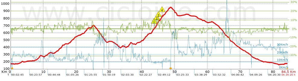
Distance in Km: 84.4
Climb in m: 1317
IBP: 81 BYC

delfinpascual
252 published routes

Add to my Group or Club

 Height in m      Climb in %      Speed in Km/h      Speed < 2 Km/h

Climbs > 5%

Climbs >5% Climbs >10% Climbs >15% Climbs >20% Climbs >25%
 Steep slope of 520 m.   Average slope  Distances  Download as waypoint
1
 Km 8.585  6%  520 m
 Steep slope of 176 m.  Average slope  Distances  Download as waypoint
2
 Km 11.274  6%  176 m
 Steep slope of 493 m.  Average slope  Distances  Download as waypoint
3
 Km 14.394  6%  493 m
 Steep slope of 528 m.  Average slope  Distances  Download as waypoint
4
 Km 15.364  7%  528 m
 Steep slope of 222 m.  Average slope  Distances  Download as waypoint
5
 Km 18.111  5%  222 m
 Steep slope of 269 m.  Average slope  Distances  Download as waypoint
6
 Km 19.318  6%  269 m
 Steep slope of 182 m.  Average slope  Distances  Download as waypoint
7
 Km 21.339  5%  182 m
 Steep slope of 526 m.  Average slope  Distances  Download as waypoint
8
 Km 22.513  6%  526 m
 Steep slope of 266 m.  Average slope  Distances  Download as waypoint
9
 Km 23.17  7%  266 m
 Steep slope of 441 m.  Average slope  Distances  Download as waypoint
10
 Km 24.744  6%  441 m
 Steep slope of 603 m.  Average slope  Distances  Download as waypoint
11
 Km 36.019  7%  603 m
 Steep slope of 218 m.  Average slope  Distances  Download as waypoint
12
 Km 38.332  5%  218 m
 Steep slope of 644 m.  Average slope  Distances  Download as waypoint
13
 Km 40.447  7%  644 m
 Steep slope of 130 m.  Average slope  Distances  Download as waypoint
14
 Km 41.221  5%  130 m
 Steep slope of 261 m.  Average slope  Distances  Download as waypoint
15
 Km 41.651  6%  261 m
 Steep slope of 953 m.  Average slope  Distances  Download as waypoint
16
 Km 42.877  7%  867 m
17
 Km 43.744  10%  86 m
 Steep slope of 782 m.  Average slope  Distances  Download as waypoint
18
 Km 44.042  8%  477 m
19
 Km 44.52  11%  260 m
20
 Km 44.78  8%  45 m
 Steep slope of 175 m.  Average slope  Distances  Download as waypoint
21
 Km 45.038  9%  44 m
22
 Km 45.083  12%  131 m
 Steep slope of 690 m.  Average slope  Distances  Download as waypoint
23
 Km 45.595  7%  517 m
24
 Km 46.111  15%  132 m
25
 Km 46.243  7%  41 m
 Steep slope of 216 m.  Average slope  Distances  Download as waypoint
26
 Km 46.501  6%  216 m
 Steep slope of 398 m.  Average slope  Distances  Download as waypoint
27
 Km 47.03  8%  398 m
 Steep slope of 575 m.  Average slope  Distances  Download as waypoint
28
 Km 47.779  7%  575 m
 Steep slope of 134 m.  Average slope  Distances  Download as waypoint
29
 Km 48.484  7%  134 m


Description of the route


Presence of ramps


 Climbs  Distance  % of the total  Speed  Your speed would be  Time  Your time would be
   15 - 30%  0.087  0.1  26.21  ?  0:00:12  ?
   10 - 15%  0.654  0.77  11.31  ?  0:03:28  ?
   5 - 10%  9.105  10.79  12.86  ?  0:42:29  ?
   1 - 5%  22.422  26.57  16.58  ?  1:21:07  ?
   Total*  32.268 Km  38.23 %  15.21 Km/h  ? Km/h    2:07:16 h  ? h  
 Flat
   1 - -1%  14.285 Km  16.93 %  22.08 Km/h  ? Km/h    0:38:49 h  ? h  
 Descents
   -1 - -5%  31.571  37.41  28.69  ?  1:06:01  ?
   -5 - -10%  5.604  6.64  33.02  ?  0:10:11  ?
   -10 - -15%  0.738  0.87  44.28  ?  0:01:00  ?
   -15 - -30%  0  0  0  ?  0:00:00  ?
   Total*  37.913 Km  44.92 %  29.47 Km/h  ? Km/h    1:17:12 h  ? h  
* The total has not necessarily coincide with the sum of the partials after correction of errors

How long would it take you?

How long would it take you to cover this route?
There are routes without a valid time information, but with your average stats you can assess the possible duration

delfinpascual to cover this route you've need a time of:   4:03:17 h 
If you sign in and have a minimum of two tracks of this same modality, you can know your time for this route, calculated from your stats..


¿Cuanto consumirá tu E-BIKE?

Entra tu E-IBP (formato n,nn)

E-IBP :   X 81 = 


 Detected activity type =  ()
 Penalization due to track conditions: 41 %   ( > 50 % = MTB, < 50 % = RDB)
 Reliability of the track: D   (1507/48/1/8/-/67)
 Correction level applied to the track: 2        See analyis without corrections
DIFFICULTY OF THE ROUTE
IBP = 81 BYC
According to your statistics
 Your time in motion would be: ? h
Your average speed would be: ? Km/h
 

 Total Distance: 84.4 Km
 Analysed distance: 84.4 Km
 Linear distance: 0 Km

 Cumulated positive ramps: 1316.6 m  list of points info
 Cumulated negative ramps: 1307.65 m
 Maximum height: 953.59 m
 Minimum height: 158.33 m
 Climbing Ratio: 4.08 %
 Descent ratio: 3.45 %
 Cumulated postive ramps per Km: 15.6 m
 Cumulated negative ramps per Km: 15.49 m

 Total time: 4:34:25 h
 Time in movement: 4:03:17 h
 According to your statistics
 Your time in motion would be: ? h  
 Stopped time: 0:31:08 h
 Maximum slope filter: ~30 %
 Minimum separation analysed: ~30 m
 Number of points: 3557   (cad. 23.73 m)
 Significant waypoints: 1830   (cad. 46.15 m / 51.45 %)

 Changes in direction per Km: 9.18
 Changes in direction > 5º por Km: 5.04
 Cumulated straight stretches: 18.719 Km
 Straight stretches per Km: 221.79 m
 Penalized slope changes: 10
 Penalized slope changes per Km: 0.118

 Average speed in total: 18.45 Km/h
 Average speed while moving: 20.82 Km/h
 According to your statistics
 Your average speed would be: ? Km/h  
 Maximum sustained speed: 66.73 Km/h


Comments

You can be the first one in commenting this route

 
My comments
:
Add comment  (Registered users)
 
Notify me answers to my comment  Do not notify answers to my comment


Share this route with a friend

Your friend will receive a message with a link to this page:
will see your email and your user name if you do it as registered user.


Write here your name (optional)

E-mail address of your friend(s). You can include various addresses separated by commas

Text or comment (optional) maximum 255 characters long, 255 Available characters

As a non registered users you need to fill-in the captcha text.
  Change image
Type the image characters.
 
 Share with a friend


Visited history

Delete history

Marked routes for review later or compare

My favorites


  Notify anomaly in this route Share in Facebook