Una local_

MTB
MTB
Ref..: 1147872
Published: 26/04/2024
Performed: 26/04/2024
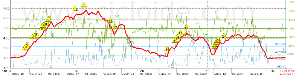
Distance in Km: 41.93
Climb in m: 1446
IBP: 124 BYC

Near ...
Andarujo, Artosa (Langreo), Barraca, La (Ciaño-Langreo), Barraca, La (Langreo), Barripies, Barros
Eduluna
Author: Eduluna
428 published routes

Add to my Group or Club

 Height in m      Climb in %      Speed in Km/h      Speed < 2 Km/h

Climbs > 10%

Climbs >5% Climbs >10% Climbs >15% Climbs >20% Climbs >25%
 Steep slope of 527 m.   Average slope  Distances  Download as waypoint
1
 Km 2.169  11%  166 m
2
 Km 2.336  11%  133 m
3
 Km 2.468  12%  228 m
4
 Km 3.381  15%  133 m
 Steep slope of 367 m.  Average slope  Distances  Download as waypoint
5
 Km 3.857  10%  101 m
6
 Km 4.799  13%  133 m
7
 Km 4.932  18%  133 m
 Steep slope of 479 m.  Average slope  Distances  Download as waypoint
8
 Km 5.373  14%  193 m
9
 Km 5.764  13%  286 m
 Steep slope of 97 m.  Average slope  Distances  Download as waypoint
10
 Km 9.734  13%  97 m
 Steep slope of 100 m.  Average slope  Distances  Download as waypoint
11
 Km 11.133  19%  100 m
 Steep slope of 135 m.  Average slope  Distances  Download as waypoint
12
 Km 15.166  17%  109 m
 Steep slope of 641 m.  Average slope  Distances  Download as waypoint
13
 Km 15.839  14%  641 m
 Steep slope of 281 m.  Average slope  Distances  Download as waypoint
14
 Km 23.873  20%  281 m
 Steep slope of 538 m.  Average slope  Distances  Download as waypoint
15
 Km 25.056  12%  229 m
16
 Km 25.381  10%  137 m
17
 Km 25.876  17%  172 m
 Steep slope of 99 m.  Average slope  Distances  Download as waypoint
18
 Km 26.724  19%  99 m
 Steep slope of 652 m.  Average slope  Distances  Download as waypoint
19
 Km 31.035  11%  31 m
20
 Km 31.066  18%  205 m
21
 Km 31.271  11%  160 m
22
 Km 31.431  12%  97 m
23
 Km 31.529  13%  256 m
 Steep slope of 200 m.  Average slope  Distances  Download as waypoint
24
 Km 32.51  12%  200 m


Description of the route


Presence of ramps


 Climbs  Distance  % of the total  Speed  Your speed would be  Time  Your time would be
   15 - 30%  1.496  3.57  5.28  ?  0:16:59  ?
   10 - 15%  3.629  8.65  6.6  ?  0:32:58  ?
   5 - 10%  7.252  17.3  9.21  ?  0:47:14  ?
   1 - 5%  5.997  14.3  11.99  ?  0:30:01  ?
   Total*  18.374 Km  43.82 %  8.67 Km/h  ? Km/h    2:07:12 h  ? h  
 Flat
   1 - -1%  6.76 Km  16.12 %  15.65 Km/h  ? Km/h    0:25:55 h  ? h  
 Descents
   -1 - -5%  6.815  16.25  17.07  ?  0:23:57  ?
   -5 - -10%  4.385  10.46  20.66  ?  0:12:44  ?
   -10 - -15%  2.761  6.58  25.55  ?  0:06:29  ?
   -15 - -30%  2.836  6.76  18.04  ?  0:09:26  ?
   Total*  16.797 Km  40.06 %  19.16 Km/h  ? Km/h    0:52:36 h  ? h  
* The total has not necessarily coincide with the sum of the partials after correction of errors

How long would it take you?

How long would it take you to cover this route?
There are routes without a valid time information, but with your average stats you can assess the possible duration

Eduluna to cover this route you've need a time of:   3:25:43 h 
If you sign in and have a minimum of two tracks of this same modality, you can know your time for this route, calculated from your stats..


¿Cuanto consumirá tu E-BIKE?

Entra tu E-IBP (formato n,nn)

E-IBP :   X 124 = 


 Detected activity type =  ()
 Penalization due to track conditions: 76 %   ( > 50 % = MTB, < 50 % = RDB)
 Reliability of the track: B   (1444/63/0/-/-/63)
 Correction level applied to the track: 0
DIFFICULTY OF THE ROUTE
IBP = 124 BYC
According to your statistics
 Your time in motion would be: ? h
Your average speed would be: ? Km/h
 

 Total Distance: 41.93 Km
 Analysed distance: 41.93 Km
 Linear distance: 0.13 Km

 Cumulated positive ramps: 1445.72 m  list of points info
 Cumulated negative ramps: 1450.02 m
 Maximum height: 682.9 m
 Minimum height: 197.3 m
 Climbing Ratio: 7.87 %
 Descent ratio: 8.63 %
 Cumulated postive ramps per Km: 34.48 m
 Cumulated negative ramps per Km: 34.58 m

 Total time: 3:34:26 h
 Time in movement: 3:25:43 h
 According to your statistics
 Your time in motion would be: ? h  
 Stopped time: 0:08:43 h
 Maximum slope filter: ~30 %
 Minimum separation analysed: ~30 m
 Number of points: 3404   (cad. 12.32 m)
 Significant waypoints: 1183   (cad. 35.44 m / 34.75 %)

 Changes in direction per Km: 12.07
 Changes in direction > 5º por Km: 9.25
 Cumulated straight stretches: 5.465 Km
 Straight stretches per Km: 130.34 m
 Penalized slope changes: 15
 Penalized slope changes per Km: 0.358

 Average speed in total: 11.73 Km/h
 Average speed while moving: 12.23 Km/h
 According to your statistics
 Your average speed would be: ? Km/h  
 Maximum sustained speed: 49.51 Km/h


Comments

You can be the first one in commenting this route

 
My comments
:
Add comment  (Registered users)
 
Notify me answers to my comment  Do not notify answers to my comment


Share this route with a friend

Your friend will receive a message with a link to this page:
will see your email and your user name if you do it as registered user.


Write here your name (optional)

E-mail address of your friend(s). You can include various addresses separated by commas

Text or comment (optional) maximum 255 characters long, 255 Available characters

As a non registered users you need to fill-in the captcha text.
  Change image
Type the image characters.
 
 Share with a friend


Visited history

Delete history

Marked routes for review later or compare

My favorites


  Notify anomaly in this route Share in Facebook