A CASTRELADA

MTB
MTB
Ref..: 1147119
Published: 21/04/2024
Performed: 21/04/2024
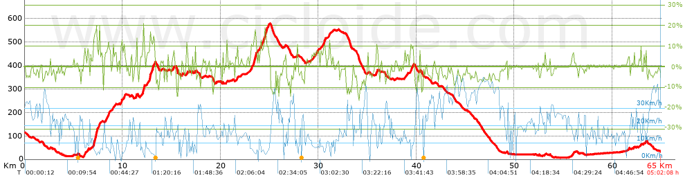
Distance in Km: 65.01
Climb in m: 1245
IBP: 106 BYC

Near ...
Acevedo (Ponte Sampaio), Aranza (Soutomaior), Arcade (Santiago), Bretoña (Curro), Calle, A (Arcade), Canicouva, A (Santo Estevo)
Javier Durán
299 published routes

Add to my Group or Club

 Height in m      Climb in %      Speed in Km/h      Speed < 2 Km/h

Climbs > 5%

Climbs >5% Climbs >10% Climbs >15% Climbs >20% Climbs >25%
 Steep slope of 247 m.   Average slope  Distances  Download as waypoint
1
 Km 6.013  8%  247 m
 Steep slope of 192 m.  Average slope  Distances  Download as waypoint
2
 Km 6.393  7%  192 m
 Steep slope of 618 m.  Average slope  Distances  Download as waypoint
3
 Km 7.008  13%  47 m
4
 Km 7.055  18%  310 m
5
 Km 7.365  17%  72 m
6
 Km 7.437  8%  189 m
 Steep slope of 537 m.  Average slope  Distances  Download as waypoint
7
 Km 8.228  8%  537 m
 Steep slope of 185 m.  Average slope  Distances  Download as waypoint
8
 Km 8.893  7%  185 m
 Steep slope of 138 m.  Average slope  Distances  Download as waypoint
9
 Km 9.224  6%  138 m
 Steep slope of 149 m.  Average slope  Distances  Download as waypoint
10
 Km 9.815  12%  149 m
 Steep slope of 62 m.  Average slope  Distances  Download as waypoint
11
 Km 10.119  12%  62 m
 Steep slope of 131 m.  Average slope  Distances  Download as waypoint
12
 Km 11.377  13%  99 m
13
 Km 11.476  10%  32 m
 Steep slope of 463 m.  Average slope  Distances  Download as waypoint
14
 Km 11.784  6%  281 m
15
 Km 12.065  11%  39 m
16
 Km 12.104  20%  105 m
17
 Km 12.209  13%  38 m
 Steep slope of 860 m.  Average slope  Distances  Download as waypoint
18
 Km 12.427  7%  334 m
19
 Km 12.76  20%  116 m
20
 Km 12.876  10%  197 m
21
 Km 13.073  16%  147 m
22
 Km 13.221  13%  37 m
23
 Km 13.258  11%  29 m
 Steep slope of 201 m.  Average slope  Distances  Download as waypoint
24
 Km 15.117  7%  201 m
 Steep slope of 189 m.  Average slope  Distances  Download as waypoint
25
 Km 16.515  8%  189 m
 Steep slope of 101 m.  Average slope  Distances  Download as waypoint
26
 Km 17.39  9%  101 m
 Steep slope of 188 m.  Average slope  Distances  Download as waypoint
27
 Km 21.58  7%  188 m
 Steep slope of 741 m.  Average slope  Distances  Download as waypoint
28
 Km 23.048  6%  83 m
29
 Km 23.132  10%  219 m
30
 Km 23.35  16%  211 m
31
 Km 23.561  17%  72 m
32
 Km 23.633  7%  156 m
 Steep slope of 860 m.  Average slope  Distances  Download as waypoint
33
 Km 24.026  7%  57 m
34
 Km 24.083  12%  153 m
35
 Km 24.236  7%  135 m
36
 Km 24.371  11%  115 m
37
 Km 24.487  16%  192 m
38
 Km 24.678  18%  33 m
39
 Km 24.711  11%  175 m
 Steep slope of 720 m.  Average slope  Distances  Download as waypoint
40
 Km 29.343  6%  720 m
 Steep slope of 499 m.  Average slope  Distances  Download as waypoint
41
 Km 30.249  7%  271 m
42
 Km 30.521  11%  192 m
43
 Km 30.713  9%  36 m
 Steep slope of 159 m.  Average slope  Distances  Download as waypoint
44
 Km 31.098  9%  159 m
 Steep slope of 191 m.  Average slope  Distances  Download as waypoint
45
 Km 35.9  10%  191 m
 Steep slope of 126 m.  Average slope  Distances  Download as waypoint
46
 Km 38.761  8%  126 m
 Steep slope of 172 m.  Average slope  Distances  Download as waypoint
47
 Km 38.999  7%  172 m
 Steep slope of 421 m.  Average slope  Distances  Download as waypoint
48
 Km 39.323  6%  87 m
49
 Km 39.41  11%  174 m
50
 Km 39.585  8%  160 m
 Steep slope of 101 m.  Average slope  Distances  Download as waypoint
51
 Km 40.34  8%  101 m
 Steep slope of 122 m.  Average slope  Distances  Download as waypoint
52
 Km 53.11  6%  122 m
 Steep slope of 219 m.  Average slope  Distances  Download as waypoint
53
 Km 55.928  6%  219 m
 Steep slope of 100 m.  Average slope  Distances  Download as waypoint
54
 Km 62.889  8%  100 m


Description of the route


Presence of ramps


 Climbs  Distance  % of the total  Speed  Your speed would be  Time  Your time would be
   15 - 30%  1.14  1.75  5.21  ?  0:13:08  ?
   10 - 15%  2.514  3.87  6.2  ?  0:24:21  ?
   5 - 10%  6.569  10.1  8.81  ?  0:44:45  ?
   1 - 5%  11.005  16.93  12.96  ?  0:50:58  ?
   Total*  21.228 Km  32.65 %  9.56 Km/h  ? Km/h    2:13:12 h  ? h  
 Flat
   1 - -1%  16.555 Km  25.47 %  16.72 Km/h  ? Km/h    0:59:25 h  ? h  
 Descents
   -1 - -5%  15.944  24.53  21.65  ?  0:44:11  ?
   -5 - -10%  8.92  13.72  24.99  ?  0:21:25  ?
   -10 - -15%  2.26  3.48  24.58  ?  0:05:31  ?
   -15 - -30%  0.102  0.16  18.45  ?  0:00:20  ?
   Total*  27.227 Km  41.88 %  22.86 Km/h  ? Km/h    1:11:27 h  ? h  
* The total has not necessarily coincide with the sum of the partials after correction of errors

How long would it take you?

How long would it take you to cover this route?
There are routes without a valid time information, but with your average stats you can assess the possible duration

Javier Durán to cover this route you've need a time of:   4:24:04 h 
If you sign in and have a minimum of two tracks of this same modality, you can know your time for this route, calculated from your stats..


¿Cuanto consumirá tu E-BIKE?

Entra tu E-IBP (formato n,nn)

E-IBP :   X 106 = 


 Detected activity type =  ()
 Penalization due to track conditions: 70 %   ( > 50 % = MTB, < 50 % = RDB)
 Reliability of the track: B   (1245/62/0/-/-/62)
 Correction level applied to the track: 0
DIFFICULTY OF THE ROUTE
IBP = 106 BYC
According to your statistics
 Your time in motion would be: ? h
Your average speed would be: ? Km/h
 

 Total Distance: 65.01 Km
 Analysed distance: 65.01 Km
 Linear distance: 5.9 Km

 Cumulated positive ramps: 1244.9 m  list of points info
 Cumulated negative ramps: 1341.9 m
 Maximum height: 578.2 m
 Minimum height: 6.6 m
 Climbing Ratio: 5.86 %
 Descent ratio: 4.93 %
 Cumulated postive ramps per Km: 19.15 m
 Cumulated negative ramps per Km: 20.64 m

 Total time: 5:02:08 h
 Time in movement: 4:24:04 h
 According to your statistics
 Your time in motion would be: ? h  
 Stopped time: 0:38:04 h
 Maximum slope filter: ~30 %
 Minimum separation analysed: ~30 m
 Number of points: 3295   (cad. 19.73 m)
 Significant waypoints: 1595   (cad. 40.76 m / 48.41 %)

 Changes in direction per Km: 9.63
 Changes in direction > 5º por Km: 7.48
 Cumulated straight stretches: 12.28 Km
 Straight stretches per Km: 188.89 m
 Penalized slope changes: 12
 Penalized slope changes per Km: 0.185

 Average speed in total: 12.91 Km/h
 Average speed while moving: 14.77 Km/h
 According to your statistics
 Your average speed would be: ? Km/h  
 Maximum sustained speed: 50.53 Km/h


Comments

You can be the first one in commenting this route

 
My comments
:
Add comment  (Registered users)
 
Notify me answers to my comment  Do not notify answers to my comment


Share this route with a friend

Your friend will receive a message with a link to this page:
will see your email and your user name if you do it as registered user.


Write here your name (optional)

E-mail address of your friend(s). You can include various addresses separated by commas

Text or comment (optional) maximum 255 characters long, 255 Available characters

As a non registered users you need to fill-in the captcha text.
  Change image
Type the image characters.
 
 Share with a friend


Visited history

Delete history

Marked routes for review later or compare

My favorites


  Notify anomaly in this route Share in Facebook