378.Circular Presa de los Lindes-Cascadas y Chorrera de Rovellanos-Presa del Batán desde Canencia

Hiking
Hiking
Ref..: 1146204
Published: 14/04/2024
Performed: 28/01/2024
Distance in Km: 16.45
Climb in m: 672
IBP: 71 HKG

Carlos Plaza Esteban
260 published routes

Add to my Group or Club

 Height in m      Climb in %      Speed in Km/h      Speed < 2 Km/h


Description of the route

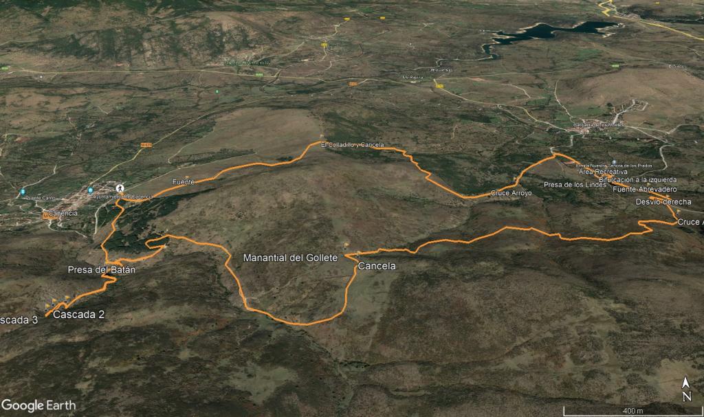
DESCRIPCIÓN DEL ITINERARIO
Ruta circular desde Canencia pasando por:
- El Colladillo (2.1 km)
- Embalse de los Lindes (6.7 km)
- Mirador de los Helechares (7.3 km)
- Manantial del Gollete (10.5 km)
- Chorrera de Rovellanos (14.2 km)
- Presa del Batán (14.8 km)
- Mirador de Canencia (15.4 km)

DISTANCIA: 16,45 km.
TIEMPO: 6 h. 19 min. (4 h. 37 min. en movimiento con paradas).
VELOCIDAD MEDIA: 2,6 km/h. con paradas.
DESNIVEL SUBIDO: 672,5 metros.
DESNIVEL BAJADO: 678,4 metros.
RATIO DE SUBIDA: 8,47 %/km.
RATIO DE BAJADA: 8,41 %/km.
DESNIVEL POSITIVO POR KM: 40,88 metros.
DESNIVEL NEGATIVO POR KM: 41,24 metros.
DIFICULTAD: Fácil.
MATERIAL: Senderismo.
TIPO DE RUTA: Circular.
TERRENO: Pista, senderos, senderos con hitos y campo a través.
INDICE DE ESFUERZO: 71 HKG. MEDIA. (Condición Física Media).

Salimos en dirección al Helipuerto que pasamos unos metros más arriba girando a la izquierda y siguiendo un sendero-pista, iremos ascendiendo suavemente pasando por una fuente, llegando al Colladito y atravesando una cancela, después bajamos y poco, giramos a la derecha cogiendo otro sendero, cruzamos un arroyo y seguiremos nuestro sendero-pista hasta unas fincas las cuales bordeamos a la derecha cogiendo una ancha pista que nos lleva hasta la Presa de Lindes pero antes nos desviamos a la izquierda en dirección a la Ermita de Nuestra Señora de los Prados (sin llegar a ella) nos disponemos a almorzar en un Area Recreativa con unas mesas y bancos de madera. Después del tentempié cogemos el camino de la derecha dejando la presa de los Lindes a mano derecha y ascendiendo suavemente por la pista unos 200 metros antes de desviarnos a mano derecha cogiendo un sendero poco definido pero que se intuye bien, cruzamos un arroyo y unos metros más adelante empezamos a realizar un campo a través (tengo que decir que el camino en realidad discurre paralelo con unas marcas o palos con una vaquita dibujada y con flechas, sino quieres seguir el track mejor seguir este camino), vamos buscando el mejor camino a veces nos encontramos con pequeños senderos hechos por los animales, vamos avanzando cómodamente y por el camino más sencillo subiendo paralelo al Arroyo de Orbiduero hasta el Manantial de Goyete.

Aquí giramos a la derecha cruzando más adelante una cancela a mano derecha y seguiremos un senderito pegado al murete que separan unas cuantas fincas para más adelante coger una pista a mano derecha avanzando por ella durante casi 3 km y descendiendo suavemente en dirección a Canencia, encontramos una bifurcación a la izquierda por la que bajaremos a la Presa del Batán, que cruzamos unos metros más abajo y seguir un sendero marcado con hitos que nos hará ascender paralelo al Arroyo Matallana durante 1 km hasta una sucesión de pequeñas cascadas y a la Chorrera de Rovellanos, después de deleitarnos con las fotos volvemos por el mismo sitio, volvemos a cruzar la Presa del Batán y enlazamos nuevamente con nuestra pista de antes descendiendo hasta Canencia teniendo una vista muy chula del pueblo a mano izquierda seguiremos por esta pista hasta los coches.

Nos vemos en las Montañas!!.


Imagen de la ruta


Presence of ramps


 Climbs  Distance  % of the total  Speed  Your speed would be  Time  Your time would be
   15 - 30%  1.037  6.3  2.58  ?  0:24:08  ?
   10 - 15%  1.013  6.16  3.39  ?  0:17:56  ?
   5 - 10%  4.042  24.57  3.75  ?  1:04:42  ?
   1 - 5%  1.797  10.92  3.15  ?  0:34:12  ?
   Total*  7.944 Km  48.29 %  3.35 Km/h  ? Km/h    2:22:11 h  ? h  
 Flat
   1 - -1%  0.442 Km  2.69 %  4.12 Km/h  ? Km/h    0:06:26 h  ? h  
 Descents
   -1 - -5%  2.424  14.73  3.93  ?  0:36:58  ?
   -5 - -10%  3.345  20.34  4.35  ?  0:46:10  ?
   -10 - -15%  1.225  7.44  2.83  ?  0:25:58  ?
   -15 - -30%  0.967  5.88  3.41  ?  0:17:02  ?
   Total*  8.065 Km  49.02 %  3.75 Km/h  ? Km/h    2:08:59 h  ? h  
* The total has not necessarily coincide with the sum of the partials after correction of errors

How long would it take you?

How long would it take you to cover this route?
There are routes without a valid time information, but with your average stats you can assess the possible duration

Carlos Plaza Esteban to cover this route you've need a time of:   4:37:36 h 
If you sign in and have a minimum of two tracks of this same modality, you can know your time for this route, calculated from your stats..


 Detected activity type =  ()
 Penalization due to track conditions: 0 %   ( > 50 % = MTB, < 50 % = RDB)
 Reliability of the track: A   (672/96/0/-/-/96)
 Correction level applied to the track: 0
DIFFICULTY OF THE ROUTE
IBP = 71 HKG
According to your statistics
 Your time in motion would be: ? h
Your average speed would be: ? Km/h
 

 Total Distance: 16.45 Km
 Analysed distance: 16.45 Km
 Linear distance: 0.01 Km

 Cumulated positive ramps: 672.36 m  list of points info
 Cumulated negative ramps: 678.39 m
 Maximum height: 1416.28 m
 Minimum height: 1164.45 m
 Climbing Ratio: 8.46 %
 Descent ratio: 8.41 %
 Cumulated postive ramps per Km: 40.87 m
 Cumulated negative ramps per Km: 41.24 m

 Total time: 6:19:17 h
 Time in movement: 4:37:36 h
 According to your statistics
 Your time in motion would be: ? h  
 Stopped time: 1:41:41 h
 Maximum slope filter: ~55 %
 Minimum separation analysed: ~30 m
 Number of points: 205   (cad. 80.25 m)
 Significant waypoints: 185   (cad. 88.92 m / 90.24 %)

 Changes in direction per Km: 6.87
 Changes in direction > 5º por Km: 6.87
 Cumulated straight stretches: 0 Km
 Straight stretches per Km: 0 m
 Penalized slope changes: 9
 Penalized slope changes per Km: 0.547

 Average speed in total: 2.6 Km/h
 Average speed while moving: 3.56 Km/h
 According to your statistics
 Your average speed would be: ? Km/h  
 Maximum sustained speed: 5.39 Km/h


Comments

You can be the first one in commenting this route

 
My comments
:
Add comment  (Registered users)
 
Notify me answers to my comment  Do not notify answers to my comment


Share this route with a friend

Your friend will receive a message with a link to this page:
will see your email and your user name if you do it as registered user.


Write here your name (optional)

E-mail address of your friend(s). You can include various addresses separated by commas

Text or comment (optional) maximum 255 characters long, 255 Available characters

As a non registered users you need to fill-in the captcha text.
  Change image
Type the image characters.
 
 Share with a friend


Visited history

Delete history

Marked routes for review later or compare

My favorites


  Notify anomaly in this route Share in Facebook