Visita a la ermita del Remei y de paso la de Sant Ramón __

MTB
MTB
Ref..: 1145158
Published: 08/04/2024
Performed: 07/04/2024
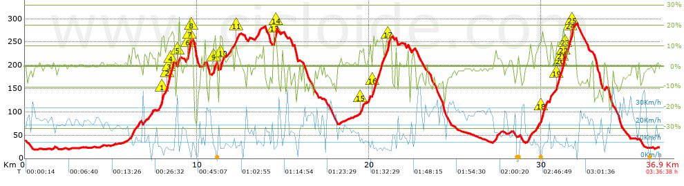
Distance in Km: 36.93
Climb in m: 1014
IBP: 96 BYC

Autor 26486
Author: Autor 26486
314 published routes

Add to my Group or Club

 Height in m      Climb in %      Speed in Km/h      Speed < 2 Km/h

Climbs > 5%

Climbs >5% Climbs >10% Climbs >15% Climbs >20% Climbs >25%
 Steep slope of 206 m.   Average slope  Distances  Download as waypoint
1
 Km 6.202  8%  206 m
 Steep slope of 173 m.  Average slope  Distances  Download as waypoint
2
 Km 6.514  6%  173 m
 Steep slope of 101 m.  Average slope  Distances  Download as waypoint
3
 Km 6.946  6%  101 m
 Steep slope of 198 m.  Average slope  Distances  Download as waypoint
4
 Km 7.213  6%  198 m
 Steep slope of 646 m.  Average slope  Distances  Download as waypoint
5
 Km 7.744  6%  197 m
6
 Km 7.941  15%  142 m
7
 Km 8.083  8%  138 m
8
 Km 8.221  12%  133 m
9
 Km 8.354  16%  36 m
 Steep slope of 235 m.  Average slope  Distances  Download as waypoint
10
 Km 8.491  15%  135 m
11
 Km 8.626  10%  100 m
 Steep slope of 104 m.  Average slope  Distances  Download as waypoint
12
 Km 8.908  17%  104 m
 Steep slope of 335 m.  Average slope  Distances  Download as waypoint
13
 Km 9.365  7%  143 m
14
 Km 9.508  16%  33 m
15
 Km 9.54  21%  100 m
16
 Km 9.64  19%  59 m
 Steep slope of 102 m.  Average slope  Distances  Download as waypoint
17
 Km 10.405  11%  102 m
 Steep slope of 200 m.  Average slope  Distances  Download as waypoint
18
 Km 10.943  10%  69 m
19
 Km 11.012  14%  131 m
 Steep slope of 239 m.  Average slope  Distances  Download as waypoint
20
 Km 11.32  13%  205 m
21
 Km 11.525  6%  34 m
 Steep slope of 274 m.  Average slope  Distances  Download as waypoint
22
 Km 11.824  6%  274 m
 Steep slope of 235 m.  Average slope  Distances  Download as waypoint
23
 Km 12.199  9%  35 m
24
 Km 12.234  11%  100 m
25
 Km 12.334  8%  100 m
 Steep slope of 101 m.  Average slope  Distances  Download as waypoint
26
 Km 13.565  11%  101 m
 Steep slope of 236 m.  Average slope  Distances  Download as waypoint
27
 Km 14.443  14%  32 m
28
 Km 14.476  17%  135 m
29
 Km 14.611  22%  33 m
30
 Km 14.644  6%  36 m
 Steep slope of 208 m.  Average slope  Distances  Download as waypoint
31
 Km 19.446  8%  33 m
32
 Km 19.479  10%  103 m
33
 Km 19.582  12%  72 m
 Steep slope of 141 m.  Average slope  Distances  Download as waypoint
34
 Km 19.889  7%  141 m
 Steep slope of 1112 m.  Average slope  Distances  Download as waypoint
35
 Km 20.202  12%  544 m
36
 Km 20.746  9%  299 m
37
 Km 21.045  18%  131 m
38
 Km 21.176  7%  67 m
39
 Km 21.242  14%  71 m
 Steep slope of 123 m.  Average slope  Distances  Download as waypoint
40
 Km 27.321  8%  123 m
 Steep slope of 168 m.  Average slope  Distances  Download as waypoint
41
 Km 29.276  7%  168 m
 Steep slope of 173 m.  Average slope  Distances  Download as waypoint
42
 Km 29.644  6%  173 m
 Steep slope of 420 m.  Average slope  Distances  Download as waypoint
43
 Km 29.92  10%  66 m
44
 Km 29.986  12%  240 m
45
 Km 30.226  9%  114 m
 Steep slope of 203 m.  Average slope  Distances  Download as waypoint
46
 Km 30.454  9%  203 m
 Steep slope of 1103 m.  Average slope  Distances  Download as waypoint
47
 Km 30.83  9%  34 m
48
 Km 30.863  12%  242 m
49
 Km 31.105  10%  99 m
50
 Km 31.204  13%  35 m
51
 Km 31.239  17%  130 m
52
 Km 31.369  11%  281 m
53
 Km 31.649  18%  139 m
54
 Km 31.788  17%  38 m
55
 Km 31.826  9%  105 m


Description of the route


Presence of ramps


 Climbs  Distance  % of the total  Speed  Your speed would be  Time  Your time would be
   15 - 30%  1.35  3.66  6.9  ?  0:11:45  ?
   10 - 15%  2.607  7.06  8.43  ?  0:18:34  ?
   5 - 10%  3.735  10.11  9.59  ?  0:23:22  ?
   1 - 5%  6.985  18.92  13.87  ?  0:30:13  ?
   Total*  14.679 Km  39.75 %  10.5 Km/h  ? Km/h    1:23:54 h  ? h  
 Flat
   1 - -1%  7.446 Km  20.16 %  18.35 Km/h  ? Km/h    0:24:21 h  ? h  
 Descents
   -1 - -5%  6.227  16.86  22.76  ?  0:16:25  ?
   -5 - -10%  5.363  14.52  22.55  ?  0:14:16  ?
   -10 - -15%  1.865  5.05  19.24  ?  0:05:49  ?
   -15 - -30%  1.351  3.66  12.01  ?  0:06:45  ?
   Total*  14.805 Km  40.09 %  20.54 Km/h  ? Km/h    0:43:15 h  ? h  
* The total has not necessarily coincide with the sum of the partials after correction of errors

How long would it take you?

How long would it take you to cover this route?
There are routes without a valid time information, but with your average stats you can assess the possible duration

Autor 26486 to cover this route you've need a time of:   2:31:30 h 
If you sign in and have a minimum of two tracks of this same modality, you can know your time for this route, calculated from your stats..


¿Cuanto consumirá tu E-BIKE?

Entra tu E-IBP (formato n,nn)

E-IBP :   X 96 = 


 Detected activity type =  ()
 Penalization due to track conditions: 73 %   ( > 50 % = MTB, < 50 % = RDB)
 Reliability of the track: B   (1013/63/0/-/-/63)
 Correction level applied to the track: 0
DIFFICULTY OF THE ROUTE
IBP = 96 BYC
According to your statistics
 Your time in motion would be: ? h
Your average speed would be: ? Km/h
 

 Total Distance: 36.93 Km
 Analysed distance: 36.93 Km
 Linear distance: 0.33 Km

 Cumulated positive ramps: 1013.6 m  list of points info
 Cumulated negative ramps: 1031.3 m
 Maximum height: 291 m
 Minimum height: 18.3 m
 Climbing Ratio: 6.91 %
 Descent ratio: 6.97 %
 Cumulated postive ramps per Km: 27.45 m
 Cumulated negative ramps per Km: 27.93 m

 Total time: 3:36:38 h
 Time in movement: 2:31:30 h
 According to your statistics
 Your time in motion would be: ? h  
 Stopped time: 1:05:08 h
 Maximum slope filter: ~30 %
 Minimum separation analysed: ~30 m
 Number of points: 2967   (cad. 12.45 m)
 Significant waypoints: 1049   (cad. 35.2 m / 35.36 %)

 Changes in direction per Km: 12.13
 Changes in direction > 5º por Km: 8.77
 Cumulated straight stretches: 7.01 Km
 Straight stretches per Km: 189.82 m
 Penalized slope changes: 11
 Penalized slope changes per Km: 0.298

 Average speed in total: 10.23 Km/h
 Average speed while moving: 14.63 Km/h
 According to your statistics
 Your average speed would be: ? Km/h  
 Maximum sustained speed: 43.8 Km/h


Comments

You can be the first one in commenting this route

 
My comments
:
Add comment  (Registered users)
 
Notify me answers to my comment  Do not notify answers to my comment


Share this route with a friend

Your friend will receive a message with a link to this page:
will see your email and your user name if you do it as registered user.


Write here your name (optional)

E-mail address of your friend(s). You can include various addresses separated by commas

Text or comment (optional) maximum 255 characters long, 255 Available characters

As a non registered users you need to fill-in the captcha text.
  Change image
Type the image characters.
 
 Share with a friend


Visited history

Delete history

Marked routes for review later or compare

My favorites


  Notify anomaly in this route Share in Facebook