La Sorrera

MTB
MTB
Ref..: 1140710
Published: 04/03/2024
Performed: 03/03/2024
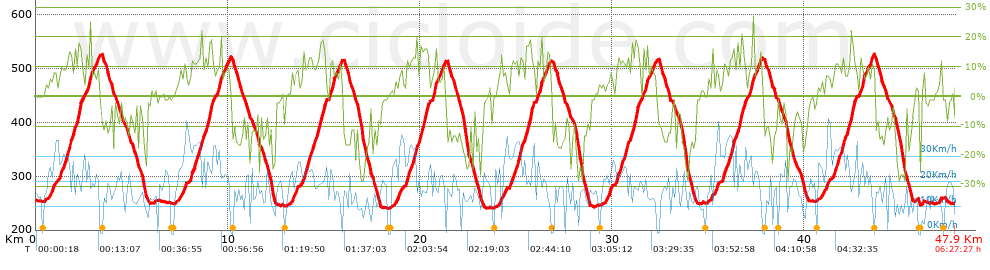
Distance in Km: 47.93
Climb in m: 2252
IBP: 183 BYC

Toni R
Author: Toni R
311 published routes

Add to my Group or Club

 Height in m      Climb in %      Speed in Km/h      Speed < 2 Km/h

Climbs > 5%

Climbs >5% Climbs >10% Climbs >15% Climbs >20% Climbs >25%
 Steep slope of 343 m.   Average slope  Distances  Download as waypoint
1
 Km 0.71  7%  62 m
2
 Km 0.772  7%  105 m
3
 Km 0.877  9%  176 m
 Steep slope of 1278 m.  Average slope  Distances  Download as waypoint
4
 Km 1.244  7%  31 m
5
 Km 1.275  11%  176 m
6
 Km 1.45  12%  102 m
7
 Km 1.552  13%  246 m
8
 Km 1.798  10%  208 m
9
 Km 2.006  13%  190 m
10
 Km 2.196  18%  111 m
11
 Km 2.307  17%  70 m
12
 Km 2.377  10%  144 m
 Steep slope of 735 m.  Average slope  Distances  Download as waypoint
13
 Km 2.631  11%  191 m
14
 Km 2.823  9%  544 m
 Steep slope of 358 m.  Average slope  Distances  Download as waypoint
15
 Km 7.45  7%  358 m
 Steep slope of 2023 m.  Average slope  Distances  Download as waypoint
16
 Km 8.038  6%  39 m
17
 Km 8.077  11%  501 m
18
 Km 8.578  12%  240 m
19
 Km 8.818  11%  144 m
20
 Km 8.961  16%  182 m
21
 Km 9.143  16%  68 m
22
 Km 9.211  7%  266 m
23
 Km 9.477  13%  163 m
24
 Km 9.64  9%  420 m
 Steep slope of 290 m.  Average slope  Distances  Download as waypoint
25
 Km 13.328  8%  290 m
 Steep slope of 1259 m.  Average slope  Distances  Download as waypoint
26
 Km 13.88  10%  35 m
27
 Km 13.915  12%  527 m
28
 Km 14.442  10%  195 m
29
 Km 14.637  13%  181 m
30
 Km 14.818  17%  173 m
31
 Km 14.991  12%  64 m
32
 Km 15.055  11%  84 m
 Steep slope of 721 m.  Average slope  Distances  Download as waypoint
33
 Km 15.252  10%  35 m
34
 Km 15.287  11%  170 m
35
 Km 15.456  10%  516 m
 Steep slope of 250 m.  Average slope  Distances  Download as waypoint
36
 Km 18.66  7%  250 m
 Steep slope of 1246 m.  Average slope  Distances  Download as waypoint
37
 Km 19.254  6%  36 m
38
 Km 19.29  11%  559 m
39
 Km 19.849  11%  180 m
40
 Km 20.029  13%  151 m
41
 Km 20.181  18%  176 m
42
 Km 20.357  13%  65 m
43
 Km 20.422  10%  79 m
 Steep slope of 717 m.  Average slope  Distances  Download as waypoint
44
 Km 20.616  6%  39 m
45
 Km 20.655  13%  194 m
46
 Km 20.849  9%  337 m
47
 Km 21.186  12%  147 m
 Steep slope of 277 m.  Average slope  Distances  Download as waypoint
48
 Km 24.149  8%  277 m
 Steep slope of 1289 m.  Average slope  Distances  Download as waypoint
49
 Km 24.699  7%  43 m
50
 Km 24.742  12%  147 m
51
 Km 24.889  9%  99 m
52
 Km 24.989  12%  319 m
53
 Km 25.308  10%  175 m
54
 Km 25.482  14%  37 m
55
 Km 25.519  15%  243 m
56
 Km 25.762  16%  115 m
57
 Km 25.877  10%  111 m
 Steep slope of 738 m.  Average slope  Distances  Download as waypoint
58
 Km 26.102  10%  187 m
59
 Km 26.289  10%  551 m
 Steep slope of 255 m.  Average slope  Distances  Download as waypoint
60
 Km 29.685  7%  76 m
61
 Km 29.761  6%  106 m
62
 Km 29.868  10%  73 m
 Steep slope of 1271 m.  Average slope  Distances  Download as waypoint
63
 Km 30.234  9%  67 m
64
 Km 30.301  12%  512 m
65
 Km 30.814  10%  214 m
66
 Km 31.028  13%  208 m
67
 Km 31.236  18%  151 m
68
 Km 31.387  12%  71 m
69
 Km 31.458  11%  48 m
 Steep slope of 788 m.  Average slope  Distances  Download as waypoint
70
 Km 31.607  6%  43 m
71
 Km 31.649  12%  161 m
72
 Km 31.81  9%  584 m
 Steep slope of 253 m.  Average slope  Distances  Download as waypoint
73
 Km 35.208  7%  253 m
 Steep slope of 1276 m.  Average slope  Distances  Download as waypoint
74
 Km 35.755  9%  38 m
75
 Km 35.793  11%  393 m
76
 Km 36.186  11%  97 m
77
 Km 36.283  16%  95 m
78
 Km 36.378  7%  110 m
79
 Km 36.488  12%  175 m
80
 Km 36.662  17%  161 m
81
 Km 36.824  13%  100 m
82
 Km 36.923  9%  107 m
 Steep slope of 709 m.  Average slope  Distances  Download as waypoint
83
 Km 37.131  8%  48 m
84
 Km 37.179  15%  184 m
85
 Km 37.363  9%  477 m
 Steep slope of 442 m.  Average slope  Distances  Download as waypoint
86
 Km 40.896  7%  442 m
 Steep slope of 1251 m.  Average slope  Distances  Download as waypoint
87
 Km 41.523  7%  35 m
88
 Km 41.559  12%  519 m
89
 Km 42.077  10%  193 m
90
 Km 42.27  13%  142 m
91
 Km 42.412  18%  133 m
92
 Km 42.545  12%  229 m
 Steep slope of 746 m.  Average slope  Distances  Download as waypoint
93
 Km 42.881  10%  570 m
94
 Km 43.451  12%  108 m
95
 Km 43.558  5%  68 m


Description of the route


Presence of ramps


 Climbs  Distance  % of the total  Speed  Your speed would be  Time  Your time would be
   15 - 30%  2.692  5.62  18.86  ?  0:08:34  ?
   10 - 15%  7.376  15.39  22.16  ?  0:19:58  ?
   5 - 10%  9.14  19.07  24.74  ?  0:22:10  ?
   1 - 5%  5.419  11.31  17.9  ?  0:18:10  ?
   Total*  24.626 Km  51.38 %  21.46 Km/h  ? Km/h    1:08:52 h  ? h  
 Flat
   1 - -1%  3.717 Km  7.76 %  16.18 Km/h  ? Km/h    0:13:47 h  ? h  
 Descents
   -1 - -5%  4.564  9.52  13.57  ?  0:20:11  ?
   -5 - -10%  3.751  7.83  14.24  ?  0:15:48  ?
   -10 - -15%  5.083  10.61  15.47  ?  0:19:43  ?
   -15 - -30%  6.186  12.91  11.67  ?  0:31:49  ?
   Total*  19.584 Km  40.86 %  13.43 Km/h  ? Km/h    1:27:31 h  ? h  
* The total has not necessarily coincide with the sum of the partials after correction of errors

How long would it take you?

How long would it take you to cover this route?
There are routes without a valid time information, but with your average stats you can assess the possible duration

Toni R to cover this route you've need a time of:   2:50:10 h 
If you sign in and have a minimum of two tracks of this same modality, you can know your time for this route, calculated from your stats..


¿Cuanto consumirá tu E-BIKE?

Entra tu E-IBP (formato n,nn)

E-IBP :   X 183 = 


 Detected activity type =  ()
 Penalization due to track conditions: 54 %   ( > 50 % = MTB, < 50 % = RDB)
 Reliability of the track: A   (2252/94/0/-/-/94)
 Correction level applied to the track: 0
DIFFICULTY OF THE ROUTE
IBP = 183 BYC
According to your statistics
 Your time in motion would be: ? h
Your average speed would be: ? Km/h
 

 Total Distance: 47.93 Km
 Analysed distance: 47.93 Km
 Linear distance: 0.1 Km

 Cumulated positive ramps: 2251.54 m  list of points info
 Cumulated negative ramps: 2258.23 m
 Maximum height: 529.6 m
 Minimum height: 240.35 m
 Climbing Ratio: 9.14 %
 Descent ratio: 11.53 %
 Cumulated postive ramps per Km: 46.98 m
 Cumulated negative ramps per Km: 47.12 m

 Total time: 6:27:27 h
 Time in movement: 2:50:10 h
 According to your statistics
 Your time in motion would be: ? h  
 Stopped time: 3:37:17 h
 Maximum slope filter: ~30 %
 Minimum separation analysed: ~30 m
 Number of points: 3283   (cad. 14.6 m)
 Significant waypoints: 1283   (cad. 37.36 m / 39.08 %)

 Changes in direction per Km: 11.41
 Changes in direction > 5º por Km: 8.12
 Cumulated straight stretches: 7.806 Km
 Straight stretches per Km: 162.86 m
 Penalized slope changes: 21
 Penalized slope changes per Km: 0.438

 Average speed in total: 7.42 Km/h
 Average speed while moving: 16.9 Km/h
 According to your statistics
 Your average speed would be: ? Km/h  
 Maximum sustained speed: 44.71 Km/h


Comments

You can be the first one in commenting this route

 
My comments
:
Add comment  (Registered users)
 
Notify me answers to my comment  Do not notify answers to my comment


Share this route with a friend

Your friend will receive a message with a link to this page:
will see your email and your user name if you do it as registered user.


Write here your name (optional)

E-mail address of your friend(s). You can include various addresses separated by commas

Text or comment (optional) maximum 255 characters long, 255 Available characters

As a non registered users you need to fill-in the captcha text.
  Change image
Type the image characters.
 
 Share with a friend


Visited history

Delete history

Marked routes for review later or compare

My favorites


  Notify anomaly in this route Share in Facebook