Un poco se todo

MTB
MTB
Ref..: 1140530
Published: 03/03/2024
Performed: 02/03/2024
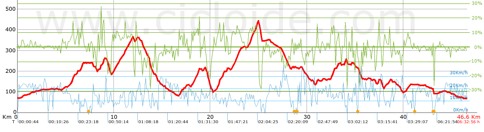
Distance in Km: 46.65
Climb in m: 1331
IBP: 113 BYC

Toni R
Author: Toni R
311 published routes

Add to my Group or Club

 Height in m      Climb in %      Speed in Km/h      Speed < 2 Km/h

Climbs > 10%

Climbs >5% Climbs >10% Climbs >15% Climbs >20% Climbs >25%
 Steep slope of 241 m.   Average slope  Distances  Download as waypoint
1
 Km 5.702  14%  138 m
2
 Km 6.156  12%  103 m
 Steep slope of 134 m.  Average slope  Distances  Download as waypoint
3
 Km 6.641  14%  134 m
 Steep slope of 97 m.  Average slope  Distances  Download as waypoint
4
 Km 8.617  19%  97 m
 Steep slope of 168 m.  Average slope  Distances  Download as waypoint
5
 Km 8.822  14%  97 m
6
 Km 8.919  17%  71 m
 Steep slope of 272 m.  Average slope  Distances  Download as waypoint
7
 Km 10.507  10%  98 m
8
 Km 11.576  10%  174 m
 Steep slope of 115 m.  Average slope  Distances  Download as waypoint
9
 Km 12.215  12%  115 m
 Steep slope of 314 m.  Average slope  Distances  Download as waypoint
10
 Km 18.236  10%  171 m
11
 Km 18.407  10%  105 m
 Steep slope of 688 m.  Average slope  Distances  Download as waypoint
12
 Km 20.673  10%  207 m
13
 Km 20.881  23%  65 m
14
 Km 20.946  16%  33 m
15
 Km 21.257  14%  35 m
16
 Km 21.292  16%  102 m
 Steep slope of 405 m.  Average slope  Distances  Download as waypoint
17
 Km 22.494  11%  405 m
 Steep slope of 743 m.  Average slope  Distances  Download as waypoint
18
 Km 24.009  11%  438 m
19
 Km 24.63  13%  131 m
20
 Km 24.761  17%  136 m
21
 Km 24.897  20%  38 m
 Steep slope of 140 m.  Average slope  Distances  Download as waypoint
22
 Km 30.971  13%  140 m
 Steep slope of 367 m.  Average slope  Distances  Download as waypoint
23
 Km 32.478  12%  367 m
 Steep slope of 174 m.  Average slope  Distances  Download as waypoint
24
 Km 33.881  15%  97 m
25
 Km 33.978  15%  77 m
 Steep slope of 101 m.  Average slope  Distances  Download as waypoint
26
 Km 37.374  15%  101 m


Description of the route


Presence of ramps


 Climbs  Distance  % of the total  Speed  Your speed would be  Time  Your time would be
   15 - 30%  1.083  2.32  7.65  ?  0:08:30  ?
   10 - 15%  3.749  8.04  9.76  ?  0:23:03  ?
   5 - 10%  6.051  12.97  10.68  ?  0:33:59  ?
   1 - 5%  8.787  18.84  13.67  ?  0:38:34  ?
   Total*  19.67 Km  42.17 %  11.34 Km/h  ? Km/h    1:44:06 h  ? h  
 Flat
   1 - -1%  8.633 Km  18.51 %  15.62 Km/h  ? Km/h    0:33:10 h  ? h  
 Descents
   -1 - -5%  8.976  19.24  15.97  ?  0:33:43  ?
   -5 - -10%  4.747  10.18  18.57  ?  0:15:20  ?
   -10 - -15%  2.257  4.84  15.78  ?  0:08:35  ?
   -15 - -30%  2.365  5.07  9.69  ?  0:14:39  ?
   Total*  18.346 Km  39.33 %  15.23 Km/h  ? Km/h    1:12:17 h  ? h  
* The total has not necessarily coincide with the sum of the partials after correction of errors

How long would it take you?

How long would it take you to cover this route?
There are routes without a valid time information, but with your average stats you can assess the possible duration

Toni R to cover this route you've need a time of:   3:29:33 h 
If you sign in and have a minimum of two tracks of this same modality, you can know your time for this route, calculated from your stats..


¿Cuanto consumirá tu E-BIKE?

Entra tu E-IBP (formato n,nn)

E-IBP :   X 113 = 


 Detected activity type =  ()
 Penalization due to track conditions: 77 %   ( > 50 % = MTB, < 50 % = RDB)
 Reliability of the track: B   (1333/65/0/-/-/65)
 Correction level applied to the track: 0
DIFFICULTY OF THE ROUTE
IBP = 113 BYC
According to your statistics
 Your time in motion would be: ? h
Your average speed would be: ? Km/h
 

 Total Distance: 46.65 Km
 Analysed distance: 46.65 Km
 Linear distance: 0.17 Km

 Cumulated positive ramps: 1331.25 m  list of points info
 Cumulated negative ramps: 1330.97 m
 Maximum height: 444.05 m
 Minimum height: 67 m
 Climbing Ratio: 6.77 %
 Descent ratio: 7.25 %
 Cumulated postive ramps per Km: 28.54 m
 Cumulated negative ramps per Km: 28.53 m

 Total time: 6:32:56 h
 Time in movement: 3:29:33 h
 According to your statistics
 Your time in motion would be: ? h  
 Stopped time: 3:03:23 h
 Maximum slope filter: ~30 %
 Minimum separation analysed: ~30 m
 Number of points: 3407   (cad. 13.69 m)
 Significant waypoints: 1259   (cad. 37.05 m / 36.95 %)

 Changes in direction per Km: 11.47
 Changes in direction > 5º por Km: 8.55
 Cumulated straight stretches: 7.691 Km
 Straight stretches per Km: 164.87 m
 Penalized slope changes: 14
 Penalized slope changes per Km: 0.3

 Average speed in total: 7.12 Km/h
 Average speed while moving: 13.36 Km/h
 According to your statistics
 Your average speed would be: ? Km/h  
 Maximum sustained speed: 40.78 Km/h


Comments

You can be the first one in commenting this route

 
My comments
:
Add comment  (Registered users)
 
Notify me answers to my comment  Do not notify answers to my comment


Share this route with a friend

Your friend will receive a message with a link to this page:
will see your email and your user name if you do it as registered user.


Write here your name (optional)

E-mail address of your friend(s). You can include various addresses separated by commas

Text or comment (optional) maximum 255 characters long, 255 Available characters

As a non registered users you need to fill-in the captcha text.
  Change image
Type the image characters.
 
 Share with a friend


Visited history

Delete history

Marked routes for review later or compare

My favorites


  Notify anomaly in this route Share in Facebook