Frio y nieve por Campa Cimera

MTB
MTB
Ref..: 1140359
Published: 01/03/2024
Performed: 01/03/2024
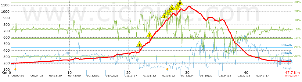
Distance in Km: 47.66
Climb in m: 1100
IBP: 110 BYC

Near ...
Andarujo, Artosa (Langreo), Barraca, La (Ciaño-Langreo), Barraca, La (Langreo), Barripies, Barros
Eduluna
Author: Eduluna
428 published routes

Add to my Group or Club

 Height in m      Climb in %      Speed in Km/h      Speed < 2 Km/h

Climbs > 5%

Climbs >5% Climbs >10% Climbs >15% Climbs >20% Climbs >25%
 Steep slope of 268 m.   Average slope  Distances  Download as waypoint
1
 Km 10.612  10%  129 m
2
 Km 10.74  8%  139 m
 Steep slope of 230 m.  Average slope  Distances  Download as waypoint
3
 Km 17.544  9%  230 m
 Steep slope of 132 m.  Average slope  Distances  Download as waypoint
4
 Km 17.923  7%  132 m
 Steep slope of 220 m.  Average slope  Distances  Download as waypoint
5
 Km 20.228  9%  220 m
 Steep slope of 777 m.  Average slope  Distances  Download as waypoint
6
 Km 21.804  10%  71 m
7
 Km 21.875  17%  241 m
8
 Km 22.116  15%  248 m
9
 Km 22.364  9%  217 m
 Steep slope of 244 m.  Average slope  Distances  Download as waypoint
10
 Km 22.738  10%  29 m
11
 Km 22.768  12%  106 m
12
 Km 22.873  16%  70 m
13
 Km 22.943  10%  39 m
 Steep slope of 184 m.  Average slope  Distances  Download as waypoint
14
 Km 23.087  9%  184 m
 Steep slope of 1159 m.  Average slope  Distances  Download as waypoint
15
 Km 23.515  5%  38 m
16
 Km 23.553  11%  30 m
17
 Km 23.583  17%  327 m
18
 Km 23.91  13%  203 m
19
 Km 24.113  13%  107 m
20
 Km 24.22  14%  149 m
21
 Km 24.369  10%  115 m
22
 Km 24.484  14%  190 m
 Steep slope of 535 m.  Average slope  Distances  Download as waypoint
23
 Km 24.814  10%  418 m
24
 Km 25.232  12%  117 m
 Steep slope of 946 m.  Average slope  Distances  Download as waypoint
25
 Km 25.451  8%  232 m
26
 Km 25.683  14%  174 m
27
 Km 25.857  10%  140 m
28
 Km 25.997  12%  76 m
29
 Km 26.073  15%  123 m
30
 Km 26.197  15%  201 m
 Steep slope of 234 m.  Average slope  Distances  Download as waypoint
31
 Km 26.636  19%  184 m
32
 Km 26.82  12%  50 m
 Steep slope of 542 m.  Average slope  Distances  Download as waypoint
33
 Km 26.977  6%  74 m
34
 Km 27.051  17%  119 m
35
 Km 27.17  11%  216 m
36
 Km 27.386  20%  70 m
37
 Km 27.456  16%  33 m
38
 Km 27.489  9%  30 m
 Steep slope of 650 m.  Average slope  Distances  Download as waypoint
39
 Km 28.116  17%  151 m
40
 Km 28.267  14%  106 m
41
 Km 28.373  16%  100 m
42
 Km 28.474  7%  155 m
43
 Km 28.629  10%  105 m
44
 Km 28.734  22%  33 m
 Steep slope of 34 m.  Average slope  Distances  Download as waypoint
45
 Km 28.805  21%  34 m
 Steep slope of 629 m.  Average slope  Distances  Download as waypoint
46
 Km 29.572  8%  207 m
47
 Km 29.78  12%  113 m
48
 Km 29.893  9%  129 m
49
 Km 30.022  13%  110 m
50
 Km 30.132  10%  70 m
 Steep slope of 385 m.  Average slope  Distances  Download as waypoint
51
 Km 33.234  6%  38 m
52
 Km 33.273  13%  218 m
53
 Km 33.49  6%  129 m
 Steep slope of 157 m.  Average slope  Distances  Download as waypoint
54
 Km 35.352  8%  157 m


Description of the route


Presence of ramps


 Climbs  Distance  % of the total  Speed  Your speed would be  Time  Your time would be
   15 - 30%  2.096  4.4  3.82  ?  0:32:55  ?
   10 - 15%  2.817  5.91  5.37  ?  0:31:30  ?
   5 - 10%  2.884  6.05  6.84  ?  0:25:17  ?
   1 - 5%  8.364  17.55  14.05  ?  0:35:43  ?
   Total*  16.162 Km  33.91 %  7.73 Km/h  ? Km/h    2:05:25 h  ? h  
 Flat
   1 - -1%  17.538 Km  36.8 %  18.67 Km/h  ? Km/h    0:56:21 h  ? h  
 Descents
   -1 - -5%  6.026  12.64  20.6  ?  0:17:33  ?
   -5 - -10%  4.483  9.41  25.74  ?  0:10:27  ?
   -10 - -15%  1.524  3.2  21.68  ?  0:04:13  ?
   -15 - -30%  1.927  4.04  18.55  ?  0:06:14  ?
   Total*  13.959 Km  29.29 %  21.78 Km/h  ? Km/h    0:38:27 h  ? h  
* The total has not necessarily coincide with the sum of the partials after correction of errors

How long would it take you?

How long would it take you to cover this route?
There are routes without a valid time information, but with your average stats you can assess the possible duration

Eduluna to cover this route you've need a time of:   3:40:13 h 
If you sign in and have a minimum of two tracks of this same modality, you can know your time for this route, calculated from your stats..


¿Cuanto consumirá tu E-BIKE?

Entra tu E-IBP (formato n,nn)

E-IBP :   X 110 = 


 Detected activity type =  ()
 Penalization due to track conditions: 63 %   ( > 50 % = MTB, < 50 % = RDB)
 Reliability of the track: A   (1100/73/0/-/-/73)
 Correction level applied to the track: 0
DIFFICULTY OF THE ROUTE
IBP = 110 BYC
According to your statistics
 Your time in motion would be: ? h
Your average speed would be: ? Km/h
 

 Total Distance: 47.66 Km
 Analysed distance: 47.66 Km
 Linear distance: 0.07 Km

 Cumulated positive ramps: 1100.4 m  list of points info
 Cumulated negative ramps: 1098.6 m
 Maximum height: 1080.8 m
 Minimum height: 198.8 m
 Climbing Ratio: 6.81 %
 Descent ratio: 7.87 %
 Cumulated postive ramps per Km: 23.09 m
 Cumulated negative ramps per Km: 23.05 m

 Total time: 4:02:29 h
 Time in movement: 3:40:13 h
 According to your statistics
 Your time in motion would be: ? h  
 Stopped time: 0:22:16 h
 Maximum slope filter: ~30 %
 Minimum separation analysed: ~30 m
 Number of points: 2407   (cad. 19.8 m)
 Significant waypoints: 1195   (cad. 39.88 m / 49.65 %)

 Changes in direction per Km: 10.37
 Changes in direction > 5º por Km: 7.64
 Cumulated straight stretches: 10.401 Km
 Straight stretches per Km: 218.23 m
 Penalized slope changes: 8
 Penalized slope changes per Km: 0.168

 Average speed in total: 11.79 Km/h
 Average speed while moving: 12.99 Km/h
 According to your statistics
 Your average speed would be: ? Km/h  
 Maximum sustained speed: 49.2 Km/h


Comments

You can be the first one in commenting this route

 
My comments
:
Add comment  (Registered users)
 
Notify me answers to my comment  Do not notify answers to my comment


Share this route with a friend

Your friend will receive a message with a link to this page:
will see your email and your user name if you do it as registered user.


Write here your name (optional)

E-mail address of your friend(s). You can include various addresses separated by commas

Text or comment (optional) maximum 255 characters long, 255 Available characters

As a non registered users you need to fill-in the captcha text.
  Change image
Type the image characters.
 
 Share with a friend


Visited history

Delete history

Marked routes for review later or compare

My favorites


  Notify anomaly in this route Share in Facebook