Sant Pere De Ribes (Barcelona)

MTB
MTB
Ref..: 1139992
Published: 26/02/2024
Performed: 25/02/2024
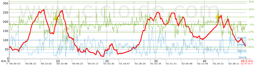
Distance in Km: 48.49
Climb in m: 1167
IBP: 92 BYC

Near ...
Barquera, La, Mas D'En Serra, El, Mas Roig, De (Zona), Puigmolto, Roquetes, Les (Sant Pere De Ribes), Saifores (Barri)
edualcrellum
Author: edualcrellum
512 published routes

Add to my Group or Club

 Height in m      Climb in %      Speed in Km/h      Speed < 2 Km/h

Climbs > 5%

Climbs >5% Climbs >10% Climbs >15% Climbs >20% Climbs >25%
 Steep slope of 112 m.   Average slope  Distances  Download as waypoint
1
 Km 1.971  11%  112 m
 Steep slope of 922 m.  Average slope  Distances  Download as waypoint
2
 Km 3.816  9%  448 m
3
 Km 4.263  13%  201 m
4
 Km 4.464  9%  273 m
 Steep slope of 142 m.  Average slope  Distances  Download as waypoint
5
 Km 5.34  6%  142 m
 Steep slope of 305 m.  Average slope  Distances  Download as waypoint
6
 Km 5.81  7%  67 m
7
 Km 5.877  11%  100 m
8
 Km 5.977  7%  138 m
 Steep slope of 111 m.  Average slope  Distances  Download as waypoint
9
 Km 6.565  7%  111 m
 Steep slope of 903 m.  Average slope  Distances  Download as waypoint
10
 Km 9.033  13%  294 m
11
 Km 9.327  8%  239 m
12
 Km 9.566  19%  97 m
13
 Km 9.662  10%  33 m
14
 Km 9.695  6%  72 m
15
 Km 9.767  6%  168 m
 Steep slope of 110 m.  Average slope  Distances  Download as waypoint
16
 Km 10.301  15%  110 m
 Steep slope of 100 m.  Average slope  Distances  Download as waypoint
17
 Km 15.151  8%  100 m
 Steep slope of 131 m.  Average slope  Distances  Download as waypoint
18
 Km 15.563  13%  131 m
 Steep slope of 176 m.  Average slope  Distances  Download as waypoint
19
 Km 17.759  9%  176 m
 Steep slope of 276 m.  Average slope  Distances  Download as waypoint
20
 Km 19.275  8%  176 m
21
 Km 19.451  15%  100 m
 Steep slope of 133 m.  Average slope  Distances  Download as waypoint
22
 Km 20.021  8%  133 m
 Steep slope of 128 m.  Average slope  Distances  Download as waypoint
23
 Km 20.468  15%  128 m
 Steep slope of 137 m.  Average slope  Distances  Download as waypoint
24
 Km 20.742  8%  137 m
 Steep slope of 103 m.  Average slope  Distances  Download as waypoint
25
 Km 25.078  8%  103 m
 Steep slope of 175 m.  Average slope  Distances  Download as waypoint
26
 Km 26.011  8%  175 m
 Steep slope of 708 m.  Average slope  Distances  Download as waypoint
27
 Km 26.58  8%  443 m
28
 Km 27.024  14%  131 m
29
 Km 27.154  9%  134 m
 Steep slope of 273 m.  Average slope  Distances  Download as waypoint
30
 Km 27.754  13%  202 m
31
 Km 27.956  8%  71 m
 Steep slope of 168 m.  Average slope  Distances  Download as waypoint
32
 Km 28.179  15%  134 m
33
 Km 28.313  5%  34 m
 Steep slope of 142 m.  Average slope  Distances  Download as waypoint
34
 Km 28.719  12%  106 m
35
 Km 28.825  6%  36 m
 Steep slope of 146 m.  Average slope  Distances  Download as waypoint
36
 Km 29.595  6%  146 m
 Steep slope of 250 m.  Average slope  Distances  Download as waypoint
37
 Km 29.915  7%  250 m
 Steep slope of 237 m.  Average slope  Distances  Download as waypoint
38
 Km 32.6  13%  165 m
39
 Km 32.765  11%  72 m
 Steep slope of 196 m.  Average slope  Distances  Download as waypoint
40
 Km 33.016  8%  196 m
 Steep slope of 106 m.  Average slope  Distances  Download as waypoint
41
 Km 34.906  9%  106 m
 Steep slope of 206 m.  Average slope  Distances  Download as waypoint
42
 Km 35.308  9%  206 m
 Steep slope of 233 m.  Average slope  Distances  Download as waypoint
43
 Km 42.73  16%  133 m
44
 Km 42.863  18%  31 m
45
 Km 42.895  9%  69 m
 Steep slope of 142 m.  Average slope  Distances  Download as waypoint
46
 Km 43.968  5%  142 m
 Steep slope of 149 m.  Average slope  Distances  Download as waypoint
47
 Km 44.243  7%  149 m
 Steep slope of 212 m.  Average slope  Distances  Download as waypoint
48
 Km 44.533  7%  212 m
 Steep slope of 144 m.  Average slope  Distances  Download as waypoint
49
 Km 47.265  8%  144 m


Description of the route


Presence of ramps


 Climbs  Distance  % of the total  Speed  Your speed would be  Time  Your time would be
   15 - 30%  0.928  1.91  5.66  ?  0:09:50  ?
   10 - 15%  2.29  4.72  8.31  ?  0:16:32  ?
   5 - 10%  5.514  11.37  11.18  ?  0:29:36  ?
   1 - 5%  12.642  26.07  16.74  ?  0:45:19  ?
   Total*  21.373 Km  44.08 %  12.66 Km/h  ? Km/h    1:41:17 h  ? h  
 Flat
   1 - -1%  8.635 Km  17.81 %  23.39 Km/h  ? Km/h    0:22:09 h  ? h  
 Descents
   -1 - -5%  9.62  19.84  26.48  ?  0:21:48  ?
   -5 - -10%  5.36  11.05  26.32  ?  0:12:13  ?
   -10 - -15%  2.124  4.38  24.74  ?  0:05:09  ?
   -15 - -30%  1.375  2.84  16.24  ?  0:05:05  ?
   Total*  18.48 Km  38.11 %  25.06 Km/h  ? Km/h    0:44:15 h  ? h  
* The total has not necessarily coincide with the sum of the partials after correction of errors

How long would it take you?

How long would it take you to cover this route?
There are routes without a valid time information, but with your average stats you can assess the possible duration

edualcrellum to cover this route you've need a time of:   2:47:41 h 
If you sign in and have a minimum of two tracks of this same modality, you can know your time for this route, calculated from your stats..


¿Cuanto consumirá tu E-BIKE?

Entra tu E-IBP (formato n,nn)

E-IBP :   X 92 = 


 Detected activity type =  ()
 Penalization due to track conditions: 70 %   ( > 50 % = MTB, < 50 % = RDB)
 Reliability of the track: B   (1167/63/0/-/-/63)
 Correction level applied to the track: 0
DIFFICULTY OF THE ROUTE
IBP = 92 BYC
According to your statistics
 Your time in motion would be: ? h
Your average speed would be: ? Km/h
 

 Total Distance: 48.49 Km
 Analysed distance: 48.49 Km
 Linear distance: 0.03 Km

 Cumulated positive ramps: 1167 m  list of points info
 Cumulated negative ramps: 1156.8 m
 Maximum height: 267 m
 Minimum height: 12.4 m
 Climbing Ratio: 5.46 %
 Descent ratio: 6.26 %
 Cumulated postive ramps per Km: 24.07 m
 Cumulated negative ramps per Km: 23.86 m

 Total time: 2:47:41 h
 Time in movement: 2:47:41 h
 According to your statistics
 Your time in motion would be: ? h  
 Stopped time: 0:00:00 h
 Maximum slope filter: ~30 %
 Minimum separation analysed: ~30 m
 Number of points: 3427   (cad. 14.15 m)
 Significant waypoints: 1300   (cad. 37.3 m / 37.93 %)

 Changes in direction per Km: 10.5
 Changes in direction > 5º por Km: 8.37
 Cumulated straight stretches: 6.607 Km
 Straight stretches per Km: 136.25 m
 Penalized slope changes: 13
 Penalized slope changes per Km: 0.268

 Average speed in total: 17.35 Km/h
 Average speed while moving: 17.35 Km/h
 According to your statistics
 Your average speed would be: ? Km/h  
 Maximum sustained speed: 49.8 Km/h


Comments

You can be the first one in commenting this route

 
My comments
:
Add comment  (Registered users)
 
Notify me answers to my comment  Do not notify answers to my comment


Share this route with a friend

Your friend will receive a message with a link to this page:
will see your email and your user name if you do it as registered user.


Write here your name (optional)

E-mail address of your friend(s). You can include various addresses separated by commas

Text or comment (optional) maximum 255 characters long, 255 Available characters

As a non registered users you need to fill-in the captcha text.
  Change image
Type the image characters.
 
 Share with a friend


Visited history

Delete history

Marked routes for review later or compare

My favorites


  Notify anomaly in this route Share in Facebook