Barrillo matutino,por los alrededores del Escobin.

MTB
MTB
Ref..: 1139364
Published: 20/02/2024
Performed: 19/02/2024
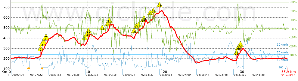
Distance in Km: 35.93
Climb in m: 1202
IBP: 124 BYC

Near ...
Andarujo, Artosa (Langreo), Barraca, La (Ciaño-Langreo), Barraca, La (Langreo), Barripies, Barros
Eduluna
Author: Eduluna
428 published routes

Add to my Group or Club

 Height in m      Climb in %      Speed in Km/h      Speed < 2 Km/h

Climbs > 5%

Climbs >5% Climbs >10% Climbs >15% Climbs >20% Climbs >25%
 Steep slope of 1180 m.   Average slope  Distances  Download as waypoint
1
 Km 3.784  7%  68 m
2
 Km 3.852  13%  44 m
3
 Km 3.897  24%  183 m
4
 Km 4.08  16%  33 m
5
 Km 4.113  7%  108 m
6
 Km 4.221  18%  210 m
7
 Km 4.431  16%  34 m
8
 Km 4.465  12%  105 m
9
 Km 4.571  13%  358 m
10
 Km 4.928  11%  37 m
 Steep slope of 137 m.  Average slope  Distances  Download as waypoint
11
 Km 5.078  8%  137 m
 Steep slope of 309 m.  Average slope  Distances  Download as waypoint
12
 Km 5.317  7%  309 m
 Steep slope of 222 m.  Average slope  Distances  Download as waypoint
13
 Km 7.381  5%  222 m
 Steep slope of 705 m.  Average slope  Distances  Download as waypoint
14
 Km 9.613  12%  231 m
15
 Km 9.844  19%  73 m
16
 Km 9.917  19%  108 m
17
 Km 10.025  20%  76 m
18
 Km 10.101  12%  146 m
19
 Km 10.247  14%  71 m
 Steep slope of 346 m.  Average slope  Distances  Download as waypoint
20
 Km 11.309  10%  346 m
 Steep slope of 210 m.  Average slope  Distances  Download as waypoint
21
 Km 11.796  8%  62 m
22
 Km 11.858  16%  103 m
23
 Km 11.96  6%  45 m
 Steep slope of 598 m.  Average slope  Distances  Download as waypoint
24
 Km 12.346  7%  255 m
25
 Km 12.601  19%  154 m
26
 Km 12.755  22%  189 m
 Steep slope of 96 m.  Average slope  Distances  Download as waypoint
27
 Km 13.101  19%  96 m
 Steep slope of 424 m.  Average slope  Distances  Download as waypoint
28
 Km 15.988  17%  218 m
29
 Km 16.206  22%  44 m
30
 Km 16.25  6%  162 m
 Steep slope of 121 m.  Average slope  Distances  Download as waypoint
31
 Km 16.565  23%  121 m
 Steep slope of 526 m.  Average slope  Distances  Download as waypoint
32
 Km 16.907  7%  277 m
33
 Km 17.184  17%  37 m
34
 Km 17.221  22%  212 m
 Steep slope of 286 m.  Average slope  Distances  Download as waypoint
35
 Km 17.811  9%  223 m
36
 Km 18.033  20%  63 m
 Steep slope of 509 m.  Average slope  Distances  Download as waypoint
37
 Km 18.279  10%  226 m
38
 Km 18.505  21%  109 m
39
 Km 18.615  9%  174 m
 Steep slope of 234 m.  Average slope  Distances  Download as waypoint
40
 Km 19.073  7%  157 m
41
 Km 19.231  12%  77 m
 Steep slope of 101 m.  Average slope  Distances  Download as waypoint
42
 Km 19.421  12%  101 m
 Steep slope of 118 m.  Average slope  Distances  Download as waypoint
43
 Km 27.559  5%  118 m
 Steep slope of 264 m.  Average slope  Distances  Download as waypoint
44
 Km 29.27  13%  39 m
45
 Km 29.309  27%  193 m
46
 Km 29.502  11%  32 m
 Steep slope of 504 m.  Average slope  Distances  Download as waypoint
47
 Km 29.638  13%  33 m
48
 Km 29.671  17%  100 m
49
 Km 29.771  11%  148 m
50
 Km 29.918  9%  223 m


Description of the route


Presence of ramps


 Climbs  Distance  % of the total  Speed  Your speed would be  Time  Your time would be
   15 - 30%  2.426  6.75  4.33  ?  0:33:38  ?
   10 - 15%  2.044  5.69  5.13  ?  0:23:54  ?
   5 - 10%  3.329  9.26  6.62  ?  0:30:11  ?
   1 - 5%  6.581  18.31  12.03  ?  0:32:50  ?
   Total*  14.38 Km  40.02 %  7.16 Km/h  ? Km/h    2:00:33 h  ? h  
 Flat
   1 - -1%  7.056 Km  19.64 %  16.22 Km/h  ? Km/h    0:26:06 h  ? h  
 Descents
   -1 - -5%  5.538  15.41  16.57  ?  0:20:03  ?
   -5 - -10%  4.339  12.08  17.13  ?  0:15:12  ?
   -10 - -15%  2.374  6.61  14.15  ?  0:10:04  ?
   -15 - -30%  2.245  6.25  13.38  ?  0:10:04  ?
   Total*  14.496 Km  40.34 %  15.7 Km/h  ? Km/h    0:55:23 h  ? h  
* The total has not necessarily coincide with the sum of the partials after correction of errors

How long would it take you?

How long would it take you to cover this route?
There are routes without a valid time information, but with your average stats you can assess the possible duration

Eduluna to cover this route you've need a time of:   3:22:02 h 
If you sign in and have a minimum of two tracks of this same modality, you can know your time for this route, calculated from your stats..


¿Cuanto consumirá tu E-BIKE?

Entra tu E-IBP (formato n,nn)

E-IBP :   X 124 = 


 Detected activity type =  ()
 Penalization due to track conditions: 83 %   ( > 50 % = MTB, < 50 % = RDB)
 Reliability of the track: B   (1205/64/0/-/-/64)
 Correction level applied to the track: 0
DIFFICULTY OF THE ROUTE
IBP = 124 BYC
According to your statistics
 Your time in motion would be: ? h
Your average speed would be: ? Km/h
 

 Total Distance: 35.93 Km
 Analysed distance: 35.93 Km
 Linear distance: 0.04 Km

 Cumulated positive ramps: 1202.42 m  list of points info
 Cumulated negative ramps: 1201.82 m
 Maximum height: 671.2 m
 Minimum height: 164.8 m
 Climbing Ratio: 8.36 %
 Descent ratio: 8.29 %
 Cumulated postive ramps per Km: 33.47 m
 Cumulated negative ramps per Km: 33.45 m

 Total time: 4:01:19 h
 Time in movement: 3:22:02 h
 According to your statistics
 Your time in motion would be: ? h  
 Stopped time: 0:39:17 h
 Maximum slope filter: ~30 %
 Minimum separation analysed: ~30 m
 Number of points: 2058   (cad. 17.46 m)
 Significant waypoints: 919   (cad. 39.1 m / 44.66 %)

 Changes in direction per Km: 11.3
 Changes in direction > 5º por Km: 8.18
 Cumulated straight stretches: 5.584 Km
 Straight stretches per Km: 155.41 m
 Penalized slope changes: 12
 Penalized slope changes per Km: 0.334

 Average speed in total: 8.93 Km/h
 Average speed while moving: 10.67 Km/h
 According to your statistics
 Your average speed would be: ? Km/h  
 Maximum sustained speed: 41.99 Km/h


Comments

You can be the first one in commenting this route

 
My comments
:
Add comment  (Registered users)
 
Notify me answers to my comment  Do not notify answers to my comment


Share this route with a friend

Your friend will receive a message with a link to this page:
will see your email and your user name if you do it as registered user.


Write here your name (optional)

E-mail address of your friend(s). You can include various addresses separated by commas

Text or comment (optional) maximum 255 characters long, 255 Available characters

As a non registered users you need to fill-in the captcha text.
  Change image
Type the image characters.
 
 Share with a friend


Visited history

Delete history

Marked routes for review later or compare

My favorites


  Notify anomaly in this route Share in Facebook