18/02/24-LOZOYA/HORIZONTAL BAJA

MTB
MTB
Ref..: 1139068
Published: 18/02/2024
Performed: 18/02/2024
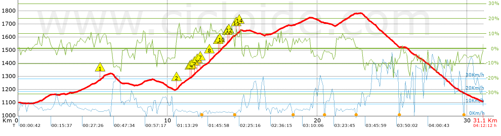
Distance in Km: 31.08
Climb in m: 1001
IBP: 71 BYC

TRULLI
Author: TRULLI
416 published routes

Add to my Group or Club

 Height in m      Climb in %      Speed in Km/h      Speed < 2 Km/h

Climbs > 5%

Climbs >5% Climbs >10% Climbs >15% Climbs >20% Climbs >25%
 Steep slope of 108 m.   Average slope  Distances  Download as waypoint
1
 Km 1.293  7%  108 m
 Steep slope of 474 m.  Average slope  Distances  Download as waypoint
2
 Km 1.561  8%  474 m
 Steep slope of 122 m.  Average slope  Distances  Download as waypoint
3
 Km 3.967  5%  122 m
 Steep slope of 160 m.  Average slope  Distances  Download as waypoint
4
 Km 4.196  5%  160 m
 Steep slope of 440 m.  Average slope  Distances  Download as waypoint
5
 Km 4.499  7%  440 m
 Steep slope of 704 m.  Average slope  Distances  Download as waypoint
6
 Km 5.091  8%  405 m
7
 Km 5.496  10%  166 m
8
 Km 5.662  11%  133 m
 Steep slope of 243 m.  Average slope  Distances  Download as waypoint
9
 Km 8.213  7%  104 m
10
 Km 8.317  9%  108 m
11
 Km 8.425  11%  31 m
 Steep slope of 4377 m.  Average slope  Distances  Download as waypoint
12
 Km 10.475  5%  112 m
13
 Km 10.588  13%  319 m
14
 Km 10.907  8%  118 m
15
 Km 11.025  8%  458 m
16
 Km 11.483  10%  108 m
17
 Km 11.591  10%  145 m
18
 Km 11.736  12%  224 m
19
 Km 11.959  10%  162 m
20
 Km 12.121  12%  163 m
21
 Km 12.284  8%  520 m
22
 Km 12.804  12%  510 m
23
 Km 13.315  10%  111 m
24
 Km 13.426  12%  507 m
25
 Km 13.933  12%  101 m
26
 Km 14.034  14%  313 m
27
 Km 14.347  5%  153 m
28
 Km 14.5  9%  30 m
29
 Km 14.53  14%  108 m
30
 Km 14.637  8%  114 m
31
 Km 14.752  15%  101 m
 Steep slope of 306 m.  Average slope  Distances  Download as waypoint
32
 Km 16.884  6%  306 m
 Steep slope of 223 m.  Average slope  Distances  Download as waypoint
33
 Km 17.3  7%  223 m
 Steep slope of 248 m.  Average slope  Distances  Download as waypoint
34
 Km 17.673  6%  248 m
 Steep slope of 133 m.  Average slope  Distances  Download as waypoint
35
 Km 18.729  5%  133 m
 Steep slope of 405 m.  Average slope  Distances  Download as waypoint
36
 Km 18.968  6%  405 m
 Steep slope of 1279 m.  Average slope  Distances  Download as waypoint
37
 Km 21.206  7%  1279 m


Description of the route


Presence of ramps


 Climbs  Distance  % of the total  Speed  Your speed would be  Time  Your time would be
   15 - 30%  0.345  1.11  4.43  ?  0:04:40  ?
   10 - 15%  2.585  8.32  5.17  ?  0:30:00  ?
   5 - 10%  6.607  21.26  6.58  ?  1:00:14  ?
   1 - 5%  4.971  15.99  8.14  ?  0:36:38  ?
   Total*  14.507 Km  46.68 %  6.62 Km/h  ? Km/h    2:11:32 h  ? h  
 Flat
   1 - -1%  2.321 Km  7.47 %  10.56 Km/h  ? Km/h    0:13:11 h  ? h  
 Descents
   -1 - -5%  5.125  16.49  15.62  ?  0:19:41  ?
   -5 - -10%  5.639  18.14  19.48  ?  0:17:22  ?
   -10 - -15%  3.081  9.91  27.52  ?  0:06:43  ?
   -15 - -30%  0.405  1.3  18.71  ?  0:01:18  ?
   Total*  14.251 Km  45.85 %  18.97 Km/h  ? Km/h    0:45:04 h  ? h  
* The total has not necessarily coincide with the sum of the partials after correction of errors

How long would it take you?

How long would it take you to cover this route?
There are routes without a valid time information, but with your average stats you can assess the possible duration

TRULLI to cover this route you've need a time of:   3:09:47 h 
If you sign in and have a minimum of two tracks of this same modality, you can know your time for this route, calculated from your stats..


¿Cuanto consumirá tu E-BIKE?

Entra tu E-IBP (formato n,nn)

E-IBP :   X 71 = 


 Detected activity type =  ()
 Penalization due to track conditions: 57 %   ( > 50 % = MTB, < 50 % = RDB)
 Reliability of the track: A   (1001/88/0/-/-/88)
 Correction level applied to the track: 0
DIFFICULTY OF THE ROUTE
IBP = 71 BYC
According to your statistics
 Your time in motion would be: ? h
Your average speed would be: ? Km/h
 

 Total Distance: 31.08 Km
 Analysed distance: 31.08 Km
 Linear distance: 0.04 Km

 Cumulated positive ramps: 1001 m  list of points info
 Cumulated negative ramps: 990 m
 Maximum height: 1783.2 m
 Minimum height: 1094.2 m
 Climbing Ratio: 6.9 %
 Descent ratio: 6.95 %
 Cumulated postive ramps per Km: 32.21 m
 Cumulated negative ramps per Km: 31.85 m

 Total time: 4:12:12 h
 Time in movement: 3:09:47 h
 According to your statistics
 Your time in motion would be: ? h  
 Stopped time: 1:02:25 h
 Maximum slope filter: ~30 %
 Minimum separation analysed: ~30 m
 Number of points: 1910   (cad. 16.27 m)
 Significant waypoints: 809   (cad. 38.42 m / 42.36 %)

 Changes in direction per Km: 10.17
 Changes in direction > 5º por Km: 6.31
 Cumulated straight stretches: 5.835 Km
 Straight stretches per Km: 187.74 m
 Penalized slope changes: 8
 Penalized slope changes per Km: 0.257

 Average speed in total: 7.39 Km/h
 Average speed while moving: 9.83 Km/h
 According to your statistics
 Your average speed would be: ? Km/h  
 Maximum sustained speed: 51.11 Km/h


Comments

You can be the first one in commenting this route

 
My comments
:
Add comment  (Registered users)
 
Notify me answers to my comment  Do not notify answers to my comment


Share this route with a friend

Your friend will receive a message with a link to this page:
will see your email and your user name if you do it as registered user.


Write here your name (optional)

E-mail address of your friend(s). You can include various addresses separated by commas

Text or comment (optional) maximum 255 characters long, 255 Available characters

As a non registered users you need to fill-in the captcha text.
  Change image
Type the image characters.
 
 Share with a friend


Visited history

Delete history

Marked routes for review later or compare

My favorites


  Notify anomaly in this route Share in Facebook