Con el jefecito

MTB
MTB
Ref..: 1124285
Published: 08/10/2023
Performed: 08/10/2023
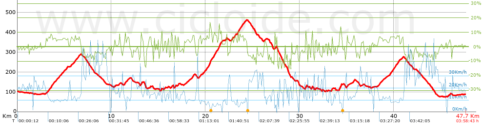
Distance in Km: 47.69
Climb in m: 1116
IBP: 72 BYC

Rafa_Lopez
Author: Rafa_Lopez
567 published routes

Add to my Group or Club

 Height in m      Climb in %      Speed in Km/h      Speed < 2 Km/h

Climbs > 5%

Climbs >5% Climbs >10% Climbs >15% Climbs >20% Climbs >25%
 Steep slope of 459 m.   Average slope  Distances  Download as waypoint
1
 Km 3.23  7%  459 m
 Steep slope of 288 m.  Average slope  Distances  Download as waypoint
2
 Km 3.81  6%  288 m
 Steep slope of 340 m.  Average slope  Distances  Download as waypoint
3
 Km 4.207  6%  340 m
 Steep slope of 447 m.  Average slope  Distances  Download as waypoint
4
 Km 4.668  6%  447 m
 Steep slope of 148 m.  Average slope  Distances  Download as waypoint
5
 Km 5.228  6%  148 m
 Steep slope of 249 m.  Average slope  Distances  Download as waypoint
6
 Km 5.638  6%  249 m
 Steep slope of 594 m.  Average slope  Distances  Download as waypoint
7
 Km 6.067  6%  594 m
 Steep slope of 186 m.  Average slope  Distances  Download as waypoint
8
 Km 11.361  8%  186 m
 Steep slope of 210 m.  Average slope  Distances  Download as waypoint
9
 Km 11.657  5%  210 m
 Steep slope of 177 m.  Average slope  Distances  Download as waypoint
10
 Km 13.097  9%  177 m
 Steep slope of 106 m.  Average slope  Distances  Download as waypoint
11
 Km 14.049  9%  106 m
 Steep slope of 138 m.  Average slope  Distances  Download as waypoint
12
 Km 16.346  8%  138 m
 Steep slope of 132 m.  Average slope  Distances  Download as waypoint
13
 Km 16.715  7%  132 m
 Steep slope of 150 m.  Average slope  Distances  Download as waypoint
14
 Km 17.034  7%  150 m
 Steep slope of 212 m.  Average slope  Distances  Download as waypoint
15
 Km 18.606  7%  212 m
 Steep slope of 142 m.  Average slope  Distances  Download as waypoint
16
 Km 19.4  6%  142 m
 Steep slope of 320 m.  Average slope  Distances  Download as waypoint
17
 Km 19.644  6%  320 m
 Steep slope of 592 m.  Average slope  Distances  Download as waypoint
18
 Km 20.062  7%  383 m
19
 Km 20.444  13%  173 m
20
 Km 20.618  9%  36 m
 Steep slope of 769 m.  Average slope  Distances  Download as waypoint
21
 Km 20.761  8%  667 m
22
 Km 21.428  14%  102 m
 Steep slope of 132 m.  Average slope  Distances  Download as waypoint
23
 Km 22.079  6%  132 m
 Steep slope of 166 m.  Average slope  Distances  Download as waypoint
24
 Km 22.717  7%  166 m
 Steep slope of 207 m.  Average slope  Distances  Download as waypoint
25
 Km 23.027  7%  207 m
 Steep slope of 660 m.  Average slope  Distances  Download as waypoint
26
 Km 23.366  8%  34 m
27
 Km 23.399  12%  131 m
28
 Km 23.53  7%  495 m
 Steep slope of 132 m.  Average slope  Distances  Download as waypoint
29
 Km 24.126  5%  132 m
 Steep slope of 96 m.  Average slope  Distances  Download as waypoint
30
 Km 27.339  8%  96 m
 Steep slope of 148 m.  Average slope  Distances  Download as waypoint
31
 Km 30.594  11%  148 m
 Steep slope of 104 m.  Average slope  Distances  Download as waypoint
32
 Km 31.27  11%  104 m
 Steep slope of 170 m.  Average slope  Distances  Download as waypoint
33
 Km 33.365  8%  170 m
 Steep slope of 318 m.  Average slope  Distances  Download as waypoint
34
 Km 34.166  8%  113 m
35
 Km 34.279  13%  106 m
36
 Km 34.385  8%  99 m
 Steep slope of 146 m.  Average slope  Distances  Download as waypoint
37
 Km 34.98  8%  146 m
 Steep slope of 220 m.  Average slope  Distances  Download as waypoint
38
 Km 35.619  6%  220 m
 Steep slope of 338 m.  Average slope  Distances  Download as waypoint
39
 Km 38.421  6%  338 m
 Steep slope of 1051 m.  Average slope  Distances  Download as waypoint
40
 Km 39.558  7%  1051 m
 Steep slope of 153 m.  Average slope  Distances  Download as waypoint
41
 Km 40.834  6%  153 m


Description of the route


Presence of ramps


 Climbs  Distance  % of the total  Speed  Your speed would be  Time  Your time would be
   15 - 30%  0.099  0.21  5.42  ?  0:01:06  ?
   10 - 15%  1.046  2.19  8.95  ?  0:07:01  ?
   5 - 10%  9.822  20.59  10.42  ?  0:56:33  ?
   1 - 5%  9.711  20.36  12.64  ?  0:46:05  ?
   Total*  20.679 Km  43.36 %  11.2 Km/h  ? Km/h    1:50:45 h  ? h  
 Flat
   1 - -1%  6.437 Km  13.5 %  17.74 Km/h  ? Km/h    0:21:46 h  ? h  
 Descents
   -1 - -5%  10.321  21.64  21.64  ?  0:28:37  ?
   -5 - -10%  8.631  18.1  23.43  ?  0:22:06  ?
   -10 - -15%  1.288  2.7  15.62  ?  0:04:57  ?
   -15 - -30%  0.336  0.71  12.36  ?  0:01:38  ?
   Total*  20.577 Km  43.15 %  21.55 Km/h  ? Km/h    0:57:18 h  ? h  
* The total has not necessarily coincide with the sum of the partials after correction of errors

How long would it take you?

How long would it take you to cover this route?
There are routes without a valid time information, but with your average stats you can assess the possible duration

Rafa_Lopez to cover this route you've need a time of:   3:09:49 h 
If you sign in and have a minimum of two tracks of this same modality, you can know your time for this route, calculated from your stats..


¿Cuanto consumirá tu E-BIKE?

Entra tu E-IBP (formato n,nn)

E-IBP :   X 72 = 


 Detected activity type =  ()
 Penalization due to track conditions: 69 %   ( > 50 % = MTB, < 50 % = RDB)
 Reliability of the track: B   (1116/63/0/-/-/63)
 Correction level applied to the track: 0
DIFFICULTY OF THE ROUTE
IBP = 72 BYC
According to your statistics
 Your time in motion would be: ? h
Your average speed would be: ? Km/h
 

 Total Distance: 47.69 Km
 Analysed distance: 47.69 Km
 Linear distance: 0.13 Km

 Cumulated positive ramps: 1116 m  list of points info
 Cumulated negative ramps: 1129.4 m
 Maximum height: 463.6 m
 Minimum height: 74 m
 Climbing Ratio: 5.4 %
 Descent ratio: 5.49 %
 Cumulated postive ramps per Km: 23.4 m
 Cumulated negative ramps per Km: 23.68 m

 Total time: 3:58:43 h
 Time in movement: 3:09:49 h
 According to your statistics
 Your time in motion would be: ? h  
 Stopped time: 0:48:54 h
 Maximum slope filter: ~30 %
 Minimum separation analysed: ~30 m
 Number of points: 3635   (cad. 13.12 m)
 Significant waypoints: 1318   (cad. 36.19 m / 36.26 %)

 Changes in direction per Km: 10.3
 Changes in direction > 5º por Km: 6.63
 Cumulated straight stretches: 10.453 Km
 Straight stretches per Km: 219.19 m
 Penalized slope changes: 9
 Penalized slope changes per Km: 0.189

 Average speed in total: 11.99 Km/h
 Average speed while moving: 15.07 Km/h
 According to your statistics
 Your average speed would be: ? Km/h  
 Maximum sustained speed: 50.31 Km/h


Comments

You can be the first one in commenting this route

 
My comments
:
Add comment  (Registered users)
 
Notify me answers to my comment  Do not notify answers to my comment


Share this route with a friend

Your friend will receive a message with a link to this page:
will see your email and your user name if you do it as registered user.


Write here your name (optional)

E-mail address of your friend(s). You can include various addresses separated by commas

Text or comment (optional) maximum 255 characters long, 255 Available characters

As a non registered users you need to fill-in the captcha text.
  Change image
Type the image characters.
 
 Share with a friend


Visited history

Delete history

Marked routes for review later or compare

My favorites


  Notify anomaly in this route Share in Facebook