La Rimada/San Pedrin/Villanueva/La Pola/Pica Lloreu

MTB
MTB
Ref..: 1117437
Published: 22/08/2023
Performed: 21/08/2023
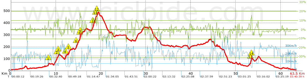
Distance in Km: 63.53
Climb in m: 1124
IBP: 87 BYC

Near ...
Aroles, Bandin, Baones, Baragaña (Carreño), Barquera, La (Carreño), Barreres (Albandi_Carreño)

 Height in m      Climb in %      Speed in Km/h      Speed < 2 Km/h

Climbs > 5%

Climbs >5% Climbs >10% Climbs >15% Climbs >20% Climbs >25%
 Steep slope of 149 m.   Average slope  Distances  Download as waypoint
1
 Km 3.013  7%  149 m
 Steep slope of 35 m.  Average slope  Distances  Download as waypoint
2
 Km 8.255  11%  35 m
 Steep slope of 248 m.  Average slope  Distances  Download as waypoint
3
 Km 9.518  7%  248 m
 Steep slope of 427 m.  Average slope  Distances  Download as waypoint
4
 Km 9.872  8%  286 m
5
 Km 10.157  11%  141 m
 Steep slope of 239 m.  Average slope  Distances  Download as waypoint
6
 Km 10.411  8%  68 m
7
 Km 10.479  11%  139 m
8
 Km 10.618  6%  32 m
 Steep slope of 398 m.  Average slope  Distances  Download as waypoint
9
 Km 12.03  7%  81 m
10
 Km 12.111  10%  136 m
11
 Km 12.247  9%  181 m
 Steep slope of 375 m.  Average slope  Distances  Download as waypoint
12
 Km 12.748  10%  33 m
13
 Km 12.782  12%  205 m
14
 Km 12.986  8%  137 m
 Steep slope of 107 m.  Average slope  Distances  Download as waypoint
15
 Km 13.623  8%  107 m
 Steep slope of 1114 m.  Average slope  Distances  Download as waypoint
16
 Km 14.442  8%  69 m
17
 Km 14.512  11%  349 m
18
 Km 14.861  7%  395 m
19
 Km 15.256  11%  39 m
20
 Km 15.296  17%  97 m
21
 Km 15.392  14%  165 m
 Steep slope of 183 m.  Average slope  Distances  Download as waypoint
22
 Km 15.805  9%  183 m
 Steep slope of 269 m.  Average slope  Distances  Download as waypoint
23
 Km 16.321  9%  269 m
 Steep slope of 1057 m.  Average slope  Distances  Download as waypoint
24
 Km 17.919  8%  208 m
25
 Km 18.127  12%  536 m
26
 Km 18.663  8%  103 m
27
 Km 18.766  11%  141 m
28
 Km 18.907  13%  69 m
 Steep slope of 340 m.  Average slope  Distances  Download as waypoint
29
 Km 19.074  10%  33 m
30
 Km 19.107  12%  171 m
31
 Km 19.278  8%  136 m
 Steep slope of 112 m.  Average slope  Distances  Download as waypoint
32
 Km 22.033  8%  112 m
 Steep slope of 104 m.  Average slope  Distances  Download as waypoint
33
 Km 26.82  9%  104 m
 Steep slope of 685 m.  Average slope  Distances  Download as waypoint
34
 Km 27.641  9%  685 m
 Steep slope of 423 m.  Average slope  Distances  Download as waypoint
35
 Km 28.987  8%  423 m
 Steep slope of 138 m.  Average slope  Distances  Download as waypoint
36
 Km 29.551  8%  138 m
 Steep slope of 173 m.  Average slope  Distances  Download as waypoint
37
 Km 30.609  6%  173 m
 Steep slope of 179 m.  Average slope  Distances  Download as waypoint
38
 Km 39.732  6%  179 m
 Steep slope of 276 m.  Average slope  Distances  Download as waypoint
39
 Km 43.813  7%  276 m
 Steep slope of 110 m.  Average slope  Distances  Download as waypoint
40
 Km 44.302  6%  110 m
 Steep slope of 131 m.  Average slope  Distances  Download as waypoint
41
 Km 45.686  9%  131 m
 Steep slope of 114 m.  Average slope  Distances  Download as waypoint
42
 Km 50.735  7%  114 m
 Steep slope of 282 m.  Average slope  Distances  Download as waypoint
43
 Km 52.881  6%  282 m
 Steep slope of 341 m.  Average slope  Distances  Download as waypoint
44
 Km 53.272  12%  208 m
45
 Km 53.48  17%  98 m
46
 Km 53.579  10%  35 m
 Steep slope of 379 m.  Average slope  Distances  Download as waypoint
47
 Km 54.578  6%  379 m


Description of the route


Presence of ramps


 Climbs  Distance  % of the total  Speed  Your speed would be  Time  Your time would be
   15 - 30%  0.327  0.51  5.92  ?  0:03:19  ?
   10 - 15%  2.88  4.53  7.53  ?  0:22:57  ?
   5 - 10%  5.928  9.33  10.16  ?  0:35:01  ?
   1 - 5%  12.031  18.94  15.2  ?  0:47:29  ?
   Total*  21.165 Km  33.32 %  11.68 Km/h  ? Km/h    1:48:46 h  ? h  
 Flat
   1 - -1%  17.453 Km  27.47 %  20.84 Km/h  ? Km/h    0:50:15 h  ? h  
 Descents
   -1 - -5%  16.419  25.84  25.1  ?  0:39:15  ?
   -5 - -10%  6.459  10.17  30.44  ?  0:12:44  ?
   -10 - -15%  1.779  2.8  30.21  ?  0:03:32  ?
   -15 - -30%  0.254  0.4  32.63  ?  0:00:28  ?
   Total*  24.912 Km  39.21 %  26.7 Km/h  ? Km/h    0:55:59 h  ? h  
* The total has not necessarily coincide with the sum of the partials after correction of errors

How long would it take you?

How long would it take you to cover this route?
There are routes without a valid time information, but with your average stats you can assess the possible duration

Manuel_Sanchez_Huerta to cover this route you've need a time of:   3:35:00 h 
If you sign in and have a minimum of two tracks of this same modality, you can know your time for this route, calculated from your stats..


¿Cuanto consumirá tu E-BIKE?

Entra tu E-IBP (formato n,nn)

E-IBP :   X 87 = 


 Detected activity type =  ()
 Penalization due to track conditions: 60 %   ( > 50 % = MTB, < 50 % = RDB)
 Reliability of the track: B   (1124/59/0/-/-/59)
 Correction level applied to the track: 0
DIFFICULTY OF THE ROUTE
IBP = 87 BYC
According to your statistics
 Your time in motion would be: ? h
Your average speed would be: ? Km/h
 

 Total Distance: 63.53 Km
 Analysed distance: 63.53 Km
 Linear distance: 0.09 Km

 Cumulated positive ramps: 1124 m  list of points info
 Cumulated negative ramps: 1122.6 m
 Maximum height: 491.2 m
 Minimum height: 8.1 m
 Climbing Ratio: 5.31 %
 Descent ratio: 4.51 %
 Cumulated postive ramps per Km: 17.69 m
 Cumulated negative ramps per Km: 17.67 m

 Total time: 3:40:39 h
 Time in movement: 3:35:00 h
 According to your statistics
 Your time in motion would be: ? h  
 Stopped time: 0:05:39 h
 Maximum slope filter: ~30 %
 Minimum separation analysed: ~30 m
 Number of points: 4803   (cad. 13.23 m)
 Significant waypoints: 1777   (cad. 35.75 m / 37 %)

 Changes in direction per Km: 11.65
 Changes in direction > 5º por Km: 7.79
 Cumulated straight stretches: 12.925 Km
 Straight stretches per Km: 203.45 m
 Penalized slope changes: 13
 Penalized slope changes per Km: 0.205

 Average speed in total: 17.28 Km/h
 Average speed while moving: 17.73 Km/h
 According to your statistics
 Your average speed would be: ? Km/h  
 Maximum sustained speed: 52.22 Km/h


Comments

You can be the first one in commenting this route

 
My comments
:
Add comment  (Registered users)
 
Notify me answers to my comment  Do not notify answers to my comment


Share this route with a friend

Your friend will receive a message with a link to this page:
will see your email and your user name if you do it as registered user.


Write here your name (optional)

E-mail address of your friend(s). You can include various addresses separated by commas

Text or comment (optional) maximum 255 characters long, 255 Available characters

As a non registered users you need to fill-in the captcha text.
  Change image
Type the image characters.
 
 Share with a friend


Visited history

Delete history

Marked routes for review later or compare

My favorites


  Notify anomaly in this route Share in Facebook