Enduro X Arnoia

MTB
MTB
Ref..: 1117230
Published: 21/08/2023
Performed: 20/08/2023
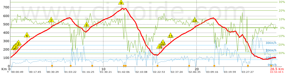
Distance in Km: 28.54
Climb in m: 1300
IBP: 88 BYC

Endoureiro
Author: Endoureiro
350 published routes

Add to my Group or Club

 Height in m      Climb in %      Speed in Km/h      Speed < 2 Km/h

Climbs > 5%

Climbs >5% Climbs >10% Climbs >15% Climbs >20% Climbs >25%
 Steep slope of 2874 m.   Average slope  Distances  Download as waypoint
1
 Km 0.062  9%  296 m
2
 Km 0.357  10%  131 m
3
 Km 0.488  10%  96 m
4
 Km 0.585  12%  231 m
5
 Km 0.816  11%  97 m
6
 Km 0.913  13%  266 m
7
 Km 1.179  9%  544 m
8
 Km 1.723  11%  102 m
9
 Km 1.825  8%  1111 m
 Steep slope of 140 m.  Average slope  Distances  Download as waypoint
10
 Km 3.039  5%  140 m
 Steep slope of 303 m.  Average slope  Distances  Download as waypoint
11
 Km 3.346  6%  303 m
 Steep slope of 203 m.  Average slope  Distances  Download as waypoint
12
 Km 3.79  6%  203 m
 Steep slope of 337 m.  Average slope  Distances  Download as waypoint
13
 Km 4.098  8%  236 m
14
 Km 4.334  13%  101 m
 Steep slope of 307 m.  Average slope  Distances  Download as waypoint
15
 Km 4.629  6%  307 m
 Steep slope of 533 m.  Average slope  Distances  Download as waypoint
16
 Km 5.046  7%  533 m
 Steep slope of 168 m.  Average slope  Distances  Download as waypoint
17
 Km 5.69  5%  168 m
 Steep slope of 619 m.  Average slope  Distances  Download as waypoint
18
 Km 8.148  12%  338 m
19
 Km 8.486  10%  281 m
 Steep slope of 271 m.  Average slope  Distances  Download as waypoint
20
 Km 8.903  6%  271 m
 Steep slope of 496 m.  Average slope  Distances  Download as waypoint
21
 Km 9.342  7%  496 m
 Steep slope of 166 m.  Average slope  Distances  Download as waypoint
22
 Km 9.937  5%  166 m
 Steep slope of 774 m.  Average slope  Distances  Download as waypoint
23
 Km 10.709  8%  774 m
 Steep slope of 377 m.  Average slope  Distances  Download as waypoint
24
 Km 11.589  7%  244 m
25
 Km 11.833  10%  101 m
26
 Km 11.934  10%  32 m
 Steep slope of 104 m.  Average slope  Distances  Download as waypoint
27
 Km 12.186  12%  104 m
 Steep slope of 2665 m.  Average slope  Distances  Download as waypoint
28
 Km 15.703  8%  299 m
29
 Km 16.002  11%  235 m
30
 Km 16.237  12%  103 m
31
 Km 16.339  13%  264 m
32
 Km 16.603  9%  590 m
33
 Km 17.194  10%  99 m
34
 Km 17.293  8%  1075 m
 Steep slope of 323 m.  Average slope  Distances  Download as waypoint
35
 Km 18.793  7%  323 m
 Steep slope of 654 m.  Average slope  Distances  Download as waypoint
36
 Km 19.214  7%  520 m
37
 Km 19.734  14%  105 m
38
 Km 19.839  6%  29 m
 Steep slope of 282 m.  Average slope  Distances  Download as waypoint
39
 Km 20.034  6%  282 m
 Steep slope of 543 m.  Average slope  Distances  Download as waypoint
40
 Km 20.464  7%  543 m
 Steep slope of 101 m.  Average slope  Distances  Download as waypoint
41
 Km 21.155  6%  101 m
 Steep slope of 306 m.  Average slope  Distances  Download as waypoint
42
 Km 24.563  11%  306 m


Description of the route


Presence of ramps


 Climbs  Distance  % of the total  Speed  Your speed would be  Time  Your time would be
   15 - 30%  0.468  1.64  7.14  ?  0:03:56  ?
   10 - 15%  2.687  9.41  8.54  ?  0:18:53  ?
   5 - 10%  10.182  35.67  9.99  ?  1:01:08  ?
   1 - 5%  4.995  17.5  12.06  ?  0:24:51  ?
   Total*  18.332 Km  64.22 %  10.11 Km/h  ? Km/h    1:48:48 h  ? h  
 Flat
   1 - -1%  0.867 Km  3.04 %  15.08 Km/h  ? Km/h    0:03:27 h  ? h  
 Descents
   -1 - -5%  1.909  6.69  19.63  ?  0:05:50  ?
   -5 - -10%  1.95  6.83  15.84  ?  0:07:23  ?
   -10 - -15%  1.379  4.83  19.94  ?  0:04:09  ?
   -15 - -30%  4.108  14.39  8.81  ?  0:27:58  ?
   Total*  9.346 Km  32.74 %  12.37 Km/h  ? Km/h    0:45:20 h  ? h  
* The total has not necessarily coincide with the sum of the partials after correction of errors

How long would it take you?

How long would it take you to cover this route?
There are routes without a valid time information, but with your average stats you can assess the possible duration

Endoureiro to cover this route you've need a time of:   2:37:35 h 
If you sign in and have a minimum of two tracks of this same modality, you can know your time for this route, calculated from your stats..


¿Cuanto consumirá tu E-BIKE?

Entra tu E-IBP (formato n,nn)

E-IBP :   X 88 = 


 Detected activity type =  ()
 Penalization due to track conditions: 52 %   ( > 50 % = MTB, < 50 % = RDB)
 Reliability of the track: A   (1300/95/0/-/-/95)
 Correction level applied to the track: 0
DIFFICULTY OF THE ROUTE
IBP = 88 BYC
According to your statistics
 Your time in motion would be: ? h
Your average speed would be: ? Km/h
 

 Total Distance: 28.54 Km
 Analysed distance: 28.54 Km
 Linear distance: 0.53 Km

 Cumulated positive ramps: 1300.2 m  list of points info
 Cumulated negative ramps: 1302.8 m
 Maximum height: 688.8 m
 Minimum height: 84.6 m
 Climbing Ratio: 7.09 %
 Descent ratio: 13.94 %
 Cumulated postive ramps per Km: 45.56 m
 Cumulated negative ramps per Km: 45.65 m

 Total time: 3:54:44 h
 Time in movement: 2:37:35 h
 According to your statistics
 Your time in motion would be: ? h  
 Stopped time: 1:17:09 h
 Maximum slope filter: ~30 %
 Minimum separation analysed: ~30 m
 Number of points: 2309   (cad. 12.36 m)
 Significant waypoints: 807   (cad. 35.37 m / 34.95 %)

 Changes in direction per Km: 11.81
 Changes in direction > 5º por Km: 9.64
 Cumulated straight stretches: 2.826 Km
 Straight stretches per Km: 99.02 m
 Penalized slope changes: 7
 Penalized slope changes per Km: 0.245

 Average speed in total: 7.3 Km/h
 Average speed while moving: 10.87 Km/h
 According to your statistics
 Your average speed would be: ? Km/h  
 Maximum sustained speed: 44.96 Km/h


Comments

You can be the first one in commenting this route

 
My comments
:
Add comment  (Registered users)
 
Notify me answers to my comment  Do not notify answers to my comment


Share this route with a friend

Your friend will receive a message with a link to this page:
will see your email and your user name if you do it as registered user.


Write here your name (optional)

E-mail address of your friend(s). You can include various addresses separated by commas

Text or comment (optional) maximum 255 characters long, 255 Available characters

As a non registered users you need to fill-in the captcha text.
  Change image
Type the image characters.
 
 Share with a friend


Visited history

Delete history

Marked routes for review later or compare

My favorites


  Notify anomaly in this route Share in Facebook