La purito 2023

MTB
MTB
Ref..: 1114928
Published: 07/08/2023
Performed: 06/08/2023
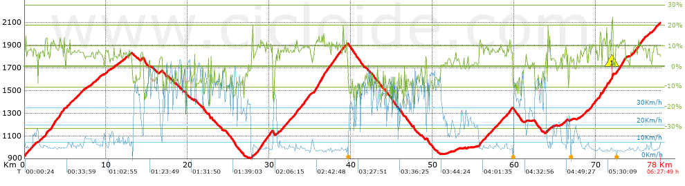
Distance in Km: 77.98
Climb in m: 3449
IBP: 217 BYC

Javi_IV
Author: Javi_IV
215 published routes

Add to my Group or Club

 Height in m      Climb in %      Speed in Km/h      Speed < 2 Km/h

Climbs > 5%

Climbs >5% Climbs >10% Climbs >15% Climbs >20% Climbs >25%
 Steep slope of 204 m.   Average slope  Distances  Download as waypoint
1
 Km 0.034  7%  70 m
2
 Km 0.104  14%  134 m
 Steep slope of 1425 m.  Average slope  Distances  Download as waypoint
3
 Km 0.344  7%  1425 m
 Steep slope of 419 m.  Average slope  Distances  Download as waypoint
4
 Km 1.906  7%  419 m
 Steep slope of 210 m.  Average slope  Distances  Download as waypoint
5
 Km 2.52  14%  210 m
 Steep slope of 2052 m.  Average slope  Distances  Download as waypoint
6
 Km 2.793  5%  33 m
7
 Km 2.826  6%  405 m
8
 Km 3.231  12%  576 m
9
 Km 3.808  9%  465 m
10
 Km 4.272  13%  266 m
11
 Km 4.538  9%  241 m
12
 Km 4.779  13%  66 m
 Steep slope of 2229 m.  Average slope  Distances  Download as waypoint
13
 Km 5.115  7%  2229 m
 Steep slope of 164 m.  Average slope  Distances  Download as waypoint
14
 Km 7.484  5%  164 m
 Steep slope of 279 m.  Average slope  Distances  Download as waypoint
15
 Km 8.156  7%  279 m
 Steep slope of 876 m.  Average slope  Distances  Download as waypoint
16
 Km 8.675  7%  876 m
 Steep slope of 446 m.  Average slope  Distances  Download as waypoint
17
 Km 9.915  8%  446 m
 Steep slope of 172 m.  Average slope  Distances  Download as waypoint
18
 Km 10.892  8%  172 m
 Steep slope of 107 m.  Average slope  Distances  Download as waypoint
19
 Km 11.402  5%  107 m
 Steep slope of 177 m.  Average slope  Distances  Download as waypoint
20
 Km 11.649  7%  177 m
 Steep slope of 510 m.  Average slope  Distances  Download as waypoint
21
 Km 12.003  7%  510 m
 Steep slope of 304 m.  Average slope  Distances  Download as waypoint
22
 Km 12.768  7%  304 m
 Steep slope of 304 m.  Average slope  Distances  Download as waypoint
23
 Km 14.215  7%  304 m
 Steep slope of 241 m.  Average slope  Distances  Download as waypoint
24
 Km 16.562  6%  241 m
 Steep slope of 118 m.  Average slope  Distances  Download as waypoint
25
 Km 22.829  6%  118 m
 Steep slope of 169 m.  Average slope  Distances  Download as waypoint
26
 Km 27.805  6%  35 m
27
 Km 27.84  10%  101 m
28
 Km 27.94  20%  33 m
 Steep slope of 2222 m.  Average slope  Distances  Download as waypoint
29
 Km 28.174  7%  404 m
30
 Km 28.579  11%  95 m
31
 Km 28.674  9%  127 m
32
 Km 28.801  12%  521 m
33
 Km 29.321  9%  160 m
34
 Km 29.482  9%  167 m
35
 Km 29.649  10%  748 m
 Steep slope of 273 m.  Average slope  Distances  Download as waypoint
36
 Km 30.838  6%  273 m
 Steep slope of 3853 m.  Average slope  Distances  Download as waypoint
37
 Km 31.319  8%  1815 m
38
 Km 33.135  11%  242 m
39
 Km 33.377  9%  906 m
40
 Km 34.283  10%  130 m
41
 Km 34.413  10%  93 m
42
 Km 34.506  10%  163 m
43
 Km 34.669  9%  504 m
 Steep slope of 3623 m.  Average slope  Distances  Download as waypoint
44
 Km 35.385  9%  264 m
45
 Km 35.649  13%  929 m
46
 Km 36.578  16%  124 m
47
 Km 36.702  15%  33 m
48
 Km 36.735  9%  196 m
49
 Km 36.931  11%  492 m
50
 Km 37.423  6%  134 m
51
 Km 37.557  11%  295 m
52
 Km 37.852  9%  398 m
53
 Km 38.25  12%  95 m
54
 Km 38.345  9%  663 m
 Steep slope of 532 m.  Average slope  Distances  Download as waypoint
55
 Km 39.105  8%  532 m
 Steep slope of 104 m.  Average slope  Distances  Download as waypoint
56
 Km 52.752  7%  104 m
 Steep slope of 4053 m.  Average slope  Distances  Download as waypoint
57
 Km 55.687  8%  33 m
58
 Km 55.72  12%  162 m
59
 Km 55.882  8%  3492 m
60
 Km 59.374  12%  266 m
61
 Km 59.64  8%  100 m
 Steep slope of 111 m.  Average slope  Distances  Download as waypoint
62
 Km 61.394  6%  111 m
 Steep slope of 108 m.  Average slope  Distances  Download as waypoint
63
 Km 63.855  13%  108 m
 Steep slope of 364 m.  Average slope  Distances  Download as waypoint
64
 Km 64.104  9%  364 m
 Steep slope of 343 m.  Average slope  Distances  Download as waypoint
65
 Km 65.733  5%  343 m
 Steep slope of 348 m.  Average slope  Distances  Download as waypoint
66
 Km 66.18  6%  348 m
 Steep slope of 107 m.  Average slope  Distances  Download as waypoint
67
 Km 66.87  6%  107 m
 Steep slope of 115 m.  Average slope  Distances  Download as waypoint
68
 Km 67.672  6%  115 m
 Steep slope of 107 m.  Average slope  Distances  Download as waypoint
69
 Km 68.099  6%  107 m
 Steep slope of 534 m.  Average slope  Distances  Download as waypoint
70
 Km 68.34  7%  534 m
 Steep slope of 829 m.  Average slope  Distances  Download as waypoint
71
 Km 69.092  7%  334 m
72
 Km 69.426  12%  169 m
73
 Km 69.595  9%  259 m
74
 Km 69.854  11%  67 m
 Steep slope of 292 m.  Average slope  Distances  Download as waypoint
75
 Km 69.953  6%  64 m
76
 Km 70.017  9%  228 m
 Steep slope of 298 m.  Average slope  Distances  Download as waypoint
77
 Km 70.377  7%  100 m
78
 Km 70.477  18%  198 m
 Steep slope of 622 m.  Average slope  Distances  Download as waypoint
79
 Km 70.808  12%  523 m
80
 Km 71.331  22%  67 m
81
 Km 71.398  26%  32 m
 Steep slope of 504 m.  Average slope  Distances  Download as waypoint
82
 Km 71.56  6%  33 m
83
 Km 71.593  13%  231 m
84
 Km 71.824  5%  104 m
85
 Km 71.928  20%  33 m
86
 Km 71.961  23%  103 m
 Steep slope of 1282 m.  Average slope  Distances  Download as waypoint
87
 Km 72.422  10%  34 m
88
 Km 72.457  11%  242 m
89
 Km 72.699  9%  97 m
90
 Km 72.796  11%  225 m
91
 Km 73.021  10%  99 m
92
 Km 73.121  12%  549 m
93
 Km 73.67  17%  36 m
 Steep slope of 1944 m.  Average slope  Distances  Download as waypoint
94
 Km 74.209  7%  487 m
95
 Km 74.695  10%  164 m
96
 Km 74.859  8%  298 m
97
 Km 75.157  12%  329 m
98
 Km 75.486  9%  666 m
 Steep slope of 265 m.  Average slope  Distances  Download as waypoint
99
 Km 76.35  8%  265 m
 Steep slope of 1029 m.  Average slope  Distances  Download as waypoint
100
 Km 76.758  7%  498 m
101
 Km 77.256  10%  102 m
102
 Km 77.359  7%  429 m


Description of the route


Presence of ramps


 Climbs  Distance  % of the total  Speed  Your speed would be  Time  Your time would be
   15 - 30%  0.998  1.28  7.24  ?  0:08:16  ?
   10 - 15%  8.625  11.06  7.06  ?  1:13:15  ?
   5 - 10%  25.024  32.09  8.82  ?  2:50:13  ?
   1 - 5%  10.997  14.1  13.37  ?  0:49:21  ?
   Total*  45.644 Km  58.53 %  9.1 Km/h  ? Km/h    5:01:05 h  ? h  
 Flat
   1 - -1%  5.086 Km  6.52 %  19.97 Km/h  ? Km/h    0:15:17 h  ? h  
 Descents
   -1 - -5%  4.867  6.24  31.63  ?  0:09:14  ?
   -5 - -10%  14.566  18.68  40.65  ?  0:21:30  ?
   -10 - -15%  5.775  7.41  36.48  ?  0:09:30  ?
   -15 - -30%  2.043  2.62  29.65  ?  0:04:08  ?
   Total*  27.251 Km  34.95 %  36.85 Km/h  ? Km/h    0:44:22 h  ? h  
* The total has not necessarily coincide with the sum of the partials after correction of errors

How long would it take you?

How long would it take you to cover this route?
There are routes without a valid time information, but with your average stats you can assess the possible duration

Javi_IV to cover this route you've need a time of:   6:00:44 h 
If you sign in and have a minimum of two tracks of this same modality, you can know your time for this route, calculated from your stats..


¿Cuanto consumirá tu E-BIKE?

Entra tu E-IBP (formato n,nn)

E-IBP :   X 217 = 


 Detected activity type =  ()
 Penalization due to track conditions: 65 %   ( > 50 % = MTB, < 50 % = RDB)
 Reliability of the track: A   (3449/95/0/-/-/95)
 Correction level applied to the track: 0
DIFFICULTY OF THE ROUTE
IBP = 217 BYC
According to your statistics
 Your time in motion would be: ? h
Your average speed would be: ? Km/h
 

 Total Distance: 77.98 Km
 Analysed distance: 77.98 Km
 Linear distance: 14.08 Km

 Cumulated positive ramps: 3448.5 m  list of points info
 Cumulated negative ramps: 2281.4 m
 Maximum height: 2093.3 m
 Minimum height: 903.4 m
 Climbing Ratio: 7.56 %
 Descent ratio: 8.37 %
 Cumulated postive ramps per Km: 44.22 m
 Cumulated negative ramps per Km: 29.26 m

 Total time: 6:27:49 h
 Time in movement: 6:00:44 h
 According to your statistics
 Your time in motion would be: ? h  
 Stopped time: 0:27:05 h
 Maximum slope filter: ~30 %
 Minimum separation analysed: ~30 m
 Number of points: 6405   (cad. 12.18 m)
 Significant waypoints: 2247   (cad. 34.7 m / 35.08 %)

 Changes in direction per Km: 9.66
 Changes in direction > 5º por Km: 6.9
 Cumulated straight stretches: 14.708 Km
 Straight stretches per Km: 188.61 m
 Penalized slope changes: 13
 Penalized slope changes per Km: 0.167

 Average speed in total: 12.06 Km/h
 Average speed while moving: 12.97 Km/h
 According to your statistics
 Your average speed would be: ? Km/h  
 Maximum sustained speed: 59.62 Km/h


Comments

You can be the first one in commenting this route

 
My comments
:
Add comment  (Registered users)
 
Notify me answers to my comment  Do not notify answers to my comment


Share this route with a friend

Your friend will receive a message with a link to this page:
will see your email and your user name if you do it as registered user.


Write here your name (optional)

E-mail address of your friend(s). You can include various addresses separated by commas

Text or comment (optional) maximum 255 characters long, 255 Available characters

As a non registered users you need to fill-in the captcha text.
  Change image
Type the image characters.
 
 Share with a friend


Visited history

Delete history

Marked routes for review later or compare

My favorites


  Notify anomaly in this route Share in Facebook