2. Mesones - Cazorla.

Road
Road
Ref..: 1114157
Published: 03/08/2023
Performed: 02/08/2023
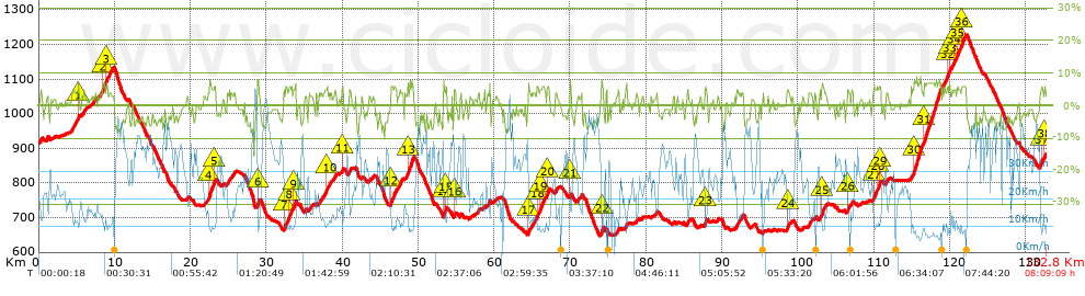
Distance in Km: 132.76
Climb in m: 2018
IBP: 136 BYC

Autor 19323
Author: Autor 19323
284 published routes

Add to my Group or Club

 Height in m      Climb in %      Speed in Km/h      Speed < 2 Km/h

Climbs > 5%

Climbs >5% Climbs >10% Climbs >15% Climbs >20% Climbs >25%
 Steep slope of 150 m.   Average slope  Distances  Download as waypoint
1
 Km 5.185  7%  150 m
 Steep slope of 256 m.  Average slope  Distances  Download as waypoint
2
 Km 8.418  7%  256 m
 Steep slope of 188 m.  Average slope  Distances  Download as waypoint
3
 Km 8.876  7%  188 m
 Steep slope of 599 m.  Average slope  Distances  Download as waypoint
4
 Km 22.363  6%  599 m
 Steep slope of 253 m.  Average slope  Distances  Download as waypoint
5
 Km 23.067  6%  253 m
 Steep slope of 197 m.  Average slope  Distances  Download as waypoint
6
 Km 28.834  8%  197 m
 Steep slope of 329 m.  Average slope  Distances  Download as waypoint
7
 Km 32.341  5%  329 m
 Steep slope of 433 m.  Average slope  Distances  Download as waypoint
8
 Km 32.963  6%  433 m
 Steep slope of 254 m.  Average slope  Distances  Download as waypoint
9
 Km 33.551  5%  254 m
 Steep slope of 213 m.  Average slope  Distances  Download as waypoint
10
 Km 37.826  5%  213 m
 Steep slope of 119 m.  Average slope  Distances  Download as waypoint
11
 Km 39.969  5%  119 m
 Steep slope of 662 m.  Average slope  Distances  Download as waypoint
12
 Km 46.395  6%  662 m
 Steep slope of 679 m.  Average slope  Distances  Download as waypoint
13
 Km 48.619  7%  679 m
 Steep slope of 106 m.  Average slope  Distances  Download as waypoint
14
 Km 53.321  9%  106 m
 Steep slope of 132 m.  Average slope  Distances  Download as waypoint
15
 Km 53.592  6%  132 m
 Steep slope of 117 m.  Average slope  Distances  Download as waypoint
16
 Km 54.794  5%  117 m
 Steep slope of 174 m.  Average slope  Distances  Download as waypoint
17
 Km 64.468  6%  174 m
 Steep slope of 225 m.  Average slope  Distances  Download as waypoint
18
 Km 65.628  6%  225 m
 Steep slope of 672 m.  Average slope  Distances  Download as waypoint
19
 Km 66.01  6%  672 m
 Steep slope of 312 m.  Average slope  Distances  Download as waypoint
20
 Km 66.916  6%  312 m
 Steep slope of 125 m.  Average slope  Distances  Download as waypoint
21
 Km 69.996  7%  125 m
 Steep slope of 225 m.  Average slope  Distances  Download as waypoint
22
 Km 74.135  7%  225 m
 Steep slope of 152 m.  Average slope  Distances  Download as waypoint
23
 Km 87.77  6%  152 m
 Steep slope of 106 m.  Average slope  Distances  Download as waypoint
24
 Km 98.63  6%  106 m
 Steep slope of 371 m.  Average slope  Distances  Download as waypoint
25
 Km 103.147  6%  371 m
 Steep slope of 209 m.  Average slope  Distances  Download as waypoint
26
 Km 106.537  5%  209 m
 Steep slope of 324 m.  Average slope  Distances  Download as waypoint
27
 Km 109.983  5%  324 m
 Steep slope of 156 m.  Average slope  Distances  Download as waypoint
28
 Km 110.411  5%  156 m
 Steep slope of 168 m.  Average slope  Distances  Download as waypoint
29
 Km 110.734  6%  168 m
 Steep slope of 1064 m.  Average slope  Distances  Download as waypoint
30
 Km 115.254  7%  1064 m
 Steep slope of 2255 m.  Average slope  Distances  Download as waypoint
31
 Km 116.613  7%  2255 m
 Steep slope of 192 m.  Average slope  Distances  Download as waypoint
32
 Km 119.618  6%  192 m
 Steep slope of 163 m.  Average slope  Distances  Download as waypoint
33
 Km 119.925  6%  163 m
 Steep slope of 163 m.  Average slope  Distances  Download as waypoint
34
 Km 120.511  5%  163 m
 Steep slope of 395 m.  Average slope  Distances  Download as waypoint
35
 Km 120.963  6%  395 m
 Steep slope of 576 m.  Average slope  Distances  Download as waypoint
36
 Km 121.54  6%  576 m
 Steep slope of 176 m.  Average slope  Distances  Download as waypoint
37
 Km 132.038  6%  176 m
 Steep slope of 120 m.  Average slope  Distances  Download as waypoint
38
 Km 132.502  6%  120 m


Description of the route


Presence of ramps


 Climbs  Distance  % of the total  Speed  Your speed would be  Time  Your time would be
   15 - 30%  0  0  0  ?  0:00:00  ?
   10 - 15%  0.075  0.06  9.58  ?  0:00:28  ?
   5 - 10%  14.019  10.56  10.01  ?  1:24:04  ?
   1 - 5%  38.795  29.22  16.45  ?  2:21:31  ?
   Total*  52.888 Km  39.84 %  14.04 Km/h  ? Km/h    3:46:03 h  ? h  
 Flat
   1 - -1%  28.434 Km  21.42 %  25.02 Km/h  ? Km/h    1:08:11 h  ? h  
 Descents
   -1 - -5%  36.405  27.42  32.5  ?  1:07:12  ?
   -5 - -10%  14.819  11.16  39.34  ?  0:22:36  ?
   -10 - -15%  0.178  0.13  30.51  ?  0:00:21  ?
   -15 - -30%  0.038  0.03  45.9  ?  0:00:03  ?
   Total*  51.44 Km  38.75 %  34.22 Km/h  ? Km/h    1:30:12 h  ? h  
* The total has not necessarily coincide with the sum of the partials after correction of errors

How long would it take you?

How long would it take you to cover this route?
There are routes without a valid time information, but with your average stats you can assess the possible duration

Autor 19323 to cover this route you've need a time of:   6:24:26 h 
If you sign in and have a minimum of two tracks of this same modality, you can know your time for this route, calculated from your stats..


¿Cuanto consumirá tu E-BIKE?

Entra tu E-IBP (formato n,nn)

E-IBP :   X 136 = 


 Detected activity type =  ()
 Penalization due to track conditions: 43 %   ( > 50 % = MTB, < 50 % = RDB)
 Reliability of the track: A   (2018/77/0/-/-/77)
 Correction level applied to the track: 0
DIFFICULTY OF THE ROUTE
IBP = 136 BYC
According to your statistics
 Your time in motion would be: ? h
Your average speed would be: ? Km/h
 

 Total Distance: 132.76 Km
 Analysed distance: 132.76 Km
 Linear distance: 81.67 Km

 Cumulated positive ramps: 2018.3 m  list of points info
 Cumulated negative ramps: 2043.2 m
 Maximum height: 1228.7 m
 Minimum height: 648 m
 Climbing Ratio: 3.82 %
 Descent ratio: 3.97 %
 Cumulated postive ramps per Km: 15.2 m
 Cumulated negative ramps per Km: 15.39 m

 Total time: 8:09:09 h
 Time in movement: 6:24:26 h
 According to your statistics
 Your time in motion would be: ? h  
 Stopped time: 1:44:43 h
 Maximum slope filter: ~30 %
 Minimum separation analysed: ~30 m
 Number of points: 5666   (cad. 23.43 m)
 Significant waypoints: 3086   (cad. 43.02 m / 54.47 %)

 Changes in direction per Km: 8.17
 Changes in direction > 5º por Km: 5.69
 Cumulated straight stretches: 29.559 Km
 Straight stretches per Km: 222.65 m
 Penalized slope changes: 18
 Penalized slope changes per Km: 0.136

 Average speed in total: 16.28 Km/h
 Average speed while moving: 20.72 Km/h
 According to your statistics
 Your average speed would be: ? Km/h  
 Maximum sustained speed: 62.46 Km/h


Comments

You can be the first one in commenting this route

 
My comments
:
Add comment  (Registered users)
 
Notify me answers to my comment  Do not notify answers to my comment


Share this route with a friend

Your friend will receive a message with a link to this page:
will see your email and your user name if you do it as registered user.


Write here your name (optional)

E-mail address of your friend(s). You can include various addresses separated by commas

Text or comment (optional) maximum 255 characters long, 255 Available characters

As a non registered users you need to fill-in the captcha text.
  Change image
Type the image characters.
 
 Share with a friend


Visited history

Delete history

Marked routes for review later or compare

My favorites


  Notify anomaly in this route Share in Facebook