Trialera de Las Carmelitas Serra-Portacoeli

MTB
MTB
Ref..: 1105384
Published: 05/06/2023
Performed: 04/06/2023
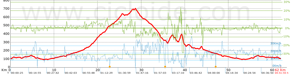
Distance in Km: 62
Climb in m: 1022
IBP: 69 BYC

Andres A.M.
Author: Andres A.M.
123 published routes

Add to my Group or Club

 Height in m      Climb in %      Speed in Km/h      Speed < 2 Km/h

Climbs > 5%

Climbs >5% Climbs >10% Climbs >15% Climbs >20% Climbs >25%
 Steep slope of 162 m.   Average slope  Distances  Download as waypoint
1
 Km 12.79  7%  162 m
 Steep slope of 187 m.  Average slope  Distances  Download as waypoint
2
 Km 16.924  6%  187 m
 Steep slope of 442 m.  Average slope  Distances  Download as waypoint
3
 Km 18.19  5%  442 m
 Steep slope of 941 m.  Average slope  Distances  Download as waypoint
4
 Km 18.999  7%  941 m
 Steep slope of 453 m.  Average slope  Distances  Download as waypoint
5
 Km 20.122  6%  453 m
 Steep slope of 123 m.  Average slope  Distances  Download as waypoint
6
 Km 20.839  5%  123 m
 Steep slope of 734 m.  Average slope  Distances  Download as waypoint
7
 Km 21.671  8%  415 m
8
 Km 22.086  11%  143 m
9
 Km 22.229  7%  176 m
 Steep slope of 179 m.  Average slope  Distances  Download as waypoint
10
 Km 23.006  5%  179 m
 Steep slope of 256 m.  Average slope  Distances  Download as waypoint
11
 Km 23.601  6%  256 m
 Steep slope of 215 m.  Average slope  Distances  Download as waypoint
12
 Km 24.39  6%  215 m
 Steep slope of 860 m.  Average slope  Distances  Download as waypoint
13
 Km 24.755  7%  860 m
 Steep slope of 264 m.  Average slope  Distances  Download as waypoint
14
 Km 27.257  8%  264 m
 Steep slope of 243 m.  Average slope  Distances  Download as waypoint
15
 Km 27.664  8%  243 m
 Steep slope of 140 m.  Average slope  Distances  Download as waypoint
16
 Km 28.492  8%  140 m
 Steep slope of 982 m.  Average slope  Distances  Download as waypoint
17
 Km 36.092  7%  36 m
18
 Km 36.128  12%  450 m
19
 Km 36.578  8%  496 m
 Steep slope of 686 m.  Average slope  Distances  Download as waypoint
20
 Km 38.495  6%  67 m
21
 Km 38.563  13%  204 m
22
 Km 38.767  14%  236 m
23
 Km 39.003  20%  33 m
24
 Km 39.036  10%  146 m
 Steep slope of 309 m.  Average slope  Distances  Download as waypoint
25
 Km 43.445  8%  309 m
 Steep slope of 196 m.  Average slope  Distances  Download as waypoint
26
 Km 55.762  6%  196 m


Description of the route


Presence of ramps


 Climbs  Distance  % of the total  Speed  Your speed would be  Time  Your time would be
   15 - 30%  0.306  0.49  5.86  ?  0:03:08  ?
   10 - 15%  0.97  1.56  10.3  ?  0:05:39  ?
   5 - 10%  6.511  10.5  13.72  ?  0:28:28  ?
   1 - 5%  16.42  26.48  16.93  ?  0:58:11  ?
   Total*  24.208 Km  39.04 %  15.22 Km/h  ? Km/h    1:35:26 h  ? h  
 Flat
   1 - -1%  15.476 Km  24.96 %  19.17 Km/h  ? Km/h    0:48:26 h  ? h  
 Descents
   -1 - -5%  15.026  24.24  22.16  ?  0:40:41  ?
   -5 - -10%  5.936  9.57  26.98  ?  0:13:12  ?
   -10 - -15%  0.582  0.94  12.78  ?  0:02:44  ?
   -15 - -30%  0.773  1.25  5.59  ?  0:08:18  ?
   Total*  22.318 Km  36 %  20.63 Km/h  ? Km/h    1:04:55 h  ? h  
* The total has not necessarily coincide with the sum of the partials after correction of errors

How long would it take you?

How long would it take you to cover this route?
There are routes without a valid time information, but with your average stats you can assess the possible duration

Andres A.M. to cover this route you've need a time of:   3:28:47 h 
If you sign in and have a minimum of two tracks of this same modality, you can know your time for this route, calculated from your stats..


¿Cuanto consumirá tu E-BIKE?

Entra tu E-IBP (formato n,nn)

E-IBP :   X 69 = 


 Detected activity type =  ()
 Penalization due to track conditions: 51 %   ( > 50 % = MTB, < 50 % = RDB)
 Reliability of the track: A   (1022/78/0/-/-/78)
 Correction level applied to the track: 0
DIFFICULTY OF THE ROUTE
IBP = 69 BYC
According to your statistics
 Your time in motion would be: ? h
Your average speed would be: ? Km/h
 

 Total Distance: 62 Km
 Analysed distance: 62 Km
 Linear distance: 0.02 Km

 Cumulated positive ramps: 1022.2 m  list of points info
 Cumulated negative ramps: 1022.2 m
 Maximum height: 704.5 m
 Minimum height: 91.3 m
 Climbing Ratio: 4.22 %
 Descent ratio: 4.58 %
 Cumulated postive ramps per Km: 16.49 m
 Cumulated negative ramps per Km: 16.49 m

 Total time: 4:51:55 h
 Time in movement: 3:28:47 h
 According to your statistics
 Your time in motion would be: ? h  
 Stopped time: 1:23:08 h
 Maximum slope filter: ~30 %
 Minimum separation analysed: ~30 m
 Number of points: 4925   (cad. 12.59 m)
 Significant waypoints: 1720   (cad. 36.05 m / 34.92 %)

 Changes in direction per Km: 10.65
 Changes in direction > 5º por Km: 7.03
 Cumulated straight stretches: 15.246 Km
 Straight stretches per Km: 245.9 m
 Penalized slope changes: 10
 Penalized slope changes per Km: 0.161

 Average speed in total: 12.74 Km/h
 Average speed while moving: 17.82 Km/h
 According to your statistics
 Your average speed would be: ? Km/h  
 Maximum sustained speed: 44.78 Km/h


Comments

You can be the first one in commenting this route

 
My comments
:
Add comment  (Registered users)
 
Notify me answers to my comment  Do not notify answers to my comment


Share this route with a friend

Your friend will receive a message with a link to this page:
will see your email and your user name if you do it as registered user.


Write here your name (optional)

E-mail address of your friend(s). You can include various addresses separated by commas

Text or comment (optional) maximum 255 characters long, 255 Available characters

As a non registered users you need to fill-in the captcha text.
  Change image
Type the image characters.
 
 Share with a friend


Visited history

Delete history

Marked routes for review later or compare

My favorites


  Notify anomaly in this route Share in Facebook