Santa Perpètua - Montserrat - Castellbell +14

MTB
MTB
Ref..: 1105320
Published: 04/06/2023
Performed: 03/06/2023
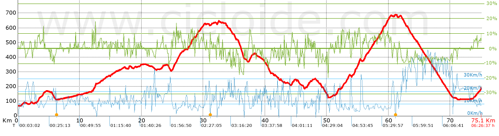
Distance in Km: 75.12
Climb in m: 1712
IBP: 124 BYC

Near ...
Florida, La, Llagosta, La, Mogoda, Mollet Del Valles, Santa Perpetua De Mogoda, Santiga (Santa Perpetua De Mogoda)
Juan Ramón
Author: Juan Ramón
341 published routes

Add to my Group or Club

 Height in m      Climb in %      Speed in Km/h      Speed < 2 Km/h

Climbs > 5%

Climbs >5% Climbs >10% Climbs >15% Climbs >20% Climbs >25%
 Steep slope of 147 m.   Average slope  Distances  Download as waypoint
1
 Km 0.634  5%  147 m
 Steep slope of 206 m.  Average slope  Distances  Download as waypoint
2
 Km 1.938  5%  206 m
 Steep slope of 295 m.  Average slope  Distances  Download as waypoint
3
 Km 3.226  8%  295 m
 Steep slope of 216 m.  Average slope  Distances  Download as waypoint
4
 Km 3.916  6%  216 m
 Steep slope of 406 m.  Average slope  Distances  Download as waypoint
5
 Km 12.203  7%  263 m
6
 Km 12.466  11%  75 m
7
 Km 12.541  18%  68 m
 Steep slope of 159 m.  Average slope  Distances  Download as waypoint
8
 Km 13.24  5%  159 m
 Steep slope of 132 m.  Average slope  Distances  Download as waypoint
9
 Km 13.751  5%  132 m
 Steep slope of 99 m.  Average slope  Distances  Download as waypoint
10
 Km 17.939  12%  99 m
 Steep slope of 247 m.  Average slope  Distances  Download as waypoint
11
 Km 23.301  6%  247 m
 Steep slope of 626 m.  Average slope  Distances  Download as waypoint
12
 Km 24.884  5%  230 m
13
 Km 25.114  10%  97 m
14
 Km 25.212  10%  299 m
 Steep slope of 658 m.  Average slope  Distances  Download as waypoint
15
 Km 25.63  13%  99 m
16
 Km 25.729  8%  115 m
17
 Km 25.843  8%  138 m
18
 Km 25.981  9%  306 m
 Steep slope of 134 m.  Average slope  Distances  Download as waypoint
19
 Km 26.435  6%  134 m
 Steep slope of 686 m.  Average slope  Distances  Download as waypoint
20
 Km 27.504  7%  539 m
21
 Km 28.043  13%  147 m
 Steep slope of 275 m.  Average slope  Distances  Download as waypoint
22
 Km 28.22  7%  78 m
23
 Km 28.298  5%  197 m
 Steep slope of 516 m.  Average slope  Distances  Download as waypoint
24
 Km 28.742  7%  365 m
25
 Km 29.107  13%  106 m
26
 Km 29.213  8%  45 m
 Steep slope of 173 m.  Average slope  Distances  Download as waypoint
27
 Km 29.592  7%  173 m
 Steep slope of 152 m.  Average slope  Distances  Download as waypoint
28
 Km 30.032  7%  152 m
 Steep slope of 232 m.  Average slope  Distances  Download as waypoint
29
 Km 32.273  7%  232 m
 Steep slope of 424 m.  Average slope  Distances  Download as waypoint
30
 Km 37.427  7%  91 m
31
 Km 37.517  9%  116 m
32
 Km 37.633  10%  217 m
 Steep slope of 103 m.  Average slope  Distances  Download as waypoint
33
 Km 43.06  5%  103 m
 Steep slope of 183 m.  Average slope  Distances  Download as waypoint
34
 Km 44.304  8%  183 m
 Steep slope of 119 m.  Average slope  Distances  Download as waypoint
35
 Km 44.628  7%  119 m
 Steep slope of 316 m.  Average slope  Distances  Download as waypoint
36
 Km 46.769  7%  316 m
 Steep slope of 102 m.  Average slope  Distances  Download as waypoint
37
 Km 47.552  6%  102 m
 Steep slope of 475 m.  Average slope  Distances  Download as waypoint
38
 Km 51.379  5%  217 m
39
 Km 51.596  9%  141 m
40
 Km 51.737  9%  117 m
 Steep slope of 345 m.  Average slope  Distances  Download as waypoint
41
 Km 52.538  8%  345 m
 Steep slope of 360 m.  Average slope  Distances  Download as waypoint
42
 Km 53.134  8%  178 m
43
 Km 53.312  9%  109 m
44
 Km 53.422  11%  73 m
 Steep slope of 114 m.  Average slope  Distances  Download as waypoint
45
 Km 53.614  12%  114 m
 Steep slope of 153 m.  Average slope  Distances  Download as waypoint
46
 Km 54.067  7%  153 m
 Steep slope of 369 m.  Average slope  Distances  Download as waypoint
47
 Km 54.379  9%  179 m
48
 Km 54.558  10%  190 m
 Steep slope of 559 m.  Average slope  Distances  Download as waypoint
49
 Km 54.852  8%  247 m
50
 Km 55.099  13%  312 m
 Steep slope of 522 m.  Average slope  Distances  Download as waypoint
51
 Km 55.826  7%  522 m
 Steep slope of 1038 m.  Average slope  Distances  Download as waypoint
52
 Km 56.753  7%  1038 m
 Steep slope of 1146 m.  Average slope  Distances  Download as waypoint
53
 Km 58.185  7%  884 m
54
 Km 59.069  10%  178 m
55
 Km 59.248  8%  84 m
 Steep slope of 799 m.  Average slope  Distances  Download as waypoint
56
 Km 59.506  8%  799 m
 Steep slope of 104 m.  Average slope  Distances  Download as waypoint
57
 Km 60.95  7%  104 m
 Steep slope of 430 m.  Average slope  Distances  Download as waypoint
58
 Km 73.903  5%  430 m
 Steep slope of 130 m.  Average slope  Distances  Download as waypoint
59
 Km 74.478  5%  130 m
 Steep slope of 185 m.  Average slope  Distances  Download as waypoint
60
 Km 74.736  6%  185 m


Description of the route


Presence of ramps


 Climbs  Distance  % of the total  Speed  Your speed would be  Time  Your time would be
   15 - 30%  0.389  0.52  5.85  ?  0:03:59  ?
   10 - 15%  3.583  4.77  7.34  ?  0:29:18  ?
   5 - 10%  12.245  16.3  9.07  ?  1:20:58  ?
   1 - 5%  11.364  15.13  11.31  ?  1:00:17  ?
   Total*  27.581 Km  36.72 %  9.48 Km/h  ? Km/h    2:54:32 h  ? h  
 Flat
   1 - -1%  22.249 Km  29.62 %  14.71 Km/h  ? Km/h    1:30:46 h  ? h  
 Descents
   -1 - -5%  8.166  10.87  19  ?  0:25:47  ?
   -5 - -10%  14.93  19.87  25.85  ?  0:34:39  ?
   -10 - -15%  1.7  2.26  15.49  ?  0:06:35  ?
   -15 - -30%  0.496  0.66  12.15  ?  0:02:27  ?
   Total*  25.292 Km  33.67 %  21.85 Km/h  ? Km/h    1:09:28 h  ? h  
* The total has not necessarily coincide with the sum of the partials after correction of errors

How long would it take you?

How long would it take you to cover this route?
There are routes without a valid time information, but with your average stats you can assess the possible duration

Juan Ramón to cover this route you've need a time of:   5:34:46 h 
If you sign in and have a minimum of two tracks of this same modality, you can know your time for this route, calculated from your stats..


¿Cuanto consumirá tu E-BIKE?

Entra tu E-IBP (formato n,nn)

E-IBP :   X 124 = 


 Detected activity type =  ()
 Penalization due to track conditions: 66 %   ( > 50 % = MTB, < 50 % = RDB)
 Reliability of the track: A   (1712/85/0/-/-/85)
 Correction level applied to the track: 0
DIFFICULTY OF THE ROUTE
IBP = 124 BYC
According to your statistics
 Your time in motion would be: ? h
Your average speed would be: ? Km/h
 

 Total Distance: 75.12 Km
 Analysed distance: 75.12 Km
 Linear distance: 28.26 Km

 Cumulated positive ramps: 1711.8 m  list of points info
 Cumulated negative ramps: 1592.6 m
 Maximum height: 687.8 m
 Minimum height: 65.8 m
 Climbing Ratio: 6.21 %
 Descent ratio: 6.3 %
 Cumulated postive ramps per Km: 22.79 m
 Cumulated negative ramps per Km: 21.2 m

 Total time: 6:26:37 h
 Time in movement: 5:34:46 h
 According to your statistics
 Your time in motion would be: ? h  
 Stopped time: 0:51:51 h
 Maximum slope filter: ~30 %
 Minimum separation analysed: ~30 m
 Number of points: 4280   (cad. 17.55 m)
 Significant waypoints: 1877   (cad. 40.02 m / 43.86 %)

 Changes in direction per Km: 10.22
 Changes in direction > 5º por Km: 7.85
 Cumulated straight stretches: 11.397 Km
 Straight stretches per Km: 151.72 m
 Penalized slope changes: 15
 Penalized slope changes per Km: 0.2

 Average speed in total: 11.66 Km/h
 Average speed while moving: 13.46 Km/h
 According to your statistics
 Your average speed would be: ? Km/h  
 Maximum sustained speed: 55.54 Km/h


Comments

You can be the first one in commenting this route

 
My comments
:
Add comment  (Registered users)
 
Notify me answers to my comment  Do not notify answers to my comment


Share this route with a friend

Your friend will receive a message with a link to this page:
will see your email and your user name if you do it as registered user.


Write here your name (optional)

E-mail address of your friend(s). You can include various addresses separated by commas

Text or comment (optional) maximum 255 characters long, 255 Available characters

As a non registered users you need to fill-in the captcha text.
  Change image
Type the image characters.
 
 Share with a friend


Visited history

Delete history

Marked routes for review later or compare

My favorites


  Notify anomaly in this route Share in Facebook