RUTA HECHA CON NIEBLA Y VIENTO FRIO, NO PUDIMOS VER NADA EXCEPTO EN PEĐA NEGRILLA Y LA BAJADA
DISTANCIA: 16,56 km.
TIEMPO: 8 h. 4 min. (6 h. 17 min. en movimiento con paradas).
VELOCIDAD MEDIA: 2,05 km/h. (Con paradas).
DESNIVEL SUBIDO: 1113,69 metros.
DESNIVEL BAJADO: 1092,59 metros.
RATIO DE SUBIDA: 11,61 %/km.
RATIO DE BAJADA: 16,8 %/km.
DIFICULTAD: Moderado. (Depende condiciˇn fÝsica de cada uno).
MATERIAL: Senderismo.
TIPO DE RUTA: Circular.
TERRENO: Senderos, senderos con hitos, pedreras.
INDICE DE ESFUERZO: 123 HKG. MUY DURA. (Condiciˇn FÝsica Media). "Ver tabla mßs abajo".
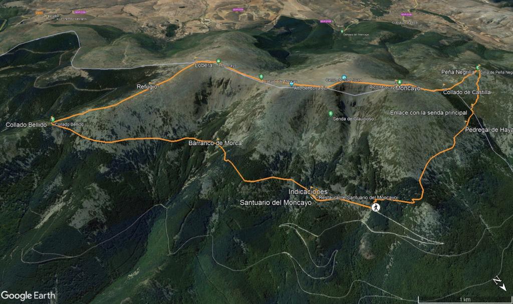
Salimos del parking de Haya Seca que es el ˙ltimo parking de uso p˙blico tras haber subido por la pista hasta Úl y seguimos a pie hasta el Santuario del Moncayo que estarß unos 500 metros mßs arriba, atravesamos la barrera para los coches y seguiremos el sendero que sale enfrente, un cartel explicativo te indica la ruta "clasica" pero nosotros la haremos circular, pues bien subimos por el GR-90 dejando a mano derecha la subida "clasica", mßs dura y mßs corta para otra ocasiˇn, vamos subiendo suavemente por el sendero entre un bosque de pinos, el sendero es bastante llevadero y avanzaremos rßpidamente por Úl, bajamos suavemente tambiÚn cruzando el Barranco de Morca y su pedrera para despuÚs ir subiendo sin esfuerzo hasta el Collado Bellido (1814 m) tras 4,4 km en apenas 1 hora de camino, aquÝ giramos a la derecha abandonando el GR-90 y subimos por un sendero que no ofrece mucha resistencia, pasaremos por un chozo o refugio de pastores y en nada la cima del Lobera (2226 m).
Seguiremos el sendero girando a la derecha y descenderemos suavemente hasta llegar al Collado de Morca para despuÚs subir progresivamente hasta el enlace con la subida "clasica" que dejamos a la derecha y seguiremos a la izquierda, pasando por el Cerro San Juan (2282 m) y por el Collado de las Piedras para unos metros mßs arriba (unos 150) llegar hasta el Moncayo o San Miguel (2314 m), como estabamos con niebla no pudimos ver las preciosas vistas.
Seguimos nuestro sendero bajando por una empinada pedrera (bajaremos unos 350 metros en apenas 1 km) que estß perfectamente se˝alizada y no ofrece mucha resistencia eso si cuidado a cualquier resbalˇn. Tras esta bajada llegaremos al Collado de Castilla (1950 m), seguiremos el sendero enfrente y ascenderemos ya un poco cansados y con una buena pendiente hasta el ˙ltimo del dÝa Pe˝a Negrilla (2118 m) o tambiÚn llamado Moncayo de Castilla (por estar ya en tierras Castellano-Leonesas).
Tras coronar este ˙ltimo pico y poder disfrutar un poco de las vistas esta vez si, procedemos a bajar por otro sitio en vez del que hemos subido (recomiendo bajar por la subida), en los mapas viene un sendero que se llama Senda a la Pe˝a San Miguel, bien pues nos disponemos a bajar por Úl en fuerte pendiente y por una buena pedrera, decir que no existen hitos ninguno por lo que bajamos por dˇnde lo vimos mejor, hasta ya conseguir enlazar con la senda que baja desde el Collado de Castilla nos llevˇ un buen rato.
Enlzamos con este sendero y en unos metros mßs abajo vemos un gran hito, giramos a la derecha y bajamos en suave descenso por el pinar, mßs adelante llegamos a la pedrera del Barranco de Agramonte que se atraviesa sin problemas ya que estß muy pisada y no ofrece resistencia, subiremos muy ligeramente para despuÚs bajar tambiÚn ligeramente y atravesar el Barranco de Haya seca y de ahÝ llegar hasta el parking del mismo nombre dando por finalizada tan buena ruta.
Nos vemos en las Monta˝as!!. |

 Not from STRAVA
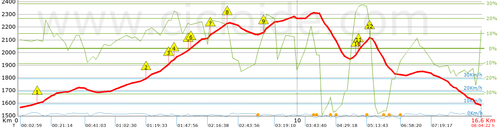


 list of points info

