Ruta incompleta por la cantidad de nieve acumulada, la ruta es la misma buscando fortificaciones por el Prado Toril que no bajaremos a el, ya la haremos m�s adelante con terreno m�s despejado
DISTANCIA: 11,67 km.
TIEMPO: 5 h. 21 min. (4 h. 9 min. en movimiento con paradas).
VELOCIDAD MEDIA: 2,18 km/h.
DESNIVEL SUBIDO: 680,74 metros.
DESNIVEL BAJADO: 660,84 metros.
PORCENTAJE SUBIDA: 14,09 %/km.
PORCENTAJE BAJADA: 10,64 %/km.
DIFICULTAD: Moderado (por la nieve).
MATERIAL: Senderismo, crampones.
TERRENO: Pista, carretera, senderos, senderos con hitos.
INDICE DE ESFUERZO: 77 HKG. DURA. (Condici�n F�sica Media) "Ver tabla abajo".
Agradecimientos a Lhiguer por la ruta aunque no fuimos a buscar las Fortificaciones del Prado Toril por la nieve (para otra ocasi�n).
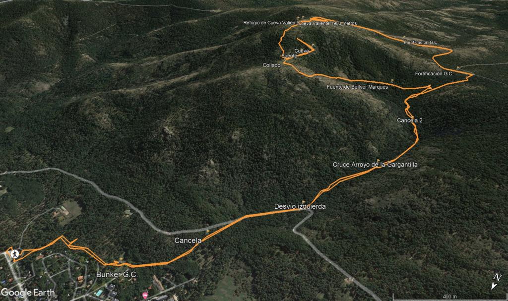
Salimos del parking d�nde se ubica la plaza de Toros un poco m�s arriba del Campo de Futbol, subimos a la derecha pegados al murete de las casas y pronto divisamos una peque�a construcci�n o fortificaci�n de la Guerra Civil (o parece), seguimos un sendero enfrente y nos vamos alejando de San Rafael dej�ndolo al margen derecho, enseguida atravesamos una cancela y subimos por un ancho sendero hasta una carretera en la cu�l tambi�n puedes subir en coche, la cogemos a mano derecha y avanzamos unos 100 metros, antes de llegar al puente giramos a mano izquierda y cogemos el sendero que discurre paralelo al Arroyo de la Gargantilla, subiendo suavemente durante casi 1 km, giramos a mano izquierda para coger otro sendero, pasando previamente por la Fuente de Bellver Marqu�s, a partir de aqu� empieza a acumularse un buen desnivel, llegamos a una especie de Collado, despu�s giramos a la derecha en busca del sendero que nos llevar� a la Cueva, lo encontramos sin complicaciones, pasamos por delante de la Fuente de la Cueva y tras unos 100 metros giramos a la izquierda para acceder a la Cueva con una f�cil trepada, aunque hay nieve y hielo la realizamos sin ning�n problema, parada para un tentempi�.
Despu�s de la pausa desandamos el camino, volvemos al Collado y giramos a la derecha, una fuerte pendiente nos espera y m�s con nieve lo cu�l dificulta el encontrar bien el camino que en condiciones normales es ancho y bien marcado, son unos 600 metros que nos sacar� un poco de punto pero alcanzamos el geod�sico de Cueva Valiente (1903 m) y su refugio un poco m�s abajo, entramos en el mismo para entrar un poco en calor y retomamos la ruta ya bajando por la carretera suavemente, dejando el Cerro Valiente a mano izquierda y contemplando alguna que otra fortificaci�n a mano izquierda tambi�n de la Guerra Civil, en la ruta de Lhiguer unos metros m�s abajo se desv�a a mano izquierda en direcci�n al Prado Toril pero nosotros con la acumulaci�n de nieve no bajamos a investigar (para cuando haga mejor y est� todo m�s despejado) las fortificaciones restantes algo que tienen que ser espectaculares sino que seguimos descendiendo suavemente por la carretera de Peguerinos hasta llegar al Collado de la Gargantilla, d�nde se cruzan varios caminos, cogemos el de m�s a la derecha, pasando por la Fuente de Juan Bellver y descendiendo por el sendero y pegado al Arroyo de la Gargantilla hasta el cruce de caminos d�nde vimos la otra fuente, seguimos enfrente y enlazamos el camino de ida todo ello pegado al Arroyo de la Gargantilla, llegamos al puente y la carretera y desandamos el camino de la ida hasta los coches.
Nos vemos en las Monta�as!!.
|

 Not from STRAVA
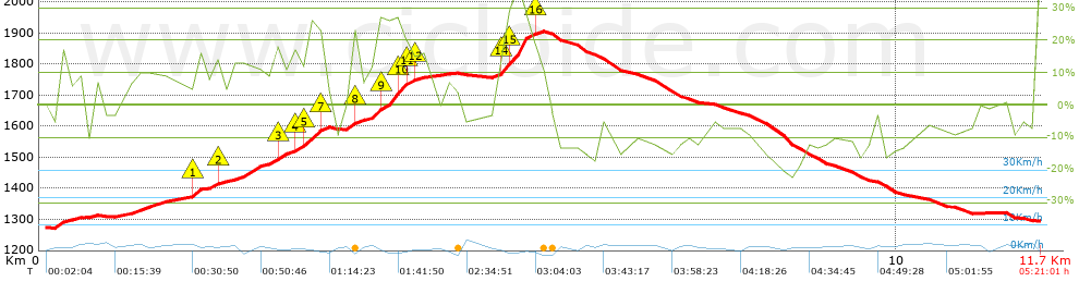


 list of points info

