Triangulando _

Road
Road
Ref..: 1085117
Published: 15/01/2023
Performed: 14/01/2023
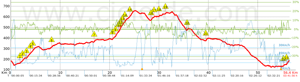
Distance in Km: 56.4
Climb in m: 881
IBP: 46 BYC

Near ...
Aspera (San Cibrao Das Viñas), Astres, Barreiros Zona Comercial, Beiro (Ourense), Bemposta (Ourense), Bouza, A (Ourense)
Endoureiro
Author: Endoureiro
348 published routes

Add to my Group or Club

 Height in m      Climb in %      Speed in Km/h      Speed < 2 Km/h

Climbs > 5%

Climbs >5% Climbs >10% Climbs >15% Climbs >20% Climbs >25%
 Steep slope of 139 m.   Average slope  Distances  Download as waypoint
1
 Km 1.902  5%  139 m
 Steep slope of 340 m.  Average slope  Distances  Download as waypoint
2
 Km 2.395  5%  340 m
 Steep slope of 559 m.  Average slope  Distances  Download as waypoint
3
 Km 3.204  6%  559 m
 Steep slope of 297 m.  Average slope  Distances  Download as waypoint
4
 Km 4  5%  297 m
 Steep slope of 381 m.  Average slope  Distances  Download as waypoint
5
 Km 4.42  6%  381 m
 Steep slope of 241 m.  Average slope  Distances  Download as waypoint
6
 Km 8.213  5%  241 m
 Steep slope of 171 m.  Average slope  Distances  Download as waypoint
7
 Km 16.908  7%  171 m
 Steep slope of 236 m.  Average slope  Distances  Download as waypoint
8
 Km 20.61  6%  236 m
 Steep slope of 400 m.  Average slope  Distances  Download as waypoint
9
 Km 21.17  9%  400 m
 Steep slope of 613 m.  Average slope  Distances  Download as waypoint
10
 Km 21.742  7%  248 m
11
 Km 21.989  10%  204 m
12
 Km 22.194  9%  161 m
 Steep slope of 394 m.  Average slope  Distances  Download as waypoint
13
 Km 22.551  7%  394 m
 Steep slope of 402 m.  Average slope  Distances  Download as waypoint
14
 Km 23.069  7%  402 m
 Steep slope of 791 m.  Average slope  Distances  Download as waypoint
15
 Km 24.029  7%  791 m
 Steep slope of 309 m.  Average slope  Distances  Download as waypoint
16
 Km 28.409  7%  309 m
 Steep slope of 126 m.  Average slope  Distances  Download as waypoint
17
 Km 28.924  5%  126 m
 Steep slope of 135 m.  Average slope  Distances  Download as waypoint
18
 Km 30.003  6%  135 m
 Steep slope of 193 m.  Average slope  Distances  Download as waypoint
19
 Km 31.296  6%  193 m
 Steep slope of 268 m.  Average slope  Distances  Download as waypoint
20
 Km 35.648  7%  268 m
 Steep slope of 332 m.  Average slope  Distances  Download as waypoint
21
 Km 39.465  6%  332 m
 Steep slope of 176 m.  Average slope  Distances  Download as waypoint
22
 Km 55.142  6%  176 m
 Steep slope of 371 m.  Average slope  Distances  Download as waypoint
23
 Km 55.796  8%  371 m


Description of the route


Presence of ramps


 Climbs  Distance  % of the total  Speed  Your speed would be  Time  Your time would be
   15 - 30%  0.041  0.07  7.41  ?  0:00:20  ?
   10 - 15%  0.385  0.68  7.71  ?  0:03:00  ?
   5 - 10%  7.125  12.63  10.48  ?  0:40:48  ?
   1 - 5%  13.783  24.44  15.56  ?  0:53:08  ?
   Total*  21.334 Km  37.83 %  13.16 Km/h  ? Km/h    1:37:16 h  ? h  
 Flat
   1 - -1%  12.734 Km  22.58 %  23.27 Km/h  ? Km/h    0:32:50 h  ? h  
 Descents
   -1 - -5%  15.282  27.09  30.73  ?  0:29:50  ?
   -5 - -10%  6.942  12.31  46.71  ?  0:08:55  ?
   -10 - -15%  0.109  0.19  65.57  ?  0:00:06  ?
   -15 - -30%  0  0  0  ?  0:00:00  ?
   Total*  22.333 Km  39.6 %  34.49 Km/h  ? Km/h    0:38:51 h  ? h  
* The total has not necessarily coincide with the sum of the partials after correction of errors

How long would it take you?

How long would it take you to cover this route?
There are routes without a valid time information, but with your average stats you can assess the possible duration

Endoureiro to cover this route you've need a time of:   2:48:57 h 
If you sign in and have a minimum of two tracks of this same modality, you can know your time for this route, calculated from your stats..


¿Cuanto consumirá tu E-BIKE?

Entra tu E-IBP (formato n,nn)

E-IBP :   X 46 = 


 Detected activity type =  ()
 Penalization due to track conditions: 35 %   ( > 50 % = MTB, < 50 % = RDB)
 Reliability of the track: B   (880/67/0/-/-/67)
 Correction level applied to the track: 0
DIFFICULTY OF THE ROUTE
IBP = 46 BYC
According to your statistics
 Your time in motion would be: ? h
Your average speed would be: ? Km/h
 

 Total Distance: 56.4 Km
 Analysed distance: 56.4 Km
 Linear distance: 0.03 Km

 Cumulated positive ramps: 880.6 m  list of points info
 Cumulated negative ramps: 887.8 m
 Maximum height: 658.7 m
 Minimum height: 125.7 m
 Climbing Ratio: 4.13 %
 Descent ratio: 3.98 %
 Cumulated postive ramps per Km: 15.61 m
 Cumulated negative ramps per Km: 15.74 m

 Total time: 3:41:56 h
 Time in movement: 2:48:57 h
 According to your statistics
 Your time in motion would be: ? h  
 Stopped time: 0:52:59 h
 Maximum slope filter: ~30 %
 Minimum separation analysed: ~30 m
 Number of points: 2292   (cad. 24.61 m)
 Significant waypoints: 1302   (cad. 43.32 m / 56.81 %)

 Changes in direction per Km: 6.95
 Changes in direction > 5º por Km: 4.24
 Cumulated straight stretches: 19.322 Km
 Straight stretches per Km: 342.59 m
 Penalized slope changes: 9
 Penalized slope changes per Km: 0.16

 Average speed in total: 15.25 Km/h
 Average speed while moving: 20.03 Km/h
 According to your statistics
 Your average speed would be: ? Km/h  
 Maximum sustained speed: 74.85 Km/h


Comments

You can be the first one in commenting this route

 
My comments
:
Add comment  (Registered users)
 
Notify me answers to my comment  Do not notify answers to my comment


Share this route with a friend

Your friend will receive a message with a link to this page:
will see your email and your user name if you do it as registered user.


Write here your name (optional)

E-mail address of your friend(s). You can include various addresses separated by commas

Text or comment (optional) maximum 255 characters long, 255 Available characters

As a non registered users you need to fill-in the captcha text.
  Change image
Type the image characters.
 
 Share with a friend


Visited history

Delete history

Marked routes for review later or compare

My favorites


  Notify anomaly in this route Share in Facebook