332.Cabeza Lijar (1823 m) express

Hiking
Hiking
Ref..: 1084304
Published: 08/01/2023
Performed: 24/12/2022
Distance in Km: 9.45
Climb in m: 396
IBP: 61 HKG

Carlos Plaza Esteban
260 published routes

Add to my Group or Club

 Height in m      Climb in %      Speed in Km/h      Speed < 2 Km/h


Description of the route

DISTANCIA: 9,45 km.
TIEMPO: 2 h. 58 min. (2 h. 29 min. en movimiento con paradas).
VELOCIDAD MEDIA: 3,17 km/h.
DESNIVEL SUBIDO: 396,3 metros.
DESNIVEL BAJADO: 405,1 metros.
PORCENTAJE SUBIDA: 10,45 %/km.
PORCENTAJE BAJADA: 8,47 %/km.
DIFICULTAD: Fácil.
MATERIAL: Senderismo.
TERRENO: Pistas, senderos.
INDICE DE ESFUERZO: 61 HKG. MEDIA. (Condición Física Media).

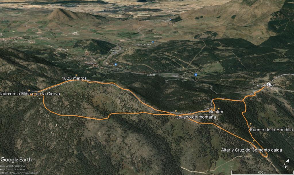
Una ruta corta y no demasiado exigente. Comienza en el mismo puerto de los Leones. Salimos por un camino detrás del asador. Una pequeña cuesta y a nuestra izquierda podemos ver un panel informativo, con las diversas zonas marcadas que existen en la zona. Yo opte, por la senda azul, de subida a Cabeza Lijar, con una pequeña variante de vuelta. Vemos unos carteles indicadores a Peguerinos, seguimos y vemos unas torres de comunicaciones. Y pasado un paso canadiense, nos encontramos nuestro desvió a la derecha. También vamos a seguir durante un buen tramo el GR 10. En este punto de frente sigue la senda de color rosa, de los Álamos Blancos, por donde luego regresaremos.

Comienza una subida al Cerro Piñonero, entre pinares, veremos varios paneles informativos a lo largo de la ruta y un bunker, desde podremos tener unas magnificas vistas en lo alto del Cerro Piñonero a la izquierda. Regresamos de nuevo y a nuestra derecha un bunker en ruinas, desde donde podemos ver Cueva Valiente y el Cabeza Lijar esperándonos. Seguimos por las marcas del GR 10 y marcas azules. Hasta llegar al Collado de la Gasca, donde tendremos que cruzar por una puerta al lado Segoviano. Aquí comienza la subida a Cabeza Lijar, unos tramos con piedras, pero en general y tomándolo con calma, sin grandes dificultades ascenderemos hasta la cima dónde disfrutaremos de unas preciosas vistas.

Comenzamos a bajar, pasamos la valla y seguiremos las marcas, aunque en este tramo, se pierden un poco, pero no hay perdida hay que bajar mas o menos cercanos a la valla a nuestra izquierda. Abajo del todo, esta el Collado de la Mina. Es un cruce de caminos, justo delante de nosotros a la izquierda sube una senda al Cerro de Salamanca, lugar de inicio del GR 88. De frente iríamos hacia el Collado de la Gargantilla. En este punto hacemos un giro de a nuestra izquierda, para tomar la pista que nos llevará directamente a el Puerto de los Leones en bajada. A su paso nos encontraremos con la ruta de los Álamos Blancos y una fuente, enlazamos más adelante con la pista de ida y de ahí llegaremos a los coches.

Nos vemos en las Montañas!!.


Presence of ramps


 Climbs  Distance  % of the total  Speed  Your speed would be  Time  Your time would be
   15 - 30%  1.069  11.31  2.43  ?  0:26:23  ?
   10 - 15%  0.464  4.91  3.24  ?  0:08:36  ?
   5 - 10%  1.161  12.29  3.39  ?  0:20:33  ?
   1 - 5%  1.099  11.64  3.34  ?  0:19:44  ?
   Total*  3.793 Km  40.15 %  3.02 Km/h  ? Km/h    1:15:16 h  ? h  
 Flat
   1 - -1%  0.957 Km  10.13 %  5.13 Km/h  ? Km/h    0:11:12 h  ? h  
 Descents
   -1 - -5%  1.169  12.37  5.14  ?  0:13:38  ?
   -5 - -10%  2.051  21.71  4.85  ?  0:25:22  ?
   -10 - -15%  0.773  8.19  4.84  ?  0:09:35  ?
   -15 - -30%  0.703  7.44  2.97  ?  0:14:13  ?
   Total*  4.696 Km  49.71 %  4.49 Km/h  ? Km/h    1:02:48 h  ? h  
* The total has not necessarily coincide with the sum of the partials after correction of errors

How long would it take you?

How long would it take you to cover this route?
There are routes without a valid time information, but with your average stats you can assess the possible duration

Carlos Plaza Esteban to cover this route you've need a time of:   2:29:16 h 
If you sign in and have a minimum of two tracks of this same modality, you can know your time for this route, calculated from your stats..


 Detected activity type =  ()
 Penalization due to track conditions: 0 %   ( > 50 % = MTB, < 50 % = RDB)
 Reliability of the track: A   (396/84/0/-/-/84)
 Correction level applied to the track: 0
DIFFICULTY OF THE ROUTE
IBP = 61 HKG
According to your statistics
 Your time in motion would be: ? h
Your average speed would be: ? Km/h
 

 Total Distance: 9.45 Km
 Analysed distance: 9.45 Km
 Linear distance: 0.01 Km

 Cumulated positive ramps: 396.26 m  list of points info
 Cumulated negative ramps: 404.29 m
 Maximum height: 1820.25 m
 Minimum height: 1509.7 m
 Climbing Ratio: 10.45 %
 Descent ratio: 8.61 %
 Cumulated postive ramps per Km: 41.93 m
 Cumulated negative ramps per Km: 42.78 m

 Total time: 2:58:32 h
 Time in movement: 2:29:16 h
 According to your statistics
 Your time in motion would be: ? h  
 Stopped time: 0:29:16 h
 Maximum slope filter: ~55 %
 Minimum separation analysed: ~30 m
 Number of points: 107   (cad. 88.27 m)
 Significant waypoints: 94   (cad. 100.48 m / 87.85 %)

 Changes in direction per Km: 6.46
 Changes in direction > 5º por Km: 6.46
 Cumulated straight stretches: 0.075 Km
 Straight stretches per Km: 7.94 m
 Penalized slope changes: 4
 Penalized slope changes per Km: 0.423

 Average speed in total: 3.17 Km/h
 Average speed while moving: 3.8 Km/h
 According to your statistics
 Your average speed would be: ? Km/h  
 Maximum sustained speed: 5.74 Km/h


Comments

You can be the first one in commenting this route

 
My comments
:
Add comment  (Registered users)
 
Notify me answers to my comment  Do not notify answers to my comment


Share this route with a friend

Your friend will receive a message with a link to this page:
will see your email and your user name if you do it as registered user.


Write here your name (optional)

E-mail address of your friend(s). You can include various addresses separated by commas

Text or comment (optional) maximum 255 characters long, 255 Available characters

As a non registered users you need to fill-in the captcha text.
  Change image
Type the image characters.
 
 Share with a friend


Visited history

Delete history

Marked routes for review later or compare

My favorites


  Notify anomaly in this route Share in Facebook