DISTANCIA: 20,84 km.
TIEMPO: 7 h. 13 min. (5 h. 10 min. en movimiento).
VELOCIDAD MEDIA: 2,89 km/h.
DESNIVEL SUBIDO: 936.1 metros.
DESNIVEL BAJADO: 922.6 metros.
PORCENTAJE SUBIDA: 10,02 %/km.
PORCENTAJE BAJADA: 9,18 %/km.
DIFICULTAD: Moderado.
MATERIAL: Senderismo.
TERRENO: Pista, Senderos, Cortafuegos.
INDICE DE ESFUERZO: 100 HKG. DURA. (Condici¾n FĒsica Media).
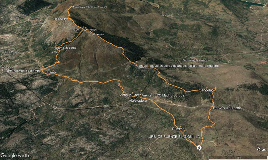
Aparcamos a un par de kms de Lozoyuela por la carretera M-988 que va a la antigua estaci¾n/apeadero y tomamos una pista con la indicaci¾n al Valle del Lozoya por el Cordel de Lozoyuela, para tomar la Loma de Mata ┴guila que sube desde El Cuadr¾n, y que nos a a subir a Pe±a Negra, todo ello mediante pista ancha, en este punto nos encontramos con la divisoria de Lozoyuela y Garganta de los Montes mediante un vallado que nos acompa±arß toda la subida, al principio dejßndolo a nuestra derecha, para luego situarla definitivamente a nuestra izquierda, a la tercera puerta metßlica dejamos el vallado a nuestra izquierda y subimos pegados a ķl, para tomar un poco mßs adelante un cortafuegos que de forma directa por el cordal nos subirß a Pe±a Negra. Es el tramo mßs exigente de toda la ruta, y son 300 metros de subida casi directa por lo que habrß que estar preparado fĒsicamente, ya que la rampa media es del 30%, llegamos a un peque±o descansillo, tomando una peque±a pista a mano derecha para subir mßs suavemente hasta encontrarnos con el ·ltimo cortafuegos aunque es mßs corto para acceder a unas primera antenas y despuķs seguir el sendero que nos conducirß a la Pe±a Negra (1832 metros) tambiķn con unas antenas pegadas a su cima. Desde la cima, contemplamos la sierra Norte, en la vertiente del valle de Lozoya, los embalses de Riosequillo y del Atazar, la Sierra de la Cabrera. MagnĒficas vistas. La visi¾n de Valdemanco debajo de nosotros es increĒble.
Procedemos acto seguido a seguir el cordal a mano derecha por sendero perfectamente definido hasta el Mondalindo o Cabezo del Cervunal (1831 metros) que alcanzamos en aproximadamente 1,5 km tras bajar a un peque±o collado y subir suavemente hasta su geodķsico.Volvemos sobre nuestros pasos de vuelta otra vez a la Pe±a Negra, pasamos por delante de ella y descendemos a la altura de las primeras antenas, despuķs tomaremos un sendero a mano derecha que es bastante pronunciado por bosque que nos bajarß hasta el Puerto de Medio CelemĒn, bajamos del Puerto por una pista y nos encontramos con la vĒa del Ferrocarril Madrid-Burgos, hoy en desuso. Continuamos nuestro camino por la ruta se±alizada y ahora nos encontramos con los restos de un grande, robusto, s¾lido edificio, con gruesos muros y una altura considerable pero en ruinas: una Antigua Cßrcel. Ya s¾lo nos quedan unos pocos kil¾metros hasta nuestro punto de partida que recorremos por el asfalto y caminos paralelos de la carretera M-988.
Nos vemos en las Monta±as!!. |

 Not from STRAVA
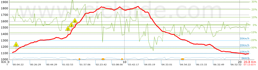


 list of points info

