325.Ruta de los Puentes, Molinos y Agua desde El Hoyo de Pinares

Hiking
Hiking
Ref..: 1084296
Published: 08/01/2023
Performed: 06/11/2022
Distance in Km: 18.66
Climb in m: 557
IBP: 66 HKG

Carlos Plaza Esteban
260 published routes

Add to my Group or Club

 Height in m      Climb in %      Speed in Km/h      Speed < 2 Km/h


Description of the route

DISTANCIA: 18,66 km.
TIEMPO: 8 h. 46 min. (5 h. 16 min. en movimiento).
VELOCIDAD MEDIA: 2,13 km/h.
DESNIVEL SUBIDO: 557 metros.
DESNIVEL BAJADO: 568,5 metros.
PORCENTAJE SUBIDA: 6,51 %/km.
PORCENTAJE BAJADA: 7,06 %/km.
DIFICULTAD: Fácil.
MATERIAL: Senderismo.
TERRENO: Pistas y senderos.
INDICE DE ESFUERZO: 66 HKG. MEDIA. (Condición Física Media).

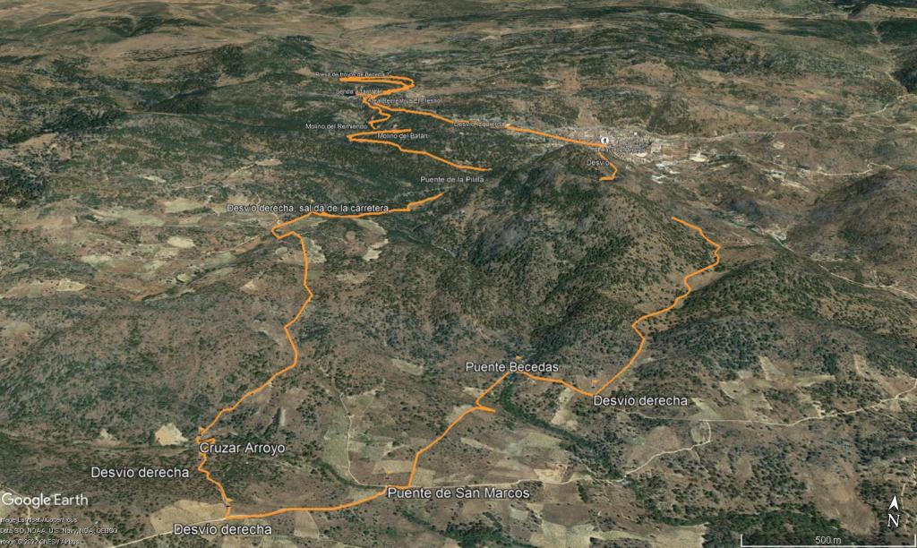
Salimos del pueblo cogiendo la calle Gran Capitán para luego seguir por la calle Rincón de la niña Montero donde sale un sendero a la izquierda que va en dirección a la Hoya de la Zorra. El camino está bien marcado y no ofrece perdida alguna. Ahora toca iniciar una suave bajada por un camino que va lindando con diferentes viñedos. Giramos a la derecha y enseguida nos encontramos con el primero de los puente que veremos hoy: El Puente Becedas.

Por la época del año que es, el río apenas lleva agua, no muy lejos, nos encontramos el Puente de San Marcos, de un estilo parecido al anterior y un menor tamaño. Seguimos el sendero hasta llegar a un cruce donde cogeremos un desvío a la derecha que comienza en subida, atravesamos un cauce seco sobre el arroyo de la pizarra (vadear en otra época del año) y comenzamos una suave subida que nos dejara en el cruce de la carretera AV-502 que seguiremos con precaución durante unos 600 metros, llegamos a el tercero de los puentes que visitaremos hoy, El puente de la Pililla. Cruzamos la carretera y comenzamos a subir para buscar la pista que nos llevará hasta el área recreativa del Batán que está perfectamente indicada, dispone de mesas y hay un par de fuentes (en está ocasión no tenían agua) y una gran mole de piedra en el centro con una pequeña inscripción. Justo al lado del área recreativa hay uno de los molinos que se incluyen en la ruta de los molinos, El Molino del Batán, siguiendo las marcas rojas en unos palos de madera y un poco más arriba hay otras ruinas, en este caso las del Molino del Remiendo.

Llegamos al área recreativa del Fresno, en una senda perfectamente definida y en ascensión desde el último molino, Ahora tomaremos la ruta del agua (marcada con palos e indicativo azul), hay una senda adaptada para los minusválidos pero por la mitad esta como cortada y está en estos momentos inaccesible por lo que vamos paralelos a ella por el sendero y pegados al primer Embalse del Hoyo de Becedas I, siguiendo esta preciosa senda entre bosque y pegados al Embalse, una ligera subida a la derecha nos hace llegar al siguiente Embalse del Hoyo de Becedas II.

Ahora toca volver hasta el pueblo y lo haremos por una pista que va a una altura superior a la que hemos cogido para llegar a los embalses.
Entraremos al pueblo por la zona de la Piscina (hay un bar donde tienen una cerveza fría estupenda) y llegaremos al lugar del que salimos esta mañana.

Nos vemos en las Montañas!!.


Presence of ramps


 Climbs  Distance  % of the total  Speed  Your speed would be  Time  Your time would be
   15 - 30%  0.375  2.01  1.86  ?  0:12:05  ?
   10 - 15%  1.392  7.46  3.27  ?  0:25:34  ?
   5 - 10%  2.772  14.86  3.3  ?  0:50:25  ?
   1 - 5%  4.018  21.54  3.75  ?  1:04:13  ?
   Total*  8.557 Km  45.86 %  3.37 Km/h  ? Km/h    2:32:17 h  ? h  
 Flat
   1 - -1%  2.05 Km  10.99 %  3.9 Km/h  ? Km/h    0:31:32 h  ? h  
 Descents
   -1 - -5%  2.696  14.45  3.38  ?  0:47:51  ?
   -5 - -10%  4.11  22.03  3.74  ?  1:05:57  ?
   -10 - -15%  0.787  4.22  3.96  ?  0:11:55  ?
   -15 - -30%  0.457  2.45  3.72  ?  0:07:23  ?
   Total*  8.05 Km  43.15 %  3.63 Km/h  ? Km/h    2:13:06 h  ? h  
* The total has not necessarily coincide with the sum of the partials after correction of errors

How long would it take you?

How long would it take you to cover this route?
There are routes without a valid time information, but with your average stats you can assess the possible duration

Carlos Plaza Esteban to cover this route you've need a time of:   5:16:55 h 
If you sign in and have a minimum of two tracks of this same modality, you can know your time for this route, calculated from your stats..


 Detected activity type =  ()
 Penalization due to track conditions: 0 %   ( > 50 % = MTB, < 50 % = RDB)
 Reliability of the track: B   (557/65/0/-/-/65)
 Correction level applied to the track: 0
DIFFICULTY OF THE ROUTE
IBP = 66 HKG
According to your statistics
 Your time in motion would be: ? h
Your average speed would be: ? Km/h
 

 Total Distance: 18.66 Km
 Analysed distance: 18.66 Km
 Linear distance: 0.01 Km

 Cumulated positive ramps: 557 m  list of points info
 Cumulated negative ramps: 568.57 m
 Maximum height: 1028.65 m
 Minimum height: 739.25 m
 Climbing Ratio: 6.51 %
 Descent ratio: 7.06 %
 Cumulated postive ramps per Km: 29.85 m
 Cumulated negative ramps per Km: 30.47 m

 Total time: 8:46:30 h
 Time in movement: 5:16:55 h
 According to your statistics
 Your time in motion would be: ? h  
 Stopped time: 3:29:35 h
 Maximum slope filter: ~55 %
 Minimum separation analysed: ~30 m
 Number of points: 225   (cad. 82.92 m)
 Significant waypoints: 204   (cad. 91.46 m / 90.67 %)

 Changes in direction per Km: 6.81
 Changes in direction > 5º por Km: 6.81
 Cumulated straight stretches: 0 Km
 Straight stretches per Km: 0 m
 Penalized slope changes: 6
 Penalized slope changes per Km: 0.322

 Average speed in total: 2.13 Km/h
 Average speed while moving: 3.53 Km/h
 According to your statistics
 Your average speed would be: ? Km/h  
 Maximum sustained speed: 5.31 Km/h


Comments

You can be the first one in commenting this route

 
My comments
:
Add comment  (Registered users)
 
Notify me answers to my comment  Do not notify answers to my comment


Share this route with a friend

Your friend will receive a message with a link to this page:
will see your email and your user name if you do it as registered user.


Write here your name (optional)

E-mail address of your friend(s). You can include various addresses separated by commas

Text or comment (optional) maximum 255 characters long, 255 Available characters

As a non registered users you need to fill-in the captcha text.
  Change image
Type the image characters.
 
 Share with a friend


Visited history

Delete history

Marked routes for review later or compare

My favorites


  Notify anomaly in this route Share in Facebook