DISTANCIA: 11,39 km.
TIEMPO: 6 h. 5 min. (4 h. 8 min. en movimiento).
VELOCIDAD MEDIA: 1,87 km/h.
DESNIVEL SUBIDO: 834 metros.
DESNIVEL BAJADO: 856,1 metros.
PORCENTAJE SUBIDA: 15,64 %/km.
PORCENTAJE BAJADA: 14,91 %/km.
DIFICULTAD: Moderado.
MATERIAL: Senderismo.
TERRENO: Pista, senderos, senderos con hitos, trepadas y destrepadas.
INDICE DE ESFUERZO: 91 HKG. DURA. (Condici�n F�sica Media).
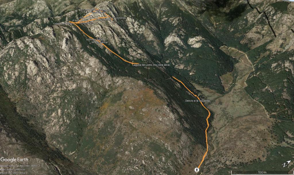
Salimos del parking de la Hoya de San Blas y continuamos por la pista o Senda de la Abutarda, ascendemos suavemente por ella durante 1,5 km, giramos por un sendero bien definido y ancho a mano izquierda y ascendemos por el durante unos 900 metros suavemente mediante zetas, cruzamos el Camino de San Blas y seguimos por el mismo sendero unos 200 metros hasta llegar a la Laguna del Lomo (hoy est� seca ya que este oto�o no ha llovido casi nada), volvemos al sendero y enfilamos la subida esta vez hay hitos llegando a un mirador Natural que nos ofrece unas grandes vistas a Soto, Manzanares y la Pedriza por detr�s, unos metros m�s adelante llegamos al Indio Navajo, una peculiar forma que seg�n subimos se ve claramente la cara, lo pasamos y seguimos ascendiendo por el marcado sendero intercalando algo de bosque con sendero pedregoso, tras 1 km llegamos al Collado de la Ventana, un ligero tentempi� y vamos en direcci�n al Collado de la U por el PR-M1 que ya no abandonaremos.
Ascendemos por el PR-M1 pasando por un divertido paso (agujero marcado con las marcas del PR) a la altura del Puro, subimos en direcci�n a la Esfinge y nos desviamos del PR-M1 a la derecha para ascender al Collado de los Hoyos, aqu� subimos a la derecha, dejando las mochilas y hacer por la derecha una peque�a trepada, pasamos al otro lado de la roca y bajamos d�nde unos hitos (alguien los ha colocado) nos se�alan la subida por una Grieta a la izquierda, ascendemos por ella buscando el mejor agarre, decir que hay que tener cierta habilidad para ello, tras subir la grieta nos encontramos con un vivac y un peque�o jard�n rocoso, trepamos f�cilmente por la izquierda para llegar a la cima del Cerro de los Hoyos (realmente no se si ser� porque en los mapas se se�ala un poco m�s abajo pegado al Cocodrilo y por encima del Puro), tras unas vistas espectaculares a 360 grados d�nde se divisa toda la Pedriza nos disponemos a bajar, destrepamos de nuevo al jard�n de roca y giramos a la izquierda destrepando con precauci�n para despu�s girar por un canal y trepar de nuevo a la izquierda para salir pr�cticamente d�nde tenemos las mochilas, las cogemos y vamos en busca de unas peque�as lagunillas en la roca que hemos visto desde la cima (esto es un extra, se puede obviar si se quiere), hacemos un poco el cabra con precauci�n con las trepadas y destrepadas por la roca.
Tras visitar las lagunillas cogemos el sendero marcado a la izquierda y vamos en direcci�n a la zona que llaman Herrada de Patas siguiendo el sendero con hitos llegamos a una zona con unos canales estrechos que hay que trepar con precauci�n y destrepar despu�s al llegar al otro lado (mejor en seco ya que con lluvia resbala bastante), llegamos a una campita y giramos a la derecha siguiendo los hitos, subimos un poco y llegamos a un paso estrecho (una chimenea que no tiene nada que envidiar a la del Yelmo), destrepamos la chimenea y a partir de aqu� ya el sendero es mucho m�s claro, lo seguimos con los hitos y llegamos de nuevo al Collado de la Ventana. A partir de aqu� ya nos toca volver por el camino de ida hasta los coches.
Nos vemos en las Monta�as!!. |

 Not from STRAVA
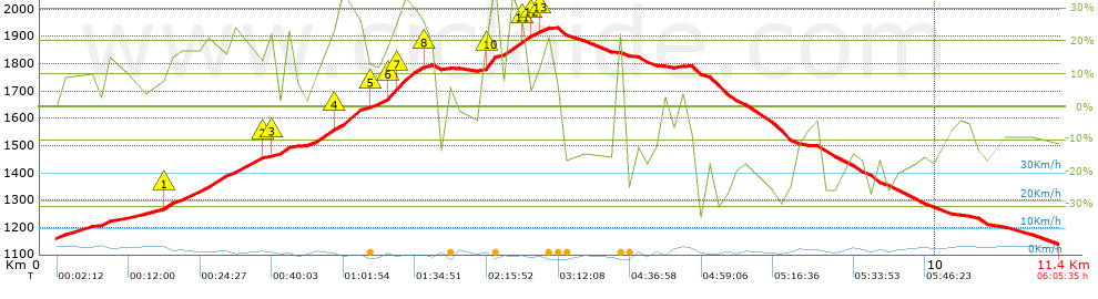


 list of points info

