Castell Montsoriu

MTB
MTB
Ref..: 1083561
Published: 03/01/2023
Performed: 02/01/2023
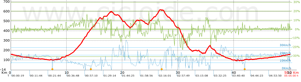
Distance in Km: 50.19
Climb in m: 1021
IBP: 73 BYC

Home_Bionic_B&G
429 published routes

Add to my Group or Club

 Height in m      Climb in %      Speed in Km/h      Speed < 2 Km/h

Climbs > 5%

Climbs >5% Climbs >10% Climbs >15% Climbs >20% Climbs >25%
 Steep slope of 202 m.   Average slope  Distances  Download as waypoint
1
 Km 8.921  6%  202 m
 Steep slope of 144 m.  Average slope  Distances  Download as waypoint
2
 Km 9.811  8%  144 m
 Steep slope of 100 m.  Average slope  Distances  Download as waypoint
3
 Km 10.985  5%  100 m
 Steep slope of 241 m.  Average slope  Distances  Download as waypoint
4
 Km 11.188  6%  241 m
 Steep slope of 686 m.  Average slope  Distances  Download as waypoint
5
 Km 11.57  7%  686 m
 Steep slope of 966 m.  Average slope  Distances  Download as waypoint
6
 Km 12.393  8%  376 m
7
 Km 12.769  11%  202 m
8
 Km 12.971  8%  388 m
 Steep slope of 600 m.  Average slope  Distances  Download as waypoint
9
 Km 13.495  7%  63 m
10
 Km 13.558  14%  163 m
11
 Km 13.721  8%  374 m
 Steep slope of 307 m.  Average slope  Distances  Download as waypoint
12
 Km 14.224  8%  307 m
 Steep slope of 181 m.  Average slope  Distances  Download as waypoint
13
 Km 14.761  6%  181 m
 Steep slope of 814 m.  Average slope  Distances  Download as waypoint
14
 Km 15.051  10%  34 m
15
 Km 15.085  9%  135 m
16
 Km 15.22  8%  128 m
17
 Km 15.348  11%  128 m
18
 Km 15.476  8%  389 m
 Steep slope of 231 m.  Average slope  Distances  Download as waypoint
19
 Km 16.453  7%  34 m
20
 Km 16.487  11%  133 m
21
 Km 16.62  11%  64 m
 Steep slope of 329 m.  Average slope  Distances  Download as waypoint
22
 Km 17.267  8%  329 m
 Steep slope of 101 m.  Average slope  Distances  Download as waypoint
23
 Km 17.749  10%  101 m
 Steep slope of 310 m.  Average slope  Distances  Download as waypoint
24
 Km 21.414  6%  310 m
 Steep slope of 428 m.  Average slope  Distances  Download as waypoint
25
 Km 21.863  9%  428 m
 Steep slope of 170 m.  Average slope  Distances  Download as waypoint
26
 Km 22.387  8%  170 m
 Steep slope of 361 m.  Average slope  Distances  Download as waypoint
27
 Km 24.653  11%  30 m
28
 Km 24.682  14%  99 m
29
 Km 24.781  11%  232 m
 Steep slope of 548 m.  Average slope  Distances  Download as waypoint
30
 Km 25.168  7%  548 m
 Steep slope of 709 m.  Average slope  Distances  Download as waypoint
31
 Km 25.933  8%  409 m
32
 Km 26.342  11%  133 m
33
 Km 26.474  11%  167 m
 Steep slope of 869 m.  Average slope  Distances  Download as waypoint
34
 Km 34.854  8%  30 m
35
 Km 34.884  12%  138 m
36
 Km 35.023  10%  101 m
37
 Km 35.124  11%  135 m
38
 Km 35.259  7%  100 m
39
 Km 35.359  11%  97 m
40
 Km 35.455  6%  125 m
41
 Km 35.58  6%  143 m


Description of the route


Presence of ramps


 Climbs  Distance  % of the total  Speed  Your speed would be  Time  Your time would be
   15 - 30%  0.199  0.4  5.34  ?  0:02:14  ?
   10 - 15%  1.893  3.77  7.24  ?  0:15:41  ?
   5 - 10%  7.062  14.07  9.42  ?  0:44:59  ?
   1 - 5%  9.593  19.11  14.23  ?  0:40:27  ?
   Total*  18.746 Km  37.35 %  10.88 Km/h  ? Km/h    1:43:21 h  ? h  
 Flat
   1 - -1%  12.144 Km  24.2 %  18.28 Km/h  ? Km/h    0:39:51 h  ? h  
 Descents
   -1 - -5%  11.207  22.33  18.32  ?  0:36:42  ?
   -5 - -10%  5.672  11.3  16.71  ?  0:20:22  ?
   -10 - -15%  1.732  3.45  16.19  ?  0:06:25  ?
   -15 - -30%  0.69  1.37  15.92  ?  0:02:36  ?
   Total*  19.301 Km  38.45 %  17.52 Km/h  ? Km/h    1:06:05 h  ? h  
* The total has not necessarily coincide with the sum of the partials after correction of errors

How long would it take you?

How long would it take you to cover this route?
There are routes without a valid time information, but with your average stats you can assess the possible duration

Home_Bionic_B&G to cover this route you've need a time of:   3:29:17 h 
If you sign in and have a minimum of two tracks of this same modality, you can know your time for this route, calculated from your stats..


¿Cuanto consumirá tu E-BIKE?

Entra tu E-IBP (formato n,nn)

E-IBP :   X 73 = 


 Detected activity type =  ()
 Penalization due to track conditions: 66 %   ( > 50 % = MTB, < 50 % = RDB)
 Reliability of the track: B   (1021/69/0/-/-/69)
 Correction level applied to the track: 0
DIFFICULTY OF THE ROUTE
IBP = 73 BYC
According to your statistics
 Your time in motion would be: ? h
Your average speed would be: ? Km/h
 

 Total Distance: 50.19 Km
 Analysed distance: 50.19 Km
 Linear distance: 0.21 Km

 Cumulated positive ramps: 1020.6 m  list of points info
 Cumulated negative ramps: 1017.4 m
 Maximum height: 618.6 m
 Minimum height: 93.6 m
 Climbing Ratio: 5.44 %
 Descent ratio: 5.27 %
 Cumulated postive ramps per Km: 20.33 m
 Cumulated negative ramps per Km: 20.27 m

 Total time: 5:05:00 h
 Time in movement: 3:29:17 h
 According to your statistics
 Your time in motion would be: ? h  
 Stopped time: 1:35:43 h
 Maximum slope filter: ~30 %
 Minimum separation analysed: ~30 m
 Number of points: 3352   (cad. 14.97 m)
 Significant waypoints: 1328   (cad. 37.79 m / 39.62 %)

 Changes in direction per Km: 11.42
 Changes in direction > 5º por Km: 7.95
 Cumulated straight stretches: 9.75 Km
 Straight stretches per Km: 194.26 m
 Penalized slope changes: 11
 Penalized slope changes per Km: 0.219

 Average speed in total: 9.87 Km/h
 Average speed while moving: 14.39 Km/h
 According to your statistics
 Your average speed would be: ? Km/h  
 Maximum sustained speed: 46.39 Km/h


Comments

You can be the first one in commenting this route

 
My comments
:
Add comment  (Registered users)
 
Notify me answers to my comment  Do not notify answers to my comment


Share this route with a friend

Your friend will receive a message with a link to this page:
will see your email and your user name if you do it as registered user.


Write here your name (optional)

E-mail address of your friend(s). You can include various addresses separated by commas

Text or comment (optional) maximum 255 characters long, 255 Available characters

As a non registered users you need to fill-in the captcha text.
  Change image
Type the image characters.
 
 Share with a friend


Visited history

Delete history

Marked routes for review later or compare

My favorites


  Notify anomaly in this route Share in Facebook