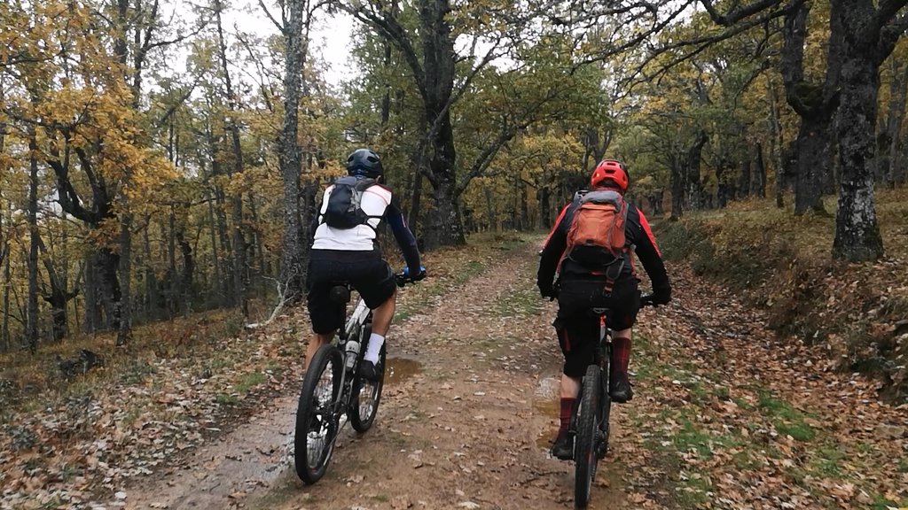
Montejo.....

MTB
MTB
Ref..: 1078434
Published: 14/11/2022
Performed: 13/11/2022
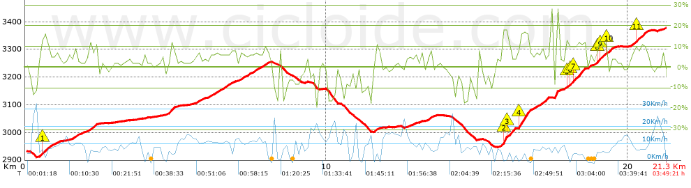
Distance in Km: 21.26
Climb in m: 899
IBP: 85 BYC

Brujo1971
Author: Brujo1971
417 published routes

Add to my Group or Club

 Height in m      Climb in %      Speed in Km/h      Speed < 2 Km/h

Climbs > 5%

Climbs >5% Climbs >10% Climbs >15% Climbs >20% Climbs >25%
 Steep slope of 520 m.   Average slope  Distances  Download as waypoint
1
 Km 0.463  6%  72 m
2
 Km 0.535  13%  177 m
3
 Km 0.712  7%  271 m
 Steep slope of 184 m.  Average slope  Distances  Download as waypoint
4
 Km 1.621  8%  184 m
 Steep slope of 334 m.  Average slope  Distances  Download as waypoint
5
 Km 2.088  9%  334 m
 Steep slope of 111 m.  Average slope  Distances  Download as waypoint
6
 Km 4.516  5%  111 m
 Steep slope of 213 m.  Average slope  Distances  Download as waypoint
7
 Km 4.757  11%  213 m
 Steep slope of 201 m.  Average slope  Distances  Download as waypoint
8
 Km 5.594  6%  201 m
 Steep slope of 686 m.  Average slope  Distances  Download as waypoint
9
 Km 6.097  7%  686 m
 Steep slope of 982 m.  Average slope  Distances  Download as waypoint
10
 Km 7.09  7%  982 m
 Steep slope of 112 m.  Average slope  Distances  Download as waypoint
11
 Km 11.576  9%  112 m
 Steep slope of 186 m.  Average slope  Distances  Download as waypoint
12
 Km 13.283  6%  186 m
 Steep slope of 392 m.  Average slope  Distances  Download as waypoint
13
 Km 15.804  7%  38 m
14
 Km 15.843  22%  137 m
15
 Km 15.98  11%  186 m
16
 Km 16.166  23%  31 m
 Steep slope of 679 m.  Average slope  Distances  Download as waypoint
17
 Km 16.327  8%  33 m
18
 Km 16.36  17%  333 m
19
 Km 16.693  8%  313 m
 Steep slope of 156 m.  Average slope  Distances  Download as waypoint
20
 Km 17.125  7%  156 m
 Steep slope of 291 m.  Average slope  Distances  Download as waypoint
21
 Km 17.424  6%  182 m
22
 Km 17.607  22%  109 m
 Steep slope of 661 m.  Average slope  Distances  Download as waypoint
23
 Km 17.948  11%  146 m
24
 Km 18.094  10%  112 m
25
 Km 18.206  13%  293 m
26
 Km 18.499  6%  110 m
 Steep slope of 560 m.  Average slope  Distances  Download as waypoint
27
 Km 18.707  7%  254 m
28
 Km 18.961  11%  142 m
29
 Km 19.103  10%  120 m
30
 Km 19.223  12%  44 m
 Steep slope of 137 m.  Average slope  Distances  Download as waypoint
31
 Km 19.369  10%  137 m
 Steep slope of 614 m.  Average slope  Distances  Download as waypoint
32
 Km 20.054  8%  209 m
33
 Km 20.263  11%  233 m
34
 Km 20.497  8%  172 m


Description of the route


Presence of ramps


 Climbs  Distance  % of the total  Speed  Your speed would be  Time  Your time would be
   15 - 30%  0.977  4.6  3.86  ?  0:15:12  ?
   10 - 15%  1.371  6.45  6.4  ?  0:12:51  ?
   5 - 10%  5.414  25.46  8.69  ?  0:37:22  ?
   1 - 5%  5.627  26.47  10.24  ?  0:32:59  ?
   Total*  13.39 Km  62.98 %  8.16 Km/h  ? Km/h    1:38:24 h  ? h  
 Flat
   1 - -1%  2.309 Km  10.86 %  11.92 Km/h  ? Km/h    0:11:37 h  ? h  
 Descents
   -1 - -5%  2.008  9.45  9.45  ?  0:12:45  ?
   -5 - -10%  1.669  7.85  9.68  ?  0:10:21  ?
   -10 - -15%  1.186  5.58  11.86  ?  0:06:00  ?
   -15 - -30%  0.722  3.4  8.81  ?  0:04:55  ?
   Total*  5.586 Km  26.27 %  9.85 Km/h  ? Km/h    0:34:01 h  ? h  
* The total has not necessarily coincide with the sum of the partials after correction of errors

How long would it take you?

How long would it take you to cover this route?
There are routes without a valid time information, but with your average stats you can assess the possible duration

Brujo1971 to cover this route you've need a time of:   2:24:02 h 
If you sign in and have a minimum of two tracks of this same modality, you can know your time for this route, calculated from your stats..


¿Cuanto consumirá tu E-BIKE?

Entra tu E-IBP (formato n,nn)

E-IBP :   X 85 = 


 Detected activity type =  ()
 Penalization due to track conditions: 77 %   ( > 50 % = MTB, < 50 % = RDB)
 Reliability of the track: B   (914/70/0/-/-/70)
 Correction level applied to the track: 0
DIFFICULTY OF THE ROUTE
IBP = 85 BYC
According to your statistics
 Your time in motion would be: ? h
Your average speed would be: ? Km/h
 

 Total Distance: 21.26 Km
 Analysed distance: 21.26 Km
 Linear distance: 7.56 Km

 Cumulated positive ramps: 898.83 m  list of points info
 Cumulated negative ramps: 456.35 m
 Maximum height: 3377.6 m
 Minimum height: 2910.8 m
 Climbing Ratio: 6.71 %
 Descent ratio: 8.17 %
 Cumulated postive ramps per Km: 42.28 m
 Cumulated negative ramps per Km: 21.47 m

 Total time: 3:49:21 h
 Time in movement: 2:24:02 h
 According to your statistics
 Your time in motion would be: ? h  
 Stopped time: 1:25:19 h
 Maximum slope filter: ~30 %
 Minimum separation analysed: ~30 m
 Number of points: 1476   (cad. 14.41 m)
 Significant waypoints: 572   (cad. 37.24 m / 38.75 %)

 Changes in direction per Km: 10.87
 Changes in direction > 5º por Km: 8.51
 Cumulated straight stretches: 2.94 Km
 Straight stretches per Km: 138.29 m
 Penalized slope changes: 5
 Penalized slope changes per Km: 0.235

 Average speed in total: 5.56 Km/h
 Average speed while moving: 8.86 Km/h
 According to your statistics
 Your average speed would be: ? Km/h  
 Maximum sustained speed: 34.65 Km/h


Comments

You can be the first one in commenting this route

 
My comments
:
Add comment  (Registered users)
 
Notify me answers to my comment  Do not notify answers to my comment


Share this route with a friend

Your friend will receive a message with a link to this page:
will see your email and your user name if you do it as registered user.


Write here your name (optional)

E-mail address of your friend(s). You can include various addresses separated by commas

Text or comment (optional) maximum 255 characters long, 255 Available characters

As a non registered users you need to fill-in the captcha text.
  Change image
Type the image characters.
 
 Share with a friend


Visited history

Delete history

Marked routes for review later or compare

My favorites


  Notify anomaly in this route Share in Facebook