Aquí estamos de nuevo __

MTB
MTB
Ref..: 1078254
Published: 13/11/2022
Performed: 13/11/2022
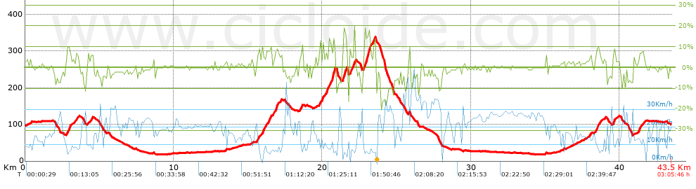
Distance in Km: 43.5
Climb in m: 717
IBP: 56 BYC

Near ...
Cornella De Llobregat, Esplugues De Llobregat, Sant Joan Despi, Sant Just Desvern
Xiscu_Muñoz
Author: Xiscu_Muñoz
207 published routes

Add to my Group or Club

 Height in m      Climb in %      Speed in Km/h      Speed < 2 Km/h

Climbs > 5%

Climbs >5% Climbs >10% Climbs >15% Climbs >20% Climbs >25%
 Steep slope of 309 m.   Average slope  Distances  Download as waypoint
1
 Km 2.782  8%  309 m
 Steep slope of 122 m.  Average slope  Distances  Download as waypoint
2
 Km 3.45  7%  122 m
 Steep slope of 164 m.  Average slope  Distances  Download as waypoint
3
 Km 4.408  7%  164 m
 Steep slope of 174 m.  Average slope  Distances  Download as waypoint
4
 Km 15.64  8%  174 m
 Steep slope of 597 m.  Average slope  Distances  Download as waypoint
5
 Km 15.936  13%  103 m
6
 Km 16.038  7%  494 m
 Steep slope of 328 m.  Average slope  Distances  Download as waypoint
7
 Km 16.657  8%  328 m
 Steep slope of 218 m.  Average slope  Distances  Download as waypoint
8
 Km 18.459  7%  218 m
 Steep slope of 289 m.  Average slope  Distances  Download as waypoint
9
 Km 19.759  7%  289 m
 Steep slope of 624 m.  Average slope  Distances  Download as waypoint
10
 Km 20.225  9%  466 m
11
 Km 20.691  16%  158 m
 Steep slope of 302 m.  Average slope  Distances  Download as waypoint
12
 Km 21.366  8%  69 m
13
 Km 21.435  15%  178 m
14
 Km 21.613  7%  55 m
 Steep slope of 368 m.  Average slope  Distances  Download as waypoint
15
 Km 21.815  9%  189 m
16
 Km 22.004  12%  179 m
 Steep slope of 526 m.  Average slope  Distances  Download as waypoint
17
 Km 22.795  15%  234 m
18
 Km 23.029  13%  104 m
19
 Km 23.132  18%  71 m
20
 Km 23.204  7%  117 m
 Steep slope of 114 m.  Average slope  Distances  Download as waypoint
21
 Km 23.44  14%  114 m
 Steep slope of 120 m.  Average slope  Distances  Download as waypoint
22
 Km 37.955  6%  120 m
 Steep slope of 386 m.  Average slope  Distances  Download as waypoint
23
 Km 38.352  8%  386 m
 Steep slope of 185 m.  Average slope  Distances  Download as waypoint
24
 Km 39.532  9%  185 m
 Steep slope of 377 m.  Average slope  Distances  Download as waypoint
25
 Km 41.256  7%  377 m


Description of the route


Presence of ramps


 Climbs  Distance  % of the total  Speed  Your speed would be  Time  Your time would be
   15 - 30%  0.514  1.18  4.3  ?  0:07:10  ?
   10 - 15%  1.378  3.17  6.97  ?  0:11:52  ?
   5 - 10%  3.709  8.53  8.58  ?  0:25:56  ?
   1 - 5%  7.809  17.95  12.21  ?  0:38:22  ?
   Total*  13.41 Km  30.82 %  9.66 Km/h  ? Km/h    1:23:20 h  ? h  
 Flat
   1 - -1%  16.561 Km  38.07 %  20.34 Km/h  ? Km/h    0:48:51 h  ? h  
 Descents
   -1 - -5%  8.248  18.96  20.63  ?  0:23:59  ?
   -5 - -10%  3.466  7.97  22.36  ?  0:09:18  ?
   -10 - -15%  1.345  3.09  22.83  ?  0:03:32  ?
   -15 - -30%  0.475  1.09  15.99  ?  0:01:47  ?
   Total*  13.534 Km  31.11 %  21.04 Km/h  ? Km/h    0:38:36 h  ? h  
* The total has not necessarily coincide with the sum of the partials after correction of errors

How long would it take you?

How long would it take you to cover this route?
There are routes without a valid time information, but with your average stats you can assess the possible duration

Xiscu_Muñoz to cover this route you've need a time of:   2:50:47 h 
If you sign in and have a minimum of two tracks of this same modality, you can know your time for this route, calculated from your stats..


¿Cuanto consumirá tu E-BIKE?

Entra tu E-IBP (formato n,nn)

E-IBP :   X 56 = 


 Detected activity type =  ()
 Penalization due to track conditions: 54 %   ( > 50 % = MTB, < 50 % = RDB)
 Reliability of the track: B   (717/64/0/-/-/64)
 Correction level applied to the track: 0
DIFFICULTY OF THE ROUTE
IBP = 56 BYC
According to your statistics
 Your time in motion would be: ? h
Your average speed would be: ? Km/h
 

 Total Distance: 43.5 Km
 Analysed distance: 43.5 Km
 Linear distance: 0.18 Km

 Cumulated positive ramps: 717.3 m  list of points info
 Cumulated negative ramps: 711.3 m
 Maximum height: 338.2 m
 Minimum height: 17.4 m
 Climbing Ratio: 5.35 %
 Descent ratio: 5.26 %
 Cumulated postive ramps per Km: 16.49 m
 Cumulated negative ramps per Km: 16.35 m

 Total time: 3:05:46 h
 Time in movement: 2:50:47 h
 According to your statistics
 Your time in motion would be: ? h  
 Stopped time: 0:14:59 h
 Maximum slope filter: ~30 %
 Minimum separation analysed: ~30 m
 Number of points: 2003   (cad. 21.72 m)
 Significant waypoints: 1040   (cad. 41.83 m / 51.92 %)

 Changes in direction per Km: 8.92
 Changes in direction > 5º por Km: 5.82
 Cumulated straight stretches: 13.486 Km
 Straight stretches per Km: 310.02 m
 Penalized slope changes: 9
 Penalized slope changes per Km: 0.207

 Average speed in total: 14.05 Km/h
 Average speed while moving: 15.28 Km/h
 According to your statistics
 Your average speed would be: ? Km/h  
 Maximum sustained speed: 54.85 Km/h


Comments

You can be the first one in commenting this route

 
My comments
:
Add comment  (Registered users)
 
Notify me answers to my comment  Do not notify answers to my comment


Share this route with a friend

Your friend will receive a message with a link to this page:
will see your email and your user name if you do it as registered user.


Write here your name (optional)

E-mail address of your friend(s). You can include various addresses separated by commas

Text or comment (optional) maximum 255 characters long, 255 Available characters

As a non registered users you need to fill-in the captcha text.
  Change image
Type the image characters.
 
 Share with a friend


Visited history

Delete history

Marked routes for review later or compare

My favorites


  Notify anomaly in this route Share in Facebook