Piélago 14 y algo más..._

Road
Road
Ref..: 1070581
Published: 19/09/2022
Performed: 18/09/2022
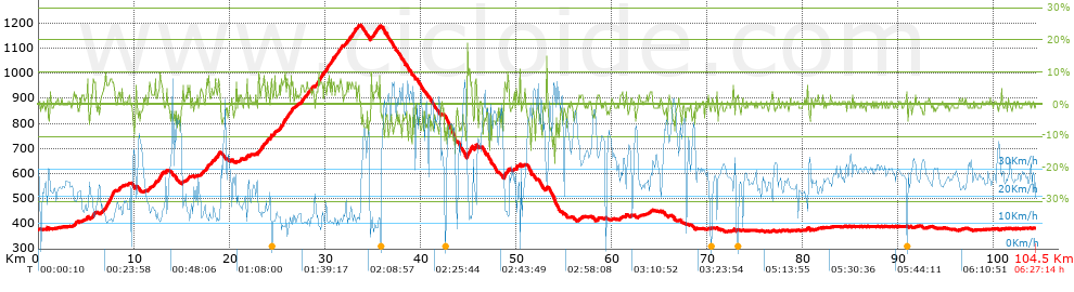
Distance in Km: 104.46
Climb in m: 1367
IBP: 98 BYC


 Height in m      Climb in %      Speed in Km/h      Speed < 2 Km/h

Climbs > 5%

Climbs >5% Climbs >10% Climbs >15% Climbs >20% Climbs >25%
 Steep slope of 178 m.   Average slope  Distances  Download as waypoint
1
 Km 5.742  7%  178 m
 Steep slope of 1029 m.  Average slope  Distances  Download as waypoint
2
 Km 6.948  7%  1029 m
 Steep slope of 194 m.  Average slope  Distances  Download as waypoint
3
 Km 12.085  5%  194 m
 Steep slope of 472 m.  Average slope  Distances  Download as waypoint
4
 Km 12.564  7%  472 m
 Steep slope of 189 m.  Average slope  Distances  Download as waypoint
5
 Km 15.619  5%  189 m
 Steep slope of 133 m.  Average slope  Distances  Download as waypoint
6
 Km 17.082  6%  133 m
 Steep slope of 170 m.  Average slope  Distances  Download as waypoint
7
 Km 17.577  7%  170 m
 Steep slope of 100 m.  Average slope  Distances  Download as waypoint
8
 Km 18.131  5%  100 m
 Steep slope of 110 m.  Average slope  Distances  Download as waypoint
9
 Km 18.478  7%  110 m
 Steep slope of 178 m.  Average slope  Distances  Download as waypoint
10
 Km 18.803  7%  178 m
 Steep slope of 144 m.  Average slope  Distances  Download as waypoint
11
 Km 21.75  7%  144 m
 Steep slope of 118 m.  Average slope  Distances  Download as waypoint
12
 Km 23.034  8%  118 m
 Steep slope of 260 m.  Average slope  Distances  Download as waypoint
13
 Km 23.379  6%  260 m
 Steep slope of 160 m.  Average slope  Distances  Download as waypoint
14
 Km 23.903  7%  160 m
 Steep slope of 185 m.  Average slope  Distances  Download as waypoint
15
 Km 24.286  7%  185 m
 Steep slope of 451 m.  Average slope  Distances  Download as waypoint
16
 Km 25.413  7%  451 m
 Steep slope of 271 m.  Average slope  Distances  Download as waypoint
17
 Km 25.968  6%  271 m
 Steep slope of 247 m.  Average slope  Distances  Download as waypoint
18
 Km 26.416  7%  247 m
 Steep slope of 203 m.  Average slope  Distances  Download as waypoint
19
 Km 27.528  6%  203 m
 Steep slope of 142 m.  Average slope  Distances  Download as waypoint
20
 Km 28.01  6%  142 m
 Steep slope of 103 m.  Average slope  Distances  Download as waypoint
21
 Km 28.255  5%  103 m
 Steep slope of 142 m.  Average slope  Distances  Download as waypoint
22
 Km 28.675  5%  142 m
 Steep slope of 483 m.  Average slope  Distances  Download as waypoint
23
 Km 29.281  7%  483 m
 Steep slope of 177 m.  Average slope  Distances  Download as waypoint
24
 Km 29.876  6%  177 m
 Steep slope of 320 m.  Average slope  Distances  Download as waypoint
25
 Km 30.165  7%  320 m
 Steep slope of 327 m.  Average slope  Distances  Download as waypoint
26
 Km 30.619  6%  327 m
 Steep slope of 213 m.  Average slope  Distances  Download as waypoint
27
 Km 31.22  6%  213 m
 Steep slope of 163 m.  Average slope  Distances  Download as waypoint
28
 Km 31.542  6%  163 m
 Steep slope of 104 m.  Average slope  Distances  Download as waypoint
29
 Km 32.279  6%  104 m
 Steep slope of 103 m.  Average slope  Distances  Download as waypoint
30
 Km 32.523  7%  103 m
 Steep slope of 384 m.  Average slope  Distances  Download as waypoint
31
 Km 32.816  6%  384 m
 Steep slope of 204 m.  Average slope  Distances  Download as waypoint
32
 Km 34.949  6%  204 m
 Steep slope of 200 m.  Average slope  Distances  Download as waypoint
33
 Km 35.294  6%  200 m
 Steep slope of 105 m.  Average slope  Distances  Download as waypoint
34
 Km 35.691  7%  105 m
 Steep slope of 410 m.  Average slope  Distances  Download as waypoint
35
 Km 44.94  9%  410 m
 Steep slope of 147 m.  Average slope  Distances  Download as waypoint
36
 Km 45.703  7%  147 m
 Steep slope of 192 m.  Average slope  Distances  Download as waypoint
37
 Km 48.773  9%  192 m
 Steep slope of 137 m.  Average slope  Distances  Download as waypoint
38
 Km 49.123  9%  137 m
 Steep slope of 108 m.  Average slope  Distances  Download as waypoint
39
 Km 50.032  11%  108 m


Description of the route


Presence of ramps


 Climbs  Distance  % of the total  Speed  Your speed would be  Time  Your time would be
   15 - 30%  0.154  0.15  22.22  ?  0:00:25  ?
   10 - 15%  0.525  0.5  7.74  ?  0:04:04  ?
   5 - 10%  10.357  9.92  12.87  ?  0:48:16  ?
   1 - 5%  22.782  21.81  18.87  ?  1:12:27  ?
   Total*  33.818 Km  32.37 %  16.21 Km/h  ? Km/h    2:05:12 h  ? h  
 Flat
   1 - -1%  40.012 Km  38.3 %  27.19 Km/h  ? Km/h    1:28:17 h  ? h  
 Descents
   -1 - -5%  19.49  18.66  35.17  ?  0:33:15  ?
   -5 - -10%  8.999  8.61  46.55  ?  0:11:36  ?
   -10 - -15%  1.919  1.84  45.44  ?  0:02:32  ?
   -15 - -30%  0.222  0.21  44.31  ?  0:00:18  ?
   Total*  30.629 Km  29.32 %  38.54 Km/h  ? Km/h    0:47:41 h  ? h  
* The total has not necessarily coincide with the sum of the partials after correction of errors

How long would it take you?

How long would it take you to cover this route?
There are routes without a valid time information, but with your average stats you can assess the possible duration

Alfonso Puñal to cover this route you've need a time of:   4:21:10 h 
If you sign in and have a minimum of two tracks of this same modality, you can know your time for this route, calculated from your stats..


¿Cuanto consumirá tu E-BIKE?

Entra tu E-IBP (formato n,nn)

E-IBP :   X 98 = 


 Detected activity type =  ()
 Penalization due to track conditions: 35 %   ( > 50 % = MTB, < 50 % = RDB)
 Reliability of the track: B   (1366/59/0/-/-/59)
 Correction level applied to the track: 0
DIFFICULTY OF THE ROUTE
IBP = 98 BYC
According to your statistics
 Your time in motion would be: ? h
Your average speed would be: ? Km/h
 

 Total Distance: 104.46 Km
 Analysed distance: 104.46 Km
 Linear distance: 0.05 Km

 Cumulated positive ramps: 1366.8 m  list of points info
 Cumulated negative ramps: 1368.4 m
 Maximum height: 1191 m
 Minimum height: 368.2 m
 Climbing Ratio: 4.04 %
 Descent ratio: 4.47 %
 Cumulated postive ramps per Km: 13.08 m
 Cumulated negative ramps per Km: 13.1 m

 Total time: 6:27:14 h
 Time in movement: 4:21:10 h
 According to your statistics
 Your time in motion would be: ? h  
 Stopped time: 2:06:04 h
 Maximum slope filter: ~30 %
 Minimum separation analysed: ~30 m
 Number of points: 7546   (cad. 13.84 m)
 Significant waypoints: 2970   (cad. 35.17 m / 39.36 %)

 Changes in direction per Km: 9.3
 Changes in direction > 5º por Km: 3.67
 Cumulated straight stretches: 51.396 Km
 Straight stretches per Km: 492.02 m
 Penalized slope changes: 11
 Penalized slope changes per Km: 0.105

 Average speed in total: 16.19 Km/h
 Average speed while moving: 24 Km/h
 According to your statistics
 Your average speed would be: ? Km/h  
 Maximum sustained speed: 64.99 Km/h


Comments

You can be the first one in commenting this route

 
My comments
:
Add comment  (Registered users)
 
Notify me answers to my comment  Do not notify answers to my comment


Share this route with a friend

Your friend will receive a message with a link to this page:
will see your email and your user name if you do it as registered user.


Write here your name (optional)

E-mail address of your friend(s). You can include various addresses separated by commas

Text or comment (optional) maximum 255 characters long, 255 Available characters

As a non registered users you need to fill-in the captcha text.
  Change image
Type the image characters.
 
 Share with a friend


Visited history

Delete history

Marked routes for review later or compare

My favorites


  Notify anomaly in this route Share in Facebook