Salida con la Flaca

Road
Road
Ref..: 1069061
Published: 10/09/2022
Performed: 10/09/2022
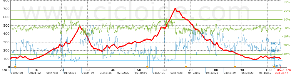
Distance in Km: 105.23
Climb in m: 1320
IBP: 92 BYC

Andres A.M.
Author: Andres A.M.
123 published routes

Add to my Group or Club

 Height in m      Climb in %      Speed in Km/h      Speed < 2 Km/h

Climbs > 5%

Climbs >5% Climbs >10% Climbs >15% Climbs >20% Climbs >25%
 Steep slope of 139 m.   Average slope  Distances  Download as waypoint
1
 Km 16.548  5%  139 m
 Steep slope of 475 m.  Average slope  Distances  Download as waypoint
2
 Km 18.578  6%  475 m
 Steep slope of 308 m.  Average slope  Distances  Download as waypoint
3
 Km 20.983  8%  308 m
 Steep slope of 430 m.  Average slope  Distances  Download as waypoint
4
 Km 23.222  7%  430 m
 Steep slope of 398 m.  Average slope  Distances  Download as waypoint
5
 Km 23.928  6%  398 m
 Steep slope of 352 m.  Average slope  Distances  Download as waypoint
6
 Km 24.651  6%  352 m
 Steep slope of 400 m.  Average slope  Distances  Download as waypoint
7
 Km 25.324  5%  400 m
 Steep slope of 862 m.  Average slope  Distances  Download as waypoint
8
 Km 25.91  7%  862 m
 Steep slope of 174 m.  Average slope  Distances  Download as waypoint
9
 Km 35.931  6%  174 m
 Steep slope of 343 m.  Average slope  Distances  Download as waypoint
10
 Km 37.168  6%  343 m
 Steep slope of 183 m.  Average slope  Distances  Download as waypoint
11
 Km 38.644  8%  183 m
 Steep slope of 145 m.  Average slope  Distances  Download as waypoint
12
 Km 55.336  5%  145 m
 Steep slope of 253 m.  Average slope  Distances  Download as waypoint
13
 Km 55.618  7%  253 m
 Steep slope of 437 m.  Average slope  Distances  Download as waypoint
14
 Km 57.236  6%  437 m
 Steep slope of 784 m.  Average slope  Distances  Download as waypoint
15
 Km 57.791  7%  784 m
 Steep slope of 529 m.  Average slope  Distances  Download as waypoint
16
 Km 60.204  7%  529 m
 Steep slope of 495 m.  Average slope  Distances  Download as waypoint
17
 Km 60.849  6%  495 m
 Steep slope of 447 m.  Average slope  Distances  Download as waypoint
18
 Km 61.5  6%  447 m
 Steep slope of 308 m.  Average slope  Distances  Download as waypoint
19
 Km 62.062  7%  308 m
 Steep slope of 297 m.  Average slope  Distances  Download as waypoint
20
 Km 62.485  7%  297 m
 Steep slope of 1040 m.  Average slope  Distances  Download as waypoint
21
 Km 62.924  6%  1040 m
 Steep slope of 130 m.  Average slope  Distances  Download as waypoint
22
 Km 72.287  6%  130 m
 Steep slope of 208 m.  Average slope  Distances  Download as waypoint
23
 Km 79.724  5%  208 m


Description of the route


Presence of ramps


 Climbs  Distance  % of the total  Speed  Your speed would be  Time  Your time would be
   15 - 30%  0  0  0  ?  0:00:00  ?
   10 - 15%  0.263  0.25  10.75  ?  0:01:28  ?
   5 - 10%  9.166  8.71  12.69  ?  0:43:20  ?
   1 - 5%  28.993  27.55  20.47  ?  1:25:00  ?
   Total*  38.422 Km  36.51 %  17.76 Km/h  ? Km/h    2:09:48 h  ? h  
 Flat
   1 - -1%  28.444 Km  27.03 %  25.94 Km/h  ? Km/h    1:05:47 h  ? h  
 Descents
   -1 - -5%  28.367  26.96  33.16  ?  0:51:20  ?
   -5 - -10%  9.994  9.5  43.66  ?  0:13:44  ?
   -10 - -15%  0  0  0  ?  0:00:00  ?
   -15 - -30%  0  0  0  ?  0:00:00  ?
   Total*  38.361 Km  36.46 %  35.37 Km/h  ? Km/h    1:05:04 h  ? h  
* The total has not necessarily coincide with the sum of the partials after correction of errors

How long would it take you?

How long would it take you to cover this route?
There are routes without a valid time information, but with your average stats you can assess the possible duration

Andres A.M. to cover this route you've need a time of:   4:20:39 h 
If you sign in and have a minimum of two tracks of this same modality, you can know your time for this route, calculated from your stats..


¿Cuanto consumirá tu E-BIKE?

Entra tu E-IBP (formato n,nn)

E-IBP :   X 92 = 


 Detected activity type =  ()
 Penalization due to track conditions: 35 %   ( > 50 % = MTB, < 50 % = RDB)
 Reliability of the track: A   (1319/79/0/-/-/79)
 Correction level applied to the track: 0
DIFFICULTY OF THE ROUTE
IBP = 92 BYC
According to your statistics
 Your time in motion would be: ? h
Your average speed would be: ? Km/h
 

 Total Distance: 105.23 Km
 Analysed distance: 105.23 Km
 Linear distance: 0.04 Km

 Cumulated positive ramps: 1320.3 m  list of points info
 Cumulated negative ramps: 1307.8 m
 Maximum height: 704.8 m
 Minimum height: 91.5 m
 Climbing Ratio: 3.44 %
 Descent ratio: 3.41 %
 Cumulated postive ramps per Km: 12.55 m
 Cumulated negative ramps per Km: 12.43 m

 Total time: 6:11:17 h
 Time in movement: 4:20:39 h
 According to your statistics
 Your time in motion would be: ? h  
 Stopped time: 1:50:38 h
 Maximum slope filter: ~30 %
 Minimum separation analysed: ~30 m
 Number of points: 4289   (cad. 24.53 m)
 Significant waypoints: 2380   (cad. 44.21 m / 55.49 %)

 Changes in direction per Km: 7.73
 Changes in direction > 5º por Km: 4.72
 Cumulated straight stretches: 37.526 Km
 Straight stretches per Km: 356.61 m
 Penalized slope changes: 10
 Penalized slope changes per Km: 0.095

 Average speed in total: 17 Km/h
 Average speed while moving: 24.22 Km/h
 According to your statistics
 Your average speed would be: ? Km/h  
 Maximum sustained speed: 61.63 Km/h


Comments

You can be the first one in commenting this route

 
My comments
:
Add comment  (Registered users)
 
Notify me answers to my comment  Do not notify answers to my comment


Share this route with a friend

Your friend will receive a message with a link to this page:
will see your email and your user name if you do it as registered user.


Write here your name (optional)

E-mail address of your friend(s). You can include various addresses separated by commas

Text or comment (optional) maximum 255 characters long, 255 Available characters

As a non registered users you need to fill-in the captcha text.
  Change image
Type the image characters.
 
 Share with a friend


Visited history

Delete history

Marked routes for review later or compare

My favorites


  Notify anomaly in this route Share in Facebook