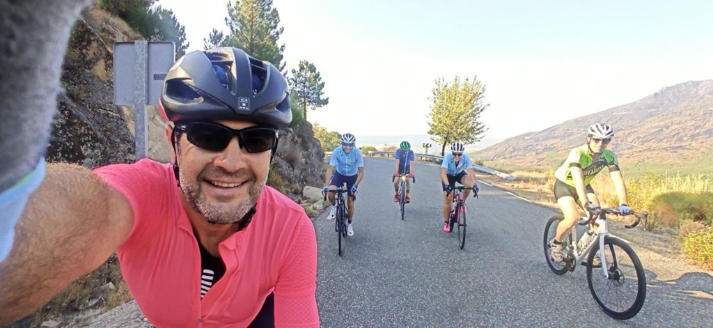
Al pico por el Sidrillo

Road
Road
Ref..: 1064834
Published: 16/08/2022
Performed: 15/08/2022
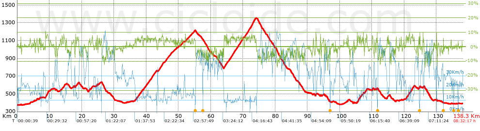
Distance in Km: 138.33
Climb in m: 2534
IBP: 157 BYC


 Height in m      Climb in %      Speed in Km/h      Speed < 2 Km/h

Climbs > 5%

Climbs >5% Climbs >10% Climbs >15% Climbs >20% Climbs >25%
 Steep slope of 194 m.   Average slope  Distances  Download as waypoint
1
 Km 3.997  5%  194 m
 Steep slope of 194 m.  Average slope  Distances  Download as waypoint
2
 Km 6.059  6%  194 m
 Steep slope of 105 m.  Average slope  Distances  Download as waypoint
3
 Km 7.037  5%  105 m
 Steep slope of 967 m.  Average slope  Distances  Download as waypoint
4
 Km 8.8  7%  967 m
 Steep slope of 134 m.  Average slope  Distances  Download as waypoint
5
 Km 13.943  7%  134 m
 Steep slope of 351 m.  Average slope  Distances  Download as waypoint
6
 Km 14.444  7%  351 m
 Steep slope of 145 m.  Average slope  Distances  Download as waypoint
7
 Km 18.087  8%  145 m
 Steep slope of 176 m.  Average slope  Distances  Download as waypoint
8
 Km 18.527  5%  176 m
 Steep slope of 174 m.  Average slope  Distances  Download as waypoint
9
 Km 22.452  7%  174 m
 Steep slope of 211 m.  Average slope  Distances  Download as waypoint
10
 Km 23.102  5%  211 m
 Steep slope of 142 m.  Average slope  Distances  Download as waypoint
11
 Km 24.808  7%  142 m
 Steep slope of 195 m.  Average slope  Distances  Download as waypoint
12
 Km 36.562  6%  195 m
 Steep slope of 101 m.  Average slope  Distances  Download as waypoint
13
 Km 36.996  6%  101 m
 Steep slope of 109 m.  Average slope  Distances  Download as waypoint
14
 Km 37.229  5%  109 m
 Steep slope of 314 m.  Average slope  Distances  Download as waypoint
15
 Km 37.443  6%  314 m
 Steep slope of 94 m.  Average slope  Distances  Download as waypoint
16
 Km 37.852  5%  94 m
 Steep slope of 102 m.  Average slope  Distances  Download as waypoint
17
 Km 38.046  5%  102 m
 Steep slope of 209 m.  Average slope  Distances  Download as waypoint
18
 Km 38.432  6%  209 m
 Steep slope of 100 m.  Average slope  Distances  Download as waypoint
19
 Km 38.738  6%  100 m
 Steep slope of 246 m.  Average slope  Distances  Download as waypoint
20
 Km 39.201  6%  246 m
 Steep slope of 166 m.  Average slope  Distances  Download as waypoint
21
 Km 39.54  5%  166 m
 Steep slope of 202 m.  Average slope  Distances  Download as waypoint
22
 Km 39.849  5%  202 m
 Steep slope of 156 m.  Average slope  Distances  Download as waypoint
23
 Km 40.201  5%  156 m
 Steep slope of 112 m.  Average slope  Distances  Download as waypoint
24
 Km 40.573  5%  112 m
 Steep slope of 182 m.  Average slope  Distances  Download as waypoint
25
 Km 40.79  5%  182 m
 Steep slope of 99 m.  Average slope  Distances  Download as waypoint
26
 Km 41.075  6%  99 m
 Steep slope of 672 m.  Average slope  Distances  Download as waypoint
27
 Km 41.518  6%  672 m
 Steep slope of 148 m.  Average slope  Distances  Download as waypoint
28
 Km 42.474  5%  148 m
 Steep slope of 177 m.  Average slope  Distances  Download as waypoint
29
 Km 42.832  6%  177 m
 Steep slope of 137 m.  Average slope  Distances  Download as waypoint
30
 Km 43.988  6%  137 m
 Steep slope of 336 m.  Average slope  Distances  Download as waypoint
31
 Km 44.233  6%  336 m
 Steep slope of 605 m.  Average slope  Distances  Download as waypoint
32
 Km 44.666  6%  605 m
 Steep slope of 408 m.  Average slope  Distances  Download as waypoint
33
 Km 46.174  6%  408 m
 Steep slope of 136 m.  Average slope  Distances  Download as waypoint
34
 Km 47.453  6%  136 m
 Steep slope of 112 m.  Average slope  Distances  Download as waypoint
35
 Km 47.694  5%  112 m
 Steep slope of 167 m.  Average slope  Distances  Download as waypoint
36
 Km 50.884  6%  167 m
 Steep slope of 104 m.  Average slope  Distances  Download as waypoint
37
 Km 51.154  5%  104 m
 Steep slope of 150 m.  Average slope  Distances  Download as waypoint
38
 Km 52.113  7%  150 m
 Steep slope of 114 m.  Average slope  Distances  Download as waypoint
39
 Km 53.439  5%  114 m
 Steep slope of 97 m.  Average slope  Distances  Download as waypoint
40
 Km 54.177  5%  97 m
 Steep slope of 106 m.  Average slope  Distances  Download as waypoint
41
 Km 54.872  5%  106 m
 Steep slope of 195 m.  Average slope  Distances  Download as waypoint
42
 Km 64.085  7%  195 m
 Steep slope of 404 m.  Average slope  Distances  Download as waypoint
43
 Km 64.48  6%  404 m
 Steep slope of 139 m.  Average slope  Distances  Download as waypoint
44
 Km 65.02  6%  139 m
 Steep slope of 142 m.  Average slope  Distances  Download as waypoint
45
 Km 65.59  5%  142 m
 Steep slope of 140 m.  Average slope  Distances  Download as waypoint
46
 Km 65.934  6%  140 m
 Steep slope of 421 m.  Average slope  Distances  Download as waypoint
47
 Km 66.183  6%  421 m
 Steep slope of 606 m.  Average slope  Distances  Download as waypoint
48
 Km 66.712  6%  606 m
 Steep slope of 227 m.  Average slope  Distances  Download as waypoint
49
 Km 67.421  6%  227 m
 Steep slope of 107 m.  Average slope  Distances  Download as waypoint
50
 Km 68.104  5%  107 m
 Steep slope of 425 m.  Average slope  Distances  Download as waypoint
51
 Km 68.316  6%  425 m
 Steep slope of 594 m.  Average slope  Distances  Download as waypoint
52
 Km 68.913  6%  594 m
 Steep slope of 458 m.  Average slope  Distances  Download as waypoint
53
 Km 69.613  6%  458 m
 Steep slope of 101 m.  Average slope  Distances  Download as waypoint
54
 Km 70.172  7%  101 m
 Steep slope of 442 m.  Average slope  Distances  Download as waypoint
55
 Km 70.614  6%  442 m
 Steep slope of 311 m.  Average slope  Distances  Download as waypoint
56
 Km 71.243  6%  311 m
 Steep slope of 421 m.  Average slope  Distances  Download as waypoint
57
 Km 71.652  7%  421 m
 Steep slope of 1191 m.  Average slope  Distances  Download as waypoint
58
 Km 72.407  7%  1191 m
 Steep slope of 185 m.  Average slope  Distances  Download as waypoint
59
 Km 92.586  8%  185 m
 Steep slope of 116 m.  Average slope  Distances  Download as waypoint
60
 Km 94.035  8%  116 m
 Steep slope of 117 m.  Average slope  Distances  Download as waypoint
61
 Km 94.945  5%  117 m
 Steep slope of 206 m.  Average slope  Distances  Download as waypoint
62
 Km 102.499  7%  206 m
 Steep slope of 106 m.  Average slope  Distances  Download as waypoint
63
 Km 104.283  6%  106 m
 Steep slope of 111 m.  Average slope  Distances  Download as waypoint
64
 Km 105.361  8%  111 m
 Steep slope of 425 m.  Average slope  Distances  Download as waypoint
65
 Km 105.684  7%  425 m
 Steep slope of 178 m.  Average slope  Distances  Download as waypoint
66
 Km 106.364  8%  178 m
 Steep slope of 136 m.  Average slope  Distances  Download as waypoint
67
 Km 106.75  6%  136 m
 Steep slope of 105 m.  Average slope  Distances  Download as waypoint
68
 Km 107.302  9%  105 m
 Steep slope of 169 m.  Average slope  Distances  Download as waypoint
69
 Km 107.951  7%  169 m
 Steep slope of 209 m.  Average slope  Distances  Download as waypoint
70
 Km 108.262  8%  209 m
 Steep slope of 260 m.  Average slope  Distances  Download as waypoint
71
 Km 110.067  7%  260 m
 Steep slope of 155 m.  Average slope  Distances  Download as waypoint
72
 Km 111.444  5%  155 m
 Steep slope of 225 m.  Average slope  Distances  Download as waypoint
73
 Km 114.652  7%  225 m
 Steep slope of 149 m.  Average slope  Distances  Download as waypoint
74
 Km 117.467  7%  149 m
 Steep slope of 212 m.  Average slope  Distances  Download as waypoint
75
 Km 120.52  5%  212 m
 Steep slope of 275 m.  Average slope  Distances  Download as waypoint
76
 Km 120.976  6%  275 m
 Steep slope of 243 m.  Average slope  Distances  Download as waypoint
77
 Km 121.443  7%  243 m
 Steep slope of 566 m.  Average slope  Distances  Download as waypoint
78
 Km 122.101  7%  566 m
 Steep slope of 113 m.  Average slope  Distances  Download as waypoint
79
 Km 122.972  7%  113 m
 Steep slope of 188 m.  Average slope  Distances  Download as waypoint
80
 Km 124.522  7%  188 m
 Steep slope of 132 m.  Average slope  Distances  Download as waypoint
81
 Km 124.814  8%  132 m
 Steep slope of 284 m.  Average slope  Distances  Download as waypoint
82
 Km 125.831  6%  284 m


Description of the route


Presence of ramps


 Climbs  Distance  % of the total  Speed  Your speed would be  Time  Your time would be
   15 - 30%  0  0  0  ?  0:00:00  ?
   10 - 15%  0.659  0.48  13.95  ?  0:02:50  ?
   5 - 10%  22.31  16.13  12.28  ?  1:49:02  ?
   1 - 5%  32.177  23.26  16.44  ?  1:57:28  ?
   Total*  55.146 Km  39.87 %  14.43 Km/h  ? Km/h    3:49:20 h  ? h  
 Flat
   1 - -1%  28.424 Km  20.55 %  27.66 Km/h  ? Km/h    1:01:39 h  ? h  
 Descents
   -1 - -5%  33.869  24.48  38.77  ?  0:52:25  ?
   -5 - -10%  18.028  13.03  47.37  ?  0:22:50  ?
   -10 - -15%  2.686  1.94  50.9  ?  0:03:10  ?
   -15 - -30%  0.175  0.13  42.04  ?  0:00:15  ?
   Total*  54.759 Km  39.59 %  41.77 Km/h  ? Km/h    1:18:40 h  ? h  
* The total has not necessarily coincide with the sum of the partials after correction of errors

How long would it take you?

How long would it take you to cover this route?
There are routes without a valid time information, but with your average stats you can assess the possible duration

Alfonso Puñal to cover this route you've need a time of:   6:09:39 h 
If you sign in and have a minimum of two tracks of this same modality, you can know your time for this route, calculated from your stats..


¿Cuanto consumirá tu E-BIKE?

Entra tu E-IBP (formato n,nn)

E-IBP :   X 157 = 


 Detected activity type =  ()
 Penalization due to track conditions: 36 %   ( > 50 % = MTB, < 50 % = RDB)
 Reliability of the track: A   (2534/79/0/-/-/79)
 Correction level applied to the track: 0
DIFFICULTY OF THE ROUTE
IBP = 157 BYC
According to your statistics
 Your time in motion would be: ? h
Your average speed would be: ? Km/h
 

 Total Distance: 138.33 Km
 Analysed distance: 138.33 Km
 Linear distance: 0.02 Km

 Cumulated positive ramps: 2534.4 m  list of points info
 Cumulated negative ramps: 2511 m
 Maximum height: 1354.2 m
 Minimum height: 373 m
 Climbing Ratio: 4.6 %
 Descent ratio: 4.59 %
 Cumulated postive ramps per Km: 18.32 m
 Cumulated negative ramps per Km: 18.15 m

 Total time: 8:32:17 h
 Time in movement: 6:09:39 h
 According to your statistics
 Your time in motion would be: ? h  
 Stopped time: 2:22:38 h
 Maximum slope filter: ~30 %
 Minimum separation analysed: ~30 m
 Number of points: 10475   (cad. 13.21 m)
 Significant waypoints: 3894   (cad. 35.52 m / 37.17 %)

 Changes in direction per Km: 9.4
 Changes in direction > 5º por Km: 3.8
 Cumulated straight stretches: 60.671 Km
 Straight stretches per Km: 438.6 m
 Penalized slope changes: 19
 Penalized slope changes per Km: 0.137

 Average speed in total: 16.2 Km/h
 Average speed while moving: 22.45 Km/h
 According to your statistics
 Your average speed would be: ? Km/h  
 Maximum sustained speed: 70.87 Km/h


Comments

You can be the first one in commenting this route

 
My comments
:
Add comment  (Registered users)
 
Notify me answers to my comment  Do not notify answers to my comment


Share this route with a friend

Your friend will receive a message with a link to this page:
will see your email and your user name if you do it as registered user.


Write here your name (optional)

E-mail address of your friend(s). You can include various addresses separated by commas

Text or comment (optional) maximum 255 characters long, 255 Available characters

As a non registered users you need to fill-in the captcha text.
  Change image
Type the image characters.
 
 Share with a friend


Visited history

Delete history

Marked routes for review later or compare

My favorites


  Notify anomaly in this route Share in Facebook