Presa del Horcajo.(Piedralaves).

MTB
MTB
Ref..: 1064712
Published: 15/08/2022
Performed: 14/08/2022
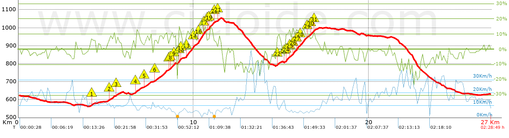
Distance in Km: 26.96
Climb in m: 766
IBP: 65 BYC

Luis del Real
63 published routes

Add to my Group or Club

 Height in m      Climb in %      Speed in Km/h      Speed < 2 Km/h

Climbs > 5%

Climbs >5% Climbs >10% Climbs >15% Climbs >20% Climbs >25%
 Steep slope of 228 m.   Average slope  Distances  Download as waypoint
1
 Km 4.132  6%  228 m
 Steep slope of 348 m.  Average slope  Distances  Download as waypoint
2
 Km 5.145  7%  348 m
 Steep slope of 208 m.  Average slope  Distances  Download as waypoint
3
 Km 5.599  6%  208 m
 Steep slope of 355 m.  Average slope  Distances  Download as waypoint
4
 Km 6.679  7%  355 m
 Steep slope of 363 m.  Average slope  Distances  Download as waypoint
5
 Km 7.2  8%  363 m
 Steep slope of 728 m.  Average slope  Distances  Download as waypoint
6
 Km 7.712  8%  728 m
 Steep slope of 756 m.  Average slope  Distances  Download as waypoint
7
 Km 8.562  7%  139 m
8
 Km 8.701  10%  170 m
9
 Km 8.871  5%  257 m
10
 Km 9.128  13%  157 m
11
 Km 9.285  7%  33 m
 Steep slope of 1749 m.  Average slope  Distances  Download as waypoint
12
 Km 9.501  8%  50 m
13
 Km 9.551  12%  426 m
14
 Km 9.977  9%  221 m
15
 Km 10.198  13%  99 m
16
 Km 10.297  16%  235 m
17
 Km 10.532  13%  183 m
18
 Km 10.715  7%  176 m
19
 Km 10.89  13%  242 m
20
 Km 11.133  6%  117 m
 Steep slope of 141 m.  Average slope  Distances  Download as waypoint
21
 Km 11.355  8%  141 m
 Steep slope of 295 m.  Average slope  Distances  Download as waypoint
22
 Km 14.71  8%  295 m
 Steep slope of 1806 m.  Average slope  Distances  Download as waypoint
23
 Km 15.185  6%  33 m
24
 Km 15.219  12%  235 m
25
 Km 15.454  6%  168 m
26
 Km 15.622  12%  291 m
27
 Km 15.913  11%  192 m
28
 Km 16.105  11%  384 m
29
 Km 16.489  8%  212 m
30
 Km 16.701  10%  134 m
31
 Km 16.835  9%  157 m


Description of the route


Presence of ramps


 Climbs  Distance  % of the total  Speed  Your speed would be  Time  Your time would be
   15 - 30%  0.366  1.36  4.64  ?  0:04:44  ?
   10 - 15%  2.667  9.89  6.14  ?  0:26:04  ?
   5 - 10%  4.156  15.42  8.72  ?  0:28:36  ?
   1 - 5%  2.677  9.93  11.21  ?  0:14:20  ?
   Total*  9.866 Km  36.6 %  8.03 Km/h  ? Km/h    1:13:44 h  ? h  
 Flat
   1 - -1%  5.231 Km  19.4 %  13.54 Km/h  ? Km/h    0:23:11 h  ? h  
 Descents
   -1 - -5%  5.936  22.02  17.43  ?  0:20:26  ?
   -5 - -10%  3.638  13.5  21.3  ?  0:10:15  ?
   -10 - -15%  1.452  5.38  18.8  ?  0:04:38  ?
   -15 - -30%  0.837  3.11  20.51  ?  0:02:27  ?
   Total*  11.863 Km  44 %  18.85 Km/h  ? Km/h    0:37:46 h  ? h  
* The total has not necessarily coincide with the sum of the partials after correction of errors

How long would it take you?

How long would it take you to cover this route?
There are routes without a valid time information, but with your average stats you can assess the possible duration

Luis del Real to cover this route you've need a time of:   2:14:41 h 
If you sign in and have a minimum of two tracks of this same modality, you can know your time for this route, calculated from your stats..


¿Cuanto consumirá tu E-BIKE?

Entra tu E-IBP (formato n,nn)

E-IBP :   X 65 = 


 Detected activity type =  ()
 Penalization due to track conditions: 60 %   ( > 50 % = MTB, < 50 % = RDB)
 Reliability of the track: A   (766/78/0/-/-/78)
 Correction level applied to the track: 0
DIFFICULTY OF THE ROUTE
IBP = 65 BYC
According to your statistics
 Your time in motion would be: ? h
Your average speed would be: ? Km/h
 

 Total Distance: 26.96 Km
 Analysed distance: 26.96 Km
 Linear distance: 0.93 Km

 Cumulated positive ramps: 766.2 m  list of points info
 Cumulated negative ramps: 757.2 m
 Maximum height: 1052.6 m
 Minimum height: 562.4 m
 Climbing Ratio: 7.77 %
 Descent ratio: 6.38 %
 Cumulated postive ramps per Km: 28.42 m
 Cumulated negative ramps per Km: 28.09 m

 Total time: 2:28:49 h
 Time in movement: 2:14:41 h
 According to your statistics
 Your time in motion would be: ? h  
 Stopped time: 0:14:08 h
 Maximum slope filter: ~30 %
 Minimum separation analysed: ~30 m
 Number of points: 975   (cad. 27.65 m)
 Significant waypoints: 571   (cad. 47.21 m / 58.56 %)

 Changes in direction per Km: 9.09
 Changes in direction > 5º por Km: 6.82
 Cumulated straight stretches: 5.046 Km
 Straight stretches per Km: 187.17 m
 Penalized slope changes: 8
 Penalized slope changes per Km: 0.297

 Average speed in total: 10.87 Km/h
 Average speed while moving: 12.01 Km/h
 According to your statistics
 Your average speed would be: ? Km/h  
 Maximum sustained speed: 54.72 Km/h


Comments

You can be the first one in commenting this route

 
My comments
:
Add comment  (Registered users)
 
Notify me answers to my comment  Do not notify answers to my comment


Share this route with a friend

Your friend will receive a message with a link to this page:
will see your email and your user name if you do it as registered user.


Write here your name (optional)

E-mail address of your friend(s). You can include various addresses separated by commas

Text or comment (optional) maximum 255 characters long, 255 Available characters

As a non registered users you need to fill-in the captcha text.
  Change image
Type the image characters.
 
 Share with a friend


Visited history

Delete history

Marked routes for review later or compare

My favorites


  Notify anomaly in this route Share in Facebook