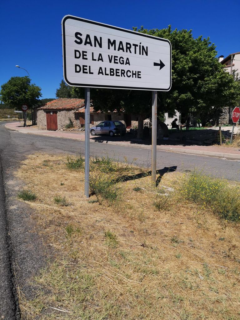
Hoyo del Espino Plataforma San Martín del Pimpollar Hoyo del Espino

MTB
MTB
Ref..: 1064512
Published: 14/08/2022
Performed: 14/08/2022
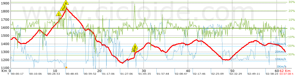
Distance in Km: 62.03
Climb in m: 1428
IBP: 91 BYC

Brujo1971
Author: Brujo1971
417 published routes

Add to my Group or Club

 Height in m      Climb in %      Speed in Km/h      Speed < 2 Km/h

Climbs > 5%

Climbs >5% Climbs >10% Climbs >15% Climbs >20% Climbs >25%
 Steep slope of 96 m.   Average slope  Distances  Download as waypoint
1
 Km 0.292  6%  96 m
 Steep slope of 152 m.  Average slope  Distances  Download as waypoint
2
 Km 3.503  8%  152 m
 Steep slope of 218 m.  Average slope  Distances  Download as waypoint
3
 Km 4.102  6%  218 m
 Steep slope of 470 m.  Average slope  Distances  Download as waypoint
4
 Km 4.696  7%  470 m
 Steep slope of 518 m.  Average slope  Distances  Download as waypoint
5
 Km 5.306  6%  518 m
 Steep slope of 429 m.  Average slope  Distances  Download as waypoint
6
 Km 5.921  8%  266 m
7
 Km 6.187  9%  98 m
8
 Km 6.285  11%  65 m
 Steep slope of 1306 m.  Average slope  Distances  Download as waypoint
9
 Km 8.152  8%  1306 m
 Steep slope of 135 m.  Average slope  Distances  Download as waypoint
10
 Km 9.595  6%  135 m
 Steep slope of 276 m.  Average slope  Distances  Download as waypoint
11
 Km 9.83  7%  276 m
 Steep slope of 102 m.  Average slope  Distances  Download as waypoint
12
 Km 10.202  5%  102 m
 Steep slope of 344 m.  Average slope  Distances  Download as waypoint
13
 Km 10.744  8%  111 m
14
 Km 10.855  10%  100 m
15
 Km 10.955  10%  133 m
 Steep slope of 141 m.  Average slope  Distances  Download as waypoint
16
 Km 11.361  7%  141 m
 Steep slope of 880 m.  Average slope  Distances  Download as waypoint
17
 Km 11.604  8%  98 m
18
 Km 11.703  7%  102 m
19
 Km 11.805  10%  101 m
20
 Km 11.906  11%  131 m
21
 Km 12.037  11%  213 m
22
 Km 12.25  9%  99 m
23
 Km 12.349  7%  67 m
24
 Km 12.416  23%  69 m
 Steep slope of 108 m.  Average slope  Distances  Download as waypoint
25
 Km 17.31  6%  108 m
 Steep slope of 104 m.  Average slope  Distances  Download as waypoint
26
 Km 25.724  7%  104 m
 Steep slope of 164 m.  Average slope  Distances  Download as waypoint
27
 Km 26.065  6%  164 m
 Steep slope of 101 m.  Average slope  Distances  Download as waypoint
28
 Km 26.69  5%  101 m
 Steep slope of 436 m.  Average slope  Distances  Download as waypoint
29
 Km 27.718  6%  116 m
30
 Km 27.834  16%  30 m
31
 Km 27.864  24%  148 m
32
 Km 28.012  17%  63 m
33
 Km 28.076  16%  39 m
34
 Km 28.115  6%  40 m
 Steep slope of 104 m.  Average slope  Distances  Download as waypoint
35
 Km 29.401  7%  104 m
 Steep slope of 737 m.  Average slope  Distances  Download as waypoint
36
 Km 29.84  7%  737 m
 Steep slope of 726 m.  Average slope  Distances  Download as waypoint
37
 Km 35.182  7%  726 m
 Steep slope of 139 m.  Average slope  Distances  Download as waypoint
38
 Km 36.011  5%  139 m
 Steep slope of 111 m.  Average slope  Distances  Download as waypoint
39
 Km 36.259  6%  111 m
 Steep slope of 110 m.  Average slope  Distances  Download as waypoint
40
 Km 37.241  5%  110 m
 Steep slope of 213 m.  Average slope  Distances  Download as waypoint
41
 Km 40.931  6%  213 m
 Steep slope of 279 m.  Average slope  Distances  Download as waypoint
42
 Km 49.578  6%  279 m
 Steep slope of 118 m.  Average slope  Distances  Download as waypoint
43
 Km 49.962  8%  118 m
 Steep slope of 149 m.  Average slope  Distances  Download as waypoint
44
 Km 50.187  6%  149 m
 Steep slope of 270 m.  Average slope  Distances  Download as waypoint
45
 Km 50.623  6%  270 m
 Steep slope of 150 m.  Average slope  Distances  Download as waypoint
46
 Km 51.096  7%  150 m
 Steep slope of 209 m.  Average slope  Distances  Download as waypoint
47
 Km 51.9  7%  209 m
 Steep slope of 131 m.  Average slope  Distances  Download as waypoint
48
 Km 52.212  5%  131 m
 Steep slope of 153 m.  Average slope  Distances  Download as waypoint
49
 Km 52.747  5%  153 m
 Steep slope of 285 m.  Average slope  Distances  Download as waypoint
50
 Km 53.443  7%  285 m
 Steep slope of 116 m.  Average slope  Distances  Download as waypoint
51
 Km 54.761  8%  116 m


Description of the route


Presence of ramps


 Climbs  Distance  % of the total  Speed  Your speed would be  Time  Your time would be
   15 - 30%  0.597  0.96  10.63  ?  0:03:22  ?
   10 - 15%  1.183  1.91  10.37  ?  0:06:51  ?
   5 - 10%  10.645  17.16  13.73  ?  0:46:31  ?
   1 - 5%  14.856  23.95  17.58  ?  0:50:43  ?
   Total*  27.281 Km  43.98 %  15.23 Km/h  ? Km/h    1:47:27 h  ? h  
 Flat
   1 - -1%  7.555 Km  12.18 %  24.46 Km/h  ? Km/h    0:18:32 h  ? h  
 Descents
   -1 - -5%  14.927  24.07  33.25  ?  0:26:56  ?
   -5 - -10%  8.495  13.7  37.21  ?  0:13:42  ?
   -10 - -15%  2.429  3.92  44.84  ?  0:03:15  ?
   -15 - -30%  1.341  2.16  17.94  ?  0:04:29  ?
   Total*  27.192 Km  43.84 %  33.73 Km/h  ? Km/h    0:48:22 h  ? h  
* The total has not necessarily coincide with the sum of the partials after correction of errors

How long would it take you?

How long would it take you to cover this route?
There are routes without a valid time information, but with your average stats you can assess the possible duration

Brujo1971 to cover this route you've need a time of:   2:54:21 h 
If you sign in and have a minimum of two tracks of this same modality, you can know your time for this route, calculated from your stats..


¿Cuanto consumirá tu E-BIKE?

Entra tu E-IBP (formato n,nn)

E-IBP :   X 91 = 


 Detected activity type =  ()
 Penalization due to track conditions: 55 %   ( > 50 % = MTB, < 50 % = RDB)
 Reliability of the track: B   (1430/61/0/-/-/61)
 Correction level applied to the track: 0
DIFFICULTY OF THE ROUTE
IBP = 91 BYC
According to your statistics
 Your time in motion would be: ? h
Your average speed would be: ? Km/h
 

 Total Distance: 62.03 Km
 Analysed distance: 62.03 Km
 Linear distance: 0.02 Km

 Cumulated positive ramps: 1428.38 m  list of points info
 Cumulated negative ramps: 1576.89 m
 Maximum height: 1840.8 m
 Minimum height: 1163.2 m
 Climbing Ratio: 5.24 %
 Descent ratio: 5.8 %
 Cumulated postive ramps per Km: 23.03 m
 Cumulated negative ramps per Km: 25.42 m

 Total time: 3:07:08 h
 Time in movement: 2:54:21 h
 According to your statistics
 Your time in motion would be: ? h  
 Stopped time: 0:12:47 h
 Maximum slope filter: ~30 %
 Minimum separation analysed: ~30 m
 Number of points: 4741   (cad. 13.08 m)
 Significant waypoints: 1756   (cad. 35.32 m / 37.04 %)

 Changes in direction per Km: 8.32
 Changes in direction > 5º por Km: 4.55
 Cumulated straight stretches: 17.469 Km
 Straight stretches per Km: 281.62 m
 Penalized slope changes: 11
 Penalized slope changes per Km: 0.177

 Average speed in total: 19.89 Km/h
 Average speed while moving: 21.35 Km/h
 According to your statistics
 Your average speed would be: ? Km/h  
 Maximum sustained speed: 72.73 Km/h


Comments

You can be the first one in commenting this route

 
My comments
:
Add comment  (Registered users)
 
Notify me answers to my comment  Do not notify answers to my comment


Share this route with a friend

Your friend will receive a message with a link to this page:
will see your email and your user name if you do it as registered user.


Write here your name (optional)

E-mail address of your friend(s). You can include various addresses separated by commas

Text or comment (optional) maximum 255 characters long, 255 Available characters

As a non registered users you need to fill-in the captcha text.
  Change image
Type the image characters.
 
 Share with a friend


Visited history

Delete history

Marked routes for review later or compare

My favorites


  Notify anomaly in this route Share in Facebook