307.Gredos: La Mira (2343 m) por las zetas desde Plataforma Nogal del Barranco

Hiking
Hiking
Ref..: 1054785
Published: 17/06/2022
Performed: 14/05/2022
Distance in Km: 12.03
Climb in m: 1244
IBP: 124 HKG

Carlos Plaza Esteban
260 published routes

Add to my Group or Club

 Height in m      Climb in %      Speed in Km/h      Speed < 2 Km/h


Description of the route

DISTANCIA: 12,03 metros.
TIEMPO: 9 h. 23 min. (5 h. 12 min. en movimiento).
VELOCIDAD MEDIA: 1,28 km/h.
DESNIVEL SUBIDO: 1244,38 metros.
DESNIVEL BAJADO: 1252,94 metros.
PENDIENTE SUBIDA: 20,03 %/km.
PENDIENTE BAJADA: 21,36 %/km.
DIFICULTAD: Moderado.
MATERIAL: Senderismo.
TERRENO: Senderos, senderos con hitos.
INDICE DE ESFUERZO: 124 HKG. MUY DURA. (Condición Física Media).

Mítica ascensión al Pico de La Mira de dificultad en su segunda parte difícil por el desnivel pero la ruta en si es de categoría moderada pero se requiere de cierto fondo físico.

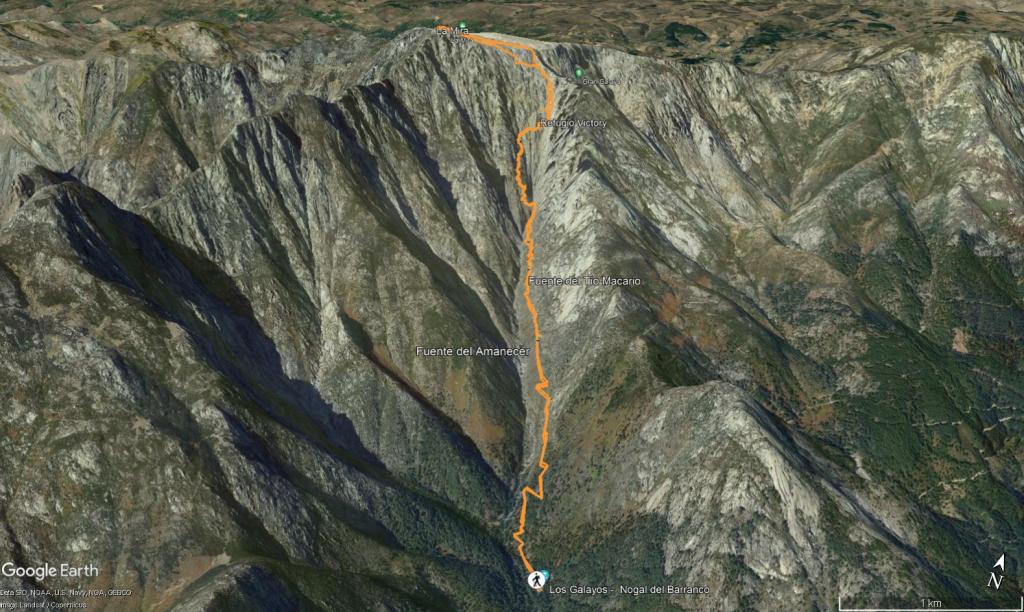
Aparcamos el coche en la plataforma de Guisando o de Nogal del Barranco y cogemos la senda PR-AV 43 que no abandonaremos pasando por las fuentes del Amanecer y del Tío Macario hasta llegar a la siguiente intersección en la cual da a elegir subir por la Apretura o por las Zetas, cogemos el camino de la izquierda por la zetas y subimos hasta el refugio Victory bien señalizado con hitos por lo que no hay perdida.

En el refugio, parada para reponer fuerzas y vistas espectaculares a los Galayos viendo a la gente escalando por sus paredes, giramos a la derecha del refugio por detrás y ascendemos por un canchal de piedras grandes que cuesta bastante subir, por lo que se recomienda tener buen fondo físico o con paciencia, el camino esta marcado por muchos hitos se puede subir por cualquier parte, toda esta parte es difícil por la pendiente, nosotros subimos por el camino mas pegado a la derecha y subimos al ultimo hito, allí giramos a la izquierda y la pendiente es muy suave y casi un paseo hasta la mira que estará sobre unos 500-600 metros, el esfuerzo tiene como recompensa las impresionantes vistas.

La vuelta la hacemos siguiendo unos hitos nada más bajar a la derecha del geodésico, es una bajada más técnica y abstenerse de bajar por ella con nieve o hielo pues es algo peligrosa por lo resbaladizo de la piedra, más adelante engancha con el mismo camino de la subida siguiendo los hitos.

Siguiendo el track no hay perdida. Nos vemos en la Montañas!!.


Presence of ramps


 Climbs  Distance  % of the total  Speed  Your speed would be  Time  Your time would be
   15 - 30%  3.263  27.12  2.04  ?  1:36:04  ?
   10 - 15%  1.49  12.38  2.51  ?  0:35:39  ?
   5 - 10%  0.259  2.16  3.29  ?  0:04:44  ?
   1 - 5%  0.167  1.39  5.1  ?  0:01:58  ?
   Total*  6.131 Km  50.96 %  2.2 Km/h  ? Km/h    2:47:24 h  ? h  
 Flat
   1 - -1%  0.034 Km  0.28 %  1.29 Km/h  ? Km/h    0:01:35 h  ? h  
 Descents
   -1 - -5%  0  0  0  ?  0:00:00  ?
   -5 - -10%  0.338  2.81  3.07  ?  0:06:36  ?
   -10 - -15%  1.359  11.29  3.14  ?  0:26:00  ?
   -15 - -30%  3.041  25.28  2.59  ?  1:10:24  ?
   Total*  5.867 Km  48.76 %  2.45 Km/h  ? Km/h    2:23:48 h  ? h  
* The total has not necessarily coincide with the sum of the partials after correction of errors

How long would it take you?

How long would it take you to cover this route?
There are routes without a valid time information, but with your average stats you can assess the possible duration

Carlos Plaza Esteban to cover this route you've need a time of:   5:12:47 h 
If you sign in and have a minimum of two tracks of this same modality, you can know your time for this route, calculated from your stats..


 Detected activity type =  ()
 Penalization due to track conditions: 0 %   ( > 50 % = MTB, < 50 % = RDB)
 Reliability of the track: A   (1244/100/0/-/-/100)
 Correction level applied to the track: 0
DIFFICULTY OF THE ROUTE
IBP = 124 HKG
According to your statistics
 Your time in motion would be: ? h
Your average speed would be: ? Km/h
 

 Total Distance: 12.03 Km
 Analysed distance: 12.03 Km
 Linear distance: 0.01 Km

 Cumulated positive ramps: 1244.41 m  list of points info
 Cumulated negative ramps: 1253 m
 Maximum height: 2345.24 m
 Minimum height: 1102.01 m
 Climbing Ratio: 20.3 %
 Descent ratio: 21.36 %
 Cumulated postive ramps per Km: 103.44 m
 Cumulated negative ramps per Km: 104.16 m

 Total time: 9:23:51 h
 Time in movement: 5:12:47 h
 According to your statistics
 Your time in motion would be: ? h  
 Stopped time: 4:11:04 h
 Maximum slope filter: ~55 %
 Minimum separation analysed: ~30 m
 Number of points: 242   (cad. 49.72 m)
 Significant waypoints: 173   (cad. 69.55 m / 71.49 %)

 Changes in direction per Km: 10.81
 Changes in direction > 5º por Km: 10.14
 Cumulated straight stretches: 0.149 Km
 Straight stretches per Km: 12.39 m
 Penalized slope changes: 5
 Penalized slope changes per Km: 0.416

 Average speed in total: 1.28 Km/h
 Average speed while moving: 2.31 Km/h
 According to your statistics
 Your average speed would be: ? Km/h  
 Maximum sustained speed: 4.36 Km/h


Comments

You can be the first one in commenting this route

 
My comments
:
Add comment  (Registered users)
 
Notify me answers to my comment  Do not notify answers to my comment


Share this route with a friend

Your friend will receive a message with a link to this page:
will see your email and your user name if you do it as registered user.


Write here your name (optional)

E-mail address of your friend(s). You can include various addresses separated by commas

Text or comment (optional) maximum 255 characters long, 255 Available characters

As a non registered users you need to fill-in the captcha text.
  Change image
Type the image characters.
 
 Share with a friend


Visited history

Delete history

Marked routes for review later or compare

My favorites


  Notify anomaly in this route Share in Facebook