306.Cabeza de Renales (1757 m)-Majada del Brezo

Hiking
Hiking
Ref..: 1054784
Published: 17/06/2022
Performed: 08/05/2022
Distance in Km: 12.95
Climb in m: 675
IBP: 81 HKG

Carlos Plaza Esteban
260 published routes

Add to my Group or Club

 Height in m      Climb in %      Speed in Km/h      Speed < 2 Km/h


Description of the route

DISTANCIA: 12,95 km.
TIEMPO: 6 h. 17 min. (3 h. 44 min. en movimiento).
VELOCIDAD MEDIA: 2,06 km/h.
DESNIVEL SUBIDO: 674,9 metros.
DESNIVEL BAJADO: 672,6 metros.
PORCENTAJE SUBIDA: 11,83 %/km.
PORCENTAJE BAJADA: 10,18 %/km.
DIFICULTAD: Fácil.
MATERIAL: Senderismo.
TERRENO: Pista, senderos, campo a través.
INDICE DE ESFUERZO: 81 HKG. DURA. (Condición Física Media).

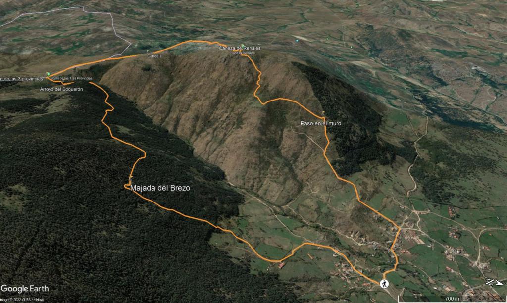
Aparcamos a unos 300 metros de la plaza de Toros en una pista y giramos a la derecha para seguir por otra pista bajando un poco y subiendo entre fincas de ganado, después giramos a la izquierda y cogemos pista que iremos subiendo por ella salvando un importante desnivel, llegamos a una puerta de color rojo que pone que es una finca privada, saltamos un pequeño muro de piedra a nuestra derecha y seguiremos un sendero "pisado" y pegado al muro que iremos ascendiendo por el adquiriendo bastante altura.

Volvemos a pasar por el muro a la izquierda con una pequeña trepada y nos metemos en la pista o sendero ancho que dejamos un poco más abajo, lo seguiremos subiendo ligeramente por él y llegamos a una gran campa, a partir de aquí recomiendo seguir mi track ya que en mi mapa si hay un sendero pero al no estar transitado se pierde. Buscamos el mejor camino posible y empezamos a ascender ganando bastante desnivel hasta alcanzar el geodésico de Cabeza Renales (1757 m) dónde observamos parte de la Mujer Muerta, Bola, Peñota, más a la derecha tenemos Cueva Valiente y Cabeza Lijar y a nuestras espaldas a lo lejos se divisa el Circo de Gredos, etc. Procedemos a descansar y parar a comer.

Después seguimos un poco de campo a través enlazando con un pequeño sendero a nuestra derecha y vamos llaneando-bajando un poco, pasamos por una entrada grande en el muro de piedra y seguiremos paralelos a este por la derecha bajando por un sendero que se pierde alguna vez y en algún tramo un poco empinado hasta llegar al Camino de Peguerinos que cogeremos a mano izquierda y tras pasar por una cancela ascenderemos suavemente por él durante casi 1 km. Llegamos al Mojón de las 3 Provincias, indicando en que provincia te encuentras pasando las cancelas y el muro de piedra, cruzamos por una cancela y seguimos a la izquierda en fuerte pendiente cogiendo el Camino de Santa Quiteria que bajaremos un poco, después nos desviamos por entre el pinar a la derecha, cruzaremos el arroyo del Boquerón y seguimos el Camino de los Ingenieros (un precioso sendero y en mucho tramo muy llano), hasta la Majada del Brezo.

Una vez aquí bajamos a la izquierda dejando el Camino de los Ingenieros por un pequeño campo a través enlazando más abajo por un reguero (en el mapa viene como camino) que iremos paralelos a él ya que baja agua, comenzamos una buena bajada hasta llegar a una pequeña pista la cuál seguiremos hasta alcanzar el coche.

Nos vemos en las Montañas!!.


Presence of ramps


 Climbs  Distance  % of the total  Speed  Your speed would be  Time  Your time would be
   15 - 30%  1.461  11.28  2.05  ?  0:42:41  ?
   10 - 15%  0.96  7.41  4  ?  0:14:24  ?
   5 - 10%  1.402  10.83  3.77  ?  0:22:18  ?
   1 - 5%  1.551  11.97  4.17  ?  0:22:20  ?
   Total*  5.706 Km  44.06 %  3.12 Km/h  ? Km/h    1:49:53 h  ? h  
 Flat
   1 - -1%  0.639 Km  4.93 %  4.09 Km/h  ? Km/h    0:09:22 h  ? h  
 Descents
   -1 - -5%  1.792  13.84  4.44  ?  0:24:14  ?
   -5 - -10%  2.672  20.63  4.09  ?  0:39:11  ?
   -10 - -15%  0.657  5.07  3.64  ?  0:10:49  ?
   -15 - -30%  1.275  9.84  3  ?  0:25:28  ?
   Total*  6.605 Km  51.01 %  3.77 Km/h  ? Km/h    1:45:08 h  ? h  
* The total has not necessarily coincide with the sum of the partials after correction of errors

How long would it take you?

How long would it take you to cover this route?
There are routes without a valid time information, but with your average stats you can assess the possible duration

Carlos Plaza Esteban to cover this route you've need a time of:   3:44:23 h 
If you sign in and have a minimum of two tracks of this same modality, you can know your time for this route, calculated from your stats..


 Detected activity type =  ()
 Penalization due to track conditions: 0 %   ( > 50 % = MTB, < 50 % = RDB)
 Reliability of the track: A   (675/86/0/-/-/86)
 Correction level applied to the track: 0
DIFFICULTY OF THE ROUTE
IBP = 81 HKG
According to your statistics
 Your time in motion would be: ? h
Your average speed would be: ? Km/h
 

 Total Distance: 12.95 Km
 Analysed distance: 12.95 Km
 Linear distance: 0 Km

 Cumulated positive ramps: 674.84 m  list of points info
 Cumulated negative ramps: 672.63 m
 Maximum height: 1753.21 m
 Minimum height: 1220.82 m
 Climbing Ratio: 11.83 %
 Descent ratio: 10.18 %
 Cumulated postive ramps per Km: 52.11 m
 Cumulated negative ramps per Km: 51.94 m

 Total time: 6:17:00 h
 Time in movement: 3:44:23 h
 According to your statistics
 Your time in motion would be: ? h  
 Stopped time: 2:32:37 h
 Maximum slope filter: ~55 %
 Minimum separation analysed: ~30 m
 Number of points: 146   (cad. 88.7 m)
 Significant waypoints: 131   (cad. 98.86 m / 89.73 %)

 Changes in direction per Km: 5.64
 Changes in direction > 5º por Km: 5.56
 Cumulated straight stretches: 0.307 Km
 Straight stretches per Km: 23.71 m
 Penalized slope changes: 8
 Penalized slope changes per Km: 0.618

 Average speed in total: 2.06 Km/h
 Average speed while moving: 3.46 Km/h
 According to your statistics
 Your average speed would be: ? Km/h  
 Maximum sustained speed: 5.02 Km/h


Comments

You can be the first one in commenting this route

 
My comments
:
Add comment  (Registered users)
 
Notify me answers to my comment  Do not notify answers to my comment


Share this route with a friend

Your friend will receive a message with a link to this page:
will see your email and your user name if you do it as registered user.


Write here your name (optional)

E-mail address of your friend(s). You can include various addresses separated by commas

Text or comment (optional) maximum 255 characters long, 255 Available characters

As a non registered users you need to fill-in the captcha text.
  Change image
Type the image characters.
 
 Share with a friend


Visited history

Delete history

Marked routes for review later or compare

My favorites


  Notify anomaly in this route Share in Facebook