288.Dinosaurio de la Maliciosa-Tiburón desde Urb. Vista Real

Hiking
Hiking
Ref..: 1054003
Published: 13/06/2022
Performed: 12/12/2021
Distance in Km: 8.26
Climb in m: 586
IBP: 65 HKG

Carlos Plaza Esteban
260 published routes

Add to my Group or Club

 Height in m      Climb in %      Speed in Km/h      Speed < 2 Km/h


Description of the route

DISTANCIA: 8,26 km.
VELOCIDAD MEDIA: 1,42 km/h.
TIEMPO: 5 h. 49 min. (2 h. 51 min. en movimiento).
DESNIVEL SUBIDA: 586.1 metros.
DESNIVEL BAJADA: 612,2 metros.
RATIO SUBIDA: 14,69 %.
RATIO BAJADA: 14,93 %.
DIFICULTAD: Fácil.
MATERIAL: Senderismo.
TERRENO: Pista, senderos, senderos con hitos.
INDICE DE ESFUERZO: 65 HKG. MEDIA. (Condición Física Media).

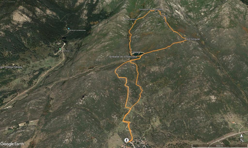
Dejamos el coche al final de la calle Vista Real, muy cerca de la cancela, seguimos la pista remontando una pequeña loma hasta el Embalse de La Maliciosa. Son unos 260 metros de desnivel, en poco más de 2 kilómetros por pista que se hacen un poco pesados. En este tramo tienes pequeñas sendas y atajos que puedes seguir para subir más cómodo. Siempre tenemos las vistas de la Mali al fondo.
Pasamos la segunda cancela, y rodeamos el Embalse de La Maliciosa para seguir el camino paralelo al Arroyo Peña Jardinera que hemos cogido tantas veces de subida a nuestra querida Mali.

A 1,5 km desde el embalse nos desviamos a la derecha para atacar la última subida. Son poco más de 100 m de desnivel con senda marcada. Tendremos alguna trepadilla que otra para llegar a nuestro objetivo. Unas fotos y seguimos el camino por la Cuerda de los Asientos, La bajada por la cuerda tiene unas vistas preciosas, pasamos por otra de las formaciones curiosas El Tiburón, donde hicimos unas fotos graciosas.

Seguimos cuerda, y antes de llegar al Pico Jarator nos desviamos a la derecha por la senda de bajada entre jaras hasta dar con el acceso de la valla al Embalse de la Maliciosa.
Desde aquí seguimos la pista hasta cruzar la cancela donde nos desviamos a la izquierda por una senda marcada entre jaras y escoberas.
La bajada en algunos tramos es algo escarpada, siguiendo la canalización de agua del embalse. Los palos vienen muy bien para no resbalar.
Siempre puedes bajar por la pista si no te gusta complicarte mucho el paso entre las jaras, cuando coincidimos con la pista seguimos la senda paralela hasta llegar al coche y dar por concluida esta ruta alternativa de subida al Dino de la Mali.

Nos vemos en las Montañas!!.


Presence of ramps


 Climbs  Distance  % of the total  Speed  Your speed would be  Time  Your time would be
   15 - 30%  1.515  18.34  2.37  ?  0:38:17  ?
   10 - 15%  0.936  11.33  2.82  ?  0:19:54  ?
   5 - 10%  0.902  10.92  3.16  ?  0:17:07  ?
   1 - 5%  0.418  5.06  3.29  ?  0:07:37  ?
   Total*  3.991 Km  48.3 %  2.8 Km/h  ? Km/h    1:25:36 h  ? h  
 Flat
   1 - -1%  0.241 Km  2.92 %  2.53 Km/h  ? Km/h    0:05:43 h  ? h  
 Descents
   -1 - -5%  0.371  4.49  3.75  ?  0:05:56  ?
   -5 - -10%  0.802  9.71  3.32  ?  0:14:30  ?
   -10 - -15%  0.971  11.75  3.62  ?  0:16:07  ?
   -15 - -30%  1.843  22.3  2.62  ?  0:42:09  ?
   Total*  4.03 Km  48.78 %  3.01 Km/h  ? Km/h    1:20:14 h  ? h  
* The total has not necessarily coincide with the sum of the partials after correction of errors

How long would it take you?

How long would it take you to cover this route?
There are routes without a valid time information, but with your average stats you can assess the possible duration

Carlos Plaza Esteban to cover this route you've need a time of:   2:51:33 h 
If you sign in and have a minimum of two tracks of this same modality, you can know your time for this route, calculated from your stats..


 Detected activity type =  ()
 Penalization due to track conditions: 0 %   ( > 50 % = MTB, < 50 % = RDB)
 Reliability of the track: A   (586/98/0/-/-/98)
 Correction level applied to the track: 0
DIFFICULTY OF THE ROUTE
IBP = 65 HKG
According to your statistics
 Your time in motion would be: ? h
Your average speed would be: ? Km/h
 

 Total Distance: 8.26 Km
 Analysed distance: 8.26 Km
 Linear distance: 0.03 Km

 Cumulated positive ramps: 586.15 m  list of points info
 Cumulated negative ramps: 611.59 m
 Maximum height: 1731.5 m
 Minimum height: 1132.33 m
 Climbing Ratio: 14.69 %
 Descent ratio: 15.18 %
 Cumulated postive ramps per Km: 70.96 m
 Cumulated negative ramps per Km: 74.04 m

 Total time: 5:49:50 h
 Time in movement: 2:51:33 h
 According to your statistics
 Your time in motion would be: ? h  
 Stopped time: 2:58:17 h
 Maximum slope filter: ~55 %
 Minimum separation analysed: ~30 m
 Number of points: 131   (cad. 63.07 m)
 Significant waypoints: 107   (cad. 77.22 m / 81.68 %)

 Changes in direction per Km: 8.23
 Changes in direction > 5º por Km: 7.99
 Cumulated straight stretches: 0.221 Km
 Straight stretches per Km: 26.76 m
 Penalized slope changes: 3
 Penalized slope changes per Km: 0.363

 Average speed in total: 1.42 Km/h
 Average speed while moving: 2.89 Km/h
 According to your statistics
 Your average speed would be: ? Km/h  
 Maximum sustained speed: 4.92 Km/h


Comments

You can be the first one in commenting this route

 
My comments
:
Add comment  (Registered users)
 
Notify me answers to my comment  Do not notify answers to my comment


Share this route with a friend

Your friend will receive a message with a link to this page:
will see your email and your user name if you do it as registered user.


Write here your name (optional)

E-mail address of your friend(s). You can include various addresses separated by commas

Text or comment (optional) maximum 255 characters long, 255 Available characters

As a non registered users you need to fill-in the captcha text.
  Change image
Type the image characters.
 
 Share with a friend


Visited history

Delete history

Marked routes for review later or compare

My favorites


  Notify anomaly in this route Share in Facebook