275.Pirineos: Tres Cascadas desde Cerler

Hiking
Hiking
Ref..: 1051737
Published: 06/06/2022
Performed: 21/08/2021
Distance in Km: 7.76
Climb in m: 285
IBP: 47 HKG

Carlos Plaza Esteban
260 published routes

Add to my Group or Club

 Height in m      Climb in %      Speed in Km/h      Speed < 2 Km/h


Description of the route

DISTANCIA: 7,76 km.
VELOCIDAD MEDIA: 1,31 km/h.
5 h. 56 min. (2 h. 29 min. en movimiento, nosotros paramos mucho).
DESNIVEL SUBIDA: 285,45 metros.
DESNIVEL BAJADA: 296,1 metros.
RATIO SUBIDA: 8,12 %.
RATIO BAJADA: 8,39%.
DIFICULTAD: Fácil.
MATERIAL: Senderismo.
TERRENO: Senderos (PR).
INDICE DE ESFUERZO: 47 HKG. FACIL. (Condición Física Media).

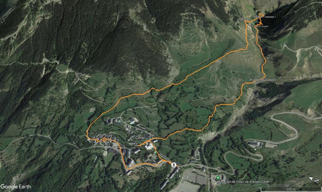
Se trata de una ruta sencilla que parte del pueblo de Cerler. Todo el recorrido está balizado y bien indicado.
Al principio de la ruta, pasamos por la Ermita de S.Pedro.
Continuamos caminando hasta una zona abierta cercana al río Ardonés. Seguimos caminando en ascenso hacía un sendero más estrecho que nos llevará a la Cascada de Ardonés. Es una zona boscosa y más sombría que tiene restos de nieve en el día de hoy y zona con barro, por lo que tenemos que llevar buen calzado y caminar con cuidado para evitar resbalones.

Llegaremos a los pies de la cascada, y cruzaremos un puente para continuar con la circular. En ese punto, una sirga nos ayudará en un paso un pelín complicado pero que con cuidado no tiene dificultad. Es una zona de roca que siempre suele estar mojada por estar cerca de la cascada. Esta cascada es la mas bonita de las 3; el caudal de agua es más abundante y por tanto impresiona más que las otras dos. En esta época del año (agosto) solo encontramos agua abundante en esta tercera cascada, la 2 y la 1 sólo tenían un hilillo de agua.

Después simplemente hay que continuar por el sendero indicado hasta llegar hasta el pueblo de Cerler, vemos a mitad de camino una cascada a la derecha que sale por debajo de un monticulo y es espectacular, seguimos después el sendero que nos llevará a Cerler.

Nosotros aprovechamos para atravesar el pueblo y visitarlo. Pasamos por la Iglesia de S. Lorenzo, el lavadero... Cerler es muy bonito.

Nos vemos en las Montañas!!.


Presence of ramps


 Climbs  Distance  % of the total  Speed  Your speed would be  Time  Your time would be
   15 - 30%  0.218  2.81  4.46  ?  0:02:56  ?
   10 - 15%  1.259  16.22  3.1  ?  0:24:20  ?
   5 - 10%  1.29  16.62  3.05  ?  0:25:23  ?
   1 - 5%  0.747  9.62  3.51  ?  0:12:46  ?
   Total*  3.514 Km  45.27 %  3.22 Km/h  ? Km/h    1:05:25 h  ? h  
 Flat
   1 - -1%  0.764 Km  9.84 %  3.37 Km/h  ? Km/h    0:13:37 h  ? h  
 Descents
   -1 - -5%  0.828  10.67  3.15  ?  0:15:47  ?
   -5 - -10%  1.741  22.43  3.32  ?  0:31:27  ?
   -10 - -15%  0.455  5.87  2.52  ?  0:10:51  ?
   -15 - -30%  0.461  5.93  2.18  ?  0:12:42  ?
   Total*  3.485 Km  44.89 %  2.95 Km/h  ? Km/h    1:10:47 h  ? h  
* The total has not necessarily coincide with the sum of the partials after correction of errors

How long would it take you?

How long would it take you to cover this route?
There are routes without a valid time information, but with your average stats you can assess the possible duration

Carlos Plaza Esteban to cover this route you've need a time of:   2:29:49 h 
If you sign in and have a minimum of two tracks of this same modality, you can know your time for this route, calculated from your stats..


 Detected activity type =  ()
 Penalization due to track conditions: 0 %   ( > 50 % = MTB, < 50 % = RDB)
 Reliability of the track: C   (332/50/1/16/-/65)
 Correction level applied to the track: 1        See analyis without corrections
DIFFICULTY OF THE ROUTE
IBP = 47 HKG
According to your statistics
 Your time in motion would be: ? h
Your average speed would be: ? Km/h
 

 Total Distance: 7.76 Km
 Analysed distance: 7.76 Km
 Linear distance: 0.02 Km

 Cumulated positive ramps: 285.32 m  list of points info
 Cumulated negative ramps: 295.81 m
 Maximum height: 1781.88 m
 Minimum height: 1518.48 m
 Climbing Ratio: 8.12 %
 Descent ratio: 8.49 %
 Cumulated postive ramps per Km: 36.77 m
 Cumulated negative ramps per Km: 38.12 m

 Total time: 5:56:29 h
 Time in movement: 2:29:49 h
 According to your statistics
 Your time in motion would be: ? h  
 Stopped time: 3:26:40 h
 Maximum slope filter: ~55 %
 Minimum separation analysed: ~30 m
 Number of points: 374   (cad. 20.76 m)
 Significant waypoints: 187   (cad. 41.51 m / 50 %)

 Changes in direction per Km: 12.63
 Changes in direction > 5º por Km: 10.57
 Cumulated straight stretches: 0.538 Km
 Straight stretches per Km: 69.33 m
 Penalized slope changes: 1
 Penalized slope changes per Km: 0.129

 Average speed in total: 1.31 Km/h
 Average speed while moving: 3.11 Km/h
 According to your statistics
 Your average speed would be: ? Km/h  
 Maximum sustained speed: 5.98 Km/h


Comments

You can be the first one in commenting this route

 
My comments
:
Add comment  (Registered users)
 
Notify me answers to my comment  Do not notify answers to my comment


Share this route with a friend

Your friend will receive a message with a link to this page:
will see your email and your user name if you do it as registered user.


Write here your name (optional)

E-mail address of your friend(s). You can include various addresses separated by commas

Text or comment (optional) maximum 255 characters long, 255 Available characters

As a non registered users you need to fill-in the captcha text.
  Change image
Type the image characters.
 
 Share with a friend


Visited history

Delete history

Marked routes for review later or compare

My favorites


  Notify anomaly in this route Share in Facebook