Cabrerès 2022

MTB
MTB
Ref..: 1050066
Published: 30/05/2022
Performed: 29/05/2022
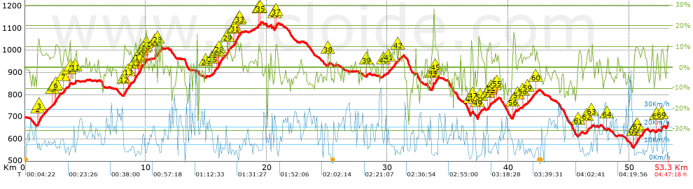
Distance in Km: 53.34
Climb in m: 1500
IBP: 111 BYC

Juan Ramón
Author: Juan Ramón
341 published routes

Add to my Group or Club

 Height in m      Climb in %      Speed in Km/h      Speed < 2 Km/h

Climbs > 5%

Climbs >5% Climbs >10% Climbs >15% Climbs >20% Climbs >25%
 Steep slope of 998 m.   Average slope  Distances  Download as waypoint
1
 Km 1.021  10%  35 m
2
 Km 1.056  13%  100 m
3
 Km 1.156  7%  863 m
 Steep slope of 658 m.  Average slope  Distances  Download as waypoint
4
 Km 2.265  6%  241 m
5
 Km 2.506  11%  106 m
6
 Km 2.612  9%  311 m
 Steep slope of 243 m.  Average slope  Distances  Download as waypoint
7
 Km 3.21  9%  243 m
 Steep slope of 180 m.  Average slope  Distances  Download as waypoint
8
 Km 3.632  7%  48 m
9
 Km 3.68  13%  97 m
10
 Km 3.777  7%  35 m
 Steep slope of 136 m.  Average slope  Distances  Download as waypoint
11
 Km 4.141  8%  136 m
 Steep slope of 273 m.  Average slope  Distances  Download as waypoint
12
 Km 8.157  9%  273 m
 Steep slope of 775 m.  Average slope  Distances  Download as waypoint
13
 Km 8.533  7%  531 m
14
 Km 9.064  11%  145 m
15
 Km 9.209  8%  99 m
 Steep slope of 382 m.  Average slope  Distances  Download as waypoint
16
 Km 9.413  5%  32 m
17
 Km 9.445  13%  252 m
18
 Km 9.697  8%  98 m
 Steep slope of 211 m.  Average slope  Distances  Download as waypoint
19
 Km 9.907  7%  35 m
20
 Km 9.942  12%  105 m
21
 Km 10.047  13%  71 m
 Steep slope of 108 m.  Average slope  Distances  Download as waypoint
22
 Km 10.773  11%  108 m
 Steep slope of 143 m.  Average slope  Distances  Download as waypoint
23
 Km 10.984  14%  143 m
 Steep slope of 112 m.  Average slope  Distances  Download as waypoint
24
 Km 14.967  6%  112 m
 Steep slope of 234 m.  Average slope  Distances  Download as waypoint
25
 Km 15.49  8%  234 m
 Steep slope of 843 m.  Average slope  Distances  Download as waypoint
26
 Km 15.824  5%  143 m
27
 Km 15.967  12%  134 m
28
 Km 16.102  7%  566 m
 Steep slope of 309 m.  Average slope  Distances  Download as waypoint
29
 Km 16.775  10%  309 m
 Steep slope of 701 m.  Average slope  Distances  Download as waypoint
30
 Km 17.22  6%  168 m
31
 Km 17.389  12%  209 m
32
 Km 17.597  8%  136 m
33
 Km 17.734  8%  188 m
 Steep slope of 221 m.  Average slope  Distances  Download as waypoint
34
 Km 19.345  11%  151 m
35
 Km 19.496  9%  70 m
 Steep slope of 222 m.  Average slope  Distances  Download as waypoint
36
 Km 20.655  6%  71 m
37
 Km 20.726  12%  151 m
 Steep slope of 207 m.  Average slope  Distances  Download as waypoint
38
 Km 25.062  7%  207 m
 Steep slope of 139 m.  Average slope  Distances  Download as waypoint
39
 Km 28.276  7%  139 m
 Steep slope of 107 m.  Average slope  Distances  Download as waypoint
40
 Km 29.639  7%  107 m
 Steep slope of 661 m.  Average slope  Distances  Download as waypoint
41
 Km 30.059  7%  661 m
 Steep slope of 169 m.  Average slope  Distances  Download as waypoint
42
 Km 30.893  8%  169 m
 Steep slope of 487 m.  Average slope  Distances  Download as waypoint
43
 Km 33.678  8%  68 m
44
 Km 33.746  13%  212 m
45
 Km 33.959  9%  207 m
 Steep slope of 158 m.  Average slope  Distances  Download as waypoint
46
 Km 36.896  12%  124 m
47
 Km 37.02  6%  34 m
 Steep slope of 360 m.  Average slope  Distances  Download as waypoint
48
 Km 37.48  10%  32 m
49
 Km 37.513  14%  157 m
50
 Km 37.669  7%  171 m
 Steep slope of 337 m.  Average slope  Distances  Download as waypoint
51
 Km 38.231  8%  201 m
52
 Km 38.432  11%  104 m
53
 Km 38.536  11%  32 m
 Steep slope of 99 m.  Average slope  Distances  Download as waypoint
54
 Km 38.854  7%  99 m
 Steep slope of 97 m.  Average slope  Distances  Download as waypoint
55
 Km 39.088  5%  97 m
 Steep slope of 263 m.  Average slope  Distances  Download as waypoint
56
 Km 40.366  14%  263 m
 Steep slope of 104 m.  Average slope  Distances  Download as waypoint
57
 Km 40.809  5%  104 m
 Steep slope of 203 m.  Average slope  Distances  Download as waypoint
58
 Km 41.16  6%  203 m
 Steep slope of 590 m.  Average slope  Distances  Download as waypoint
59
 Km 41.532  7%  590 m
 Steep slope of 110 m.  Average slope  Distances  Download as waypoint
60
 Km 42.252  6%  110 m
 Steep slope of 307 m.  Average slope  Distances  Download as waypoint
61
 Km 45.793  7%  307 m
 Steep slope of 233 m.  Average slope  Distances  Download as waypoint
62
 Km 46.5  8%  233 m
 Steep slope of 102 m.  Average slope  Distances  Download as waypoint
63
 Km 46.873  8%  102 m
 Steep slope of 106 m.  Average slope  Distances  Download as waypoint
64
 Km 48.154  5%  106 m
 Steep slope of 909 m.  Average slope  Distances  Download as waypoint
65
 Km 50.352  7%  214 m
66
 Km 50.566  10%  97 m
67
 Km 50.663  8%  598 m
 Steep slope of 118 m.  Average slope  Distances  Download as waypoint
68
 Km 52.278  7%  118 m
 Steep slope of 232 m.  Average slope  Distances  Download as waypoint
69
 Km 52.648  9%  232 m


Description of the route


Presence of ramps


 Climbs  Distance  % of the total  Speed  Your speed would be  Time  Your time would be
   15 - 30%  0.759  1.42  6.96  ?  0:06:33  ?
   10 - 15%  3.19  5.98  6.43  ?  0:29:46  ?
   5 - 10%  9.918  18.6  8.25  ?  1:12:06  ?
   1 - 5%  9.326  17.49  11.26  ?  0:49:41  ?
   Total*  23.195 Km  43.49 %  8.8 Km/h  ? Km/h    2:38:06 h  ? h  
 Flat
   1 - -1%  5.721 Km  10.73 %  15.87 Km/h  ? Km/h    0:21:38 h  ? h  
 Descents
   -1 - -5%  10.97  20.57  17.61  ?  0:37:23  ?
   -5 - -10%  9.719  18.22  17.8  ?  0:32:46  ?
   -10 - -15%  2.616  4.91  15.83  ?  0:09:55  ?
   -15 - -30%  1.118  2.1  12.12  ?  0:05:32  ?
   Total*  24.423 Km  45.79 %  17.12 Km/h  ? Km/h    1:25:36 h  ? h  
* The total has not necessarily coincide with the sum of the partials after correction of errors

How long would it take you?

How long would it take you to cover this route?
There are routes without a valid time information, but with your average stats you can assess the possible duration

Juan Ramón to cover this route you've need a time of:   4:25:20 h 
If you sign in and have a minimum of two tracks of this same modality, you can know your time for this route, calculated from your stats..


¿Cuanto consumirá tu E-BIKE?

Entra tu E-IBP (formato n,nn)

E-IBP :   X 111 = 


 Detected activity type =  ()
 Penalization due to track conditions: 74 %   ( > 50 % = MTB, < 50 % = RDB)
 Reliability of the track: B   (1504/63/0/-/-/63)
 Correction level applied to the track: 0
DIFFICULTY OF THE ROUTE
IBP = 111 BYC
According to your statistics
 Your time in motion would be: ? h
Your average speed would be: ? Km/h
 

 Total Distance: 53.34 Km
 Analysed distance: 53.34 Km
 Linear distance: 0.08 Km

 Cumulated positive ramps: 1499.66 m  list of points info
 Cumulated negative ramps: 1525.39 m
 Maximum height: 1127 m
 Minimum height: 560 m
 Climbing Ratio: 6.47 %
 Descent ratio: 6.25 %
 Cumulated postive ramps per Km: 28.12 m
 Cumulated negative ramps per Km: 28.6 m

 Total time: 4:47:18 h
 Time in movement: 4:25:20 h
 According to your statistics
 Your time in motion would be: ? h  
 Stopped time: 0:21:58 h
 Maximum slope filter: ~30 %
 Minimum separation analysed: ~30 m
 Number of points: 4222   (cad. 12.63 m)
 Significant waypoints: 1472   (cad. 36.24 m / 34.86 %)

 Changes in direction per Km: 12.62
 Changes in direction > 5º por Km: 9.82
 Cumulated straight stretches: 5.415 Km
 Straight stretches per Km: 101.52 m
 Penalized slope changes: 16
 Penalized slope changes per Km: 0.3

 Average speed in total: 11.14 Km/h
 Average speed while moving: 12.06 Km/h
 According to your statistics
 Your average speed would be: ? Km/h  
 Maximum sustained speed: 44.41 Km/h


Comments

You can be the first one in commenting this route

 
My comments
:
Add comment  (Registered users)
 
Notify me answers to my comment  Do not notify answers to my comment


Share this route with a friend

Your friend will receive a message with a link to this page:
will see your email and your user name if you do it as registered user.


Write here your name (optional)

E-mail address of your friend(s). You can include various addresses separated by commas

Text or comment (optional) maximum 255 characters long, 255 Available characters

As a non registered users you need to fill-in the captcha text.
  Change image
Type the image characters.
 
 Share with a friend


Visited history

Delete history

Marked routes for review later or compare

My favorites


  Notify anomaly in this route Share in Facebook