El tiemblo

MTB
MTB
Ref..: 1007036
Published: 07/11/2021
Performed: 07/11/2021
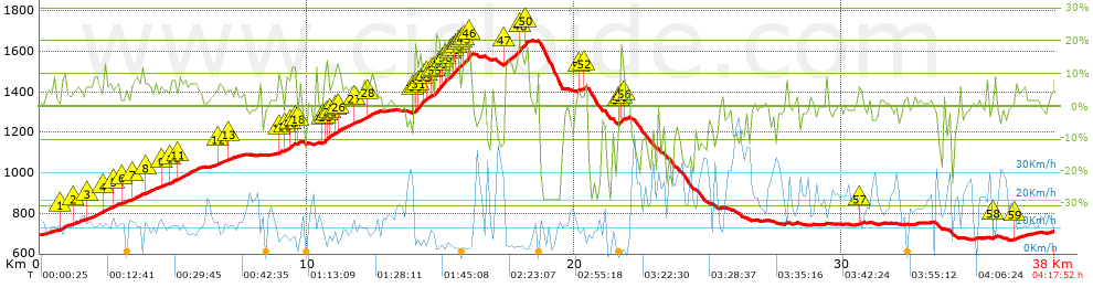
Distance in Km: 37.97
Climb in m: 1280
IBP: 105 BYC

Near ...
Atalaya, La, Burguillo, El, Cerro De Guisando, Cruceras, Las, Puente Nuevo, Rinconada Del Valle, La
Brujo1971
Author: Brujo1971
417 published routes

Add to my Group or Club

 Height in m      Climb in %      Speed in Km/h      Speed < 2 Km/h

Climbs > 5%

Climbs >5% Climbs >10% Climbs >15% Climbs >20% Climbs >25%
 Steep slope of 244 m.   Average slope  Distances  Download as waypoint
1
 Km 0.797  8%  244 m
 Steep slope of 240 m.  Average slope  Distances  Download as waypoint
2
 Km 1.316  6%  240 m
 Steep slope of 518 m.  Average slope  Distances  Download as waypoint
3
 Km 1.744  6%  518 m
 Steep slope of 234 m.  Average slope  Distances  Download as waypoint
4
 Km 2.403  7%  234 m
 Steep slope of 203 m.  Average slope  Distances  Download as waypoint
5
 Km 2.778  7%  203 m
 Steep slope of 218 m.  Average slope  Distances  Download as waypoint
6
 Km 3.085  5%  218 m
 Steep slope of 444 m.  Average slope  Distances  Download as waypoint
7
 Km 3.438  7%  444 m
 Steep slope of 303 m.  Average slope  Distances  Download as waypoint
8
 Km 3.986  6%  303 m
 Steep slope of 209 m.  Average slope  Distances  Download as waypoint
9
 Km 4.533  6%  209 m
 Steep slope of 172 m.  Average slope  Distances  Download as waypoint
10
 Km 4.884  8%  172 m
 Steep slope of 818 m.  Average slope  Distances  Download as waypoint
11
 Km 5.2  7%  818 m
 Steep slope of 245 m.  Average slope  Distances  Download as waypoint
12
 Km 6.665  7%  245 m
 Steep slope of 240 m.  Average slope  Distances  Download as waypoint
13
 Km 7.084  5%  240 m
 Steep slope of 134 m.  Average slope  Distances  Download as waypoint
14
 Km 8.918  9%  134 m
 Steep slope of 367 m.  Average slope  Distances  Download as waypoint
15
 Km 9.199  8%  165 m
16
 Km 9.364  10%  167 m
17
 Km 9.531  12%  35 m
 Steep slope of 102 m.  Average slope  Distances  Download as waypoint
18
 Km 9.666  12%  102 m
 Steep slope of 392 m.  Average slope  Distances  Download as waypoint
19
 Km 10.615  7%  67 m
20
 Km 10.682  11%  34 m
21
 Km 10.716  17%  93 m
22
 Km 10.809  10%  69 m
23
 Km 10.878  8%  129 m
 Steep slope of 593 m.  Average slope  Distances  Download as waypoint
24
 Km 11.04  7%  65 m
25
 Km 11.105  5%  34 m
26
 Km 11.139  8%  494 m
 Steep slope of 440 m.  Average slope  Distances  Download as waypoint
27
 Km 11.736  6%  440 m
 Steep slope of 307 m.  Average slope  Distances  Download as waypoint
28
 Km 12.277  8%  307 m
 Steep slope of 699 m.  Average slope  Distances  Download as waypoint
29
 Km 13.986  8%  33 m
30
 Km 14.019  16%  174 m
31
 Km 14.194  14%  219 m
32
 Km 14.413  11%  102 m
33
 Km 14.515  11%  136 m
34
 Km 14.651  8%  35 m
 Steep slope of 1375 m.  Average slope  Distances  Download as waypoint
35
 Km 14.8  19%  190 m
36
 Km 14.991  14%  96 m
37
 Km 15.086  19%  127 m
38
 Km 15.213  7%  131 m
39
 Km 15.345  14%  65 m
40
 Km 15.41  14%  93 m
41
 Km 15.502  15%  95 m
42
 Km 15.597  19%  99 m
43
 Km 15.696  7%  100 m
44
 Km 15.797  13%  65 m
45
 Km 15.861  16%  189 m
46
 Km 16.05  15%  125 m
 Steep slope of 867 m.  Average slope  Distances  Download as waypoint
47
 Km 17.411  13%  606 m
48
 Km 18.017  10%  132 m
49
 Km 18.149  13%  32 m
50
 Km 18.181  20%  97 m
 Steep slope of 103 m.  Average slope  Distances  Download as waypoint
51
 Km 20.133  6%  103 m
 Steep slope of 96 m.  Average slope  Distances  Download as waypoint
52
 Km 20.368  8%  96 m
 Steep slope of 252 m.  Average slope  Distances  Download as waypoint
53
 Km 21.671  9%  31 m
54
 Km 21.703  14%  32 m
55
 Km 21.735  18%  97 m
56
 Km 21.832  6%  92 m
 Steep slope of 179 m.  Average slope  Distances  Download as waypoint
57
 Km 30.628  6%  179 m
 Steep slope of 143 m.  Average slope  Distances  Download as waypoint
58
 Km 35.655  8%  143 m
 Steep slope of 146 m.  Average slope  Distances  Download as waypoint
59
 Km 36.501  6%  146 m


Description of the route


Presence of ramps


 Climbs  Distance  % of the total  Speed  Your speed would be  Time  Your time would be
   15 - 30%  1.404  3.7  4.37  ?  0:19:17  ?
   10 - 15%  2.231  5.88  5.19  ?  0:25:47  ?
   5 - 10%  7.579  19.96  10.05  ?  0:45:15  ?
   1 - 5%  8.11  21.36  12.41  ?  0:39:13  ?
   Total*  19.324 Km  50.89 %  8.95 Km/h  ? Km/h    2:09:32 h  ? h  
 Flat
   1 - -1%  5.394 Km  14.2 %  18 Km/h  ? Km/h    0:17:59 h  ? h  
 Descents
   -1 - -5%  5.385  14.18  18.8  ?  0:17:11  ?
   -5 - -10%  2.923  7.7  21.97  ?  0:07:59  ?
   -10 - -15%  1.826  4.81  18.21  ?  0:06:01  ?
   -15 - -30%  3.122  8.22  9.72  ?  0:19:16  ?
   Total*  13.256 Km  34.91 %  15.77 Km/h  ? Km/h    0:50:27 h  ? h  
* The total has not necessarily coincide with the sum of the partials after correction of errors

How long would it take you?

How long would it take you to cover this route?
There are routes without a valid time information, but with your average stats you can assess the possible duration

Brujo1971 to cover this route you've need a time of:   3:17:58 h 
If you sign in and have a minimum of two tracks of this same modality, you can know your time for this route, calculated from your stats..


¿Cuanto consumirá tu E-BIKE?

Entra tu E-IBP (formato n,nn)

E-IBP :   X 105 = 


 Detected activity type =  ()
 Penalization due to track conditions: 69 %   ( > 50 % = MTB, < 50 % = RDB)
 Reliability of the track: A   (1287/73/0/-/-/73)
 Correction level applied to the track: 0
DIFFICULTY OF THE ROUTE
IBP = 105 BYC
According to your statistics
 Your time in motion would be: ? h
Your average speed would be: ? Km/h
 

 Total Distance: 37.97 Km
 Analysed distance: 37.97 Km
 Linear distance: 0.08 Km

 Cumulated positive ramps: 1279.8 m  list of points info
 Cumulated negative ramps: 1260.74 m
 Maximum height: 1651.8 m
 Minimum height: 669.2 m
 Climbing Ratio: 6.62 %
 Descent ratio: 9.51 %
 Cumulated postive ramps per Km: 33.71 m
 Cumulated negative ramps per Km: 33.2 m

 Total time: 4:17:52 h
 Time in movement: 3:17:58 h
 According to your statistics
 Your time in motion would be: ? h  
 Stopped time: 0:59:54 h
 Maximum slope filter: ~30 %
 Minimum separation analysed: ~30 m
 Number of points: 2868   (cad. 13.24 m)
 Significant waypoints: 1057   (cad. 35.93 m / 36.85 %)

 Changes in direction per Km: 11.51
 Changes in direction > 5º por Km: 8.56
 Cumulated straight stretches: 5.266 Km
 Straight stretches per Km: 138.69 m
 Penalized slope changes: 12
 Penalized slope changes per Km: 0.316

 Average speed in total: 8.84 Km/h
 Average speed while moving: 11.51 Km/h
 According to your statistics
 Your average speed would be: ? Km/h  
 Maximum sustained speed: 51.44 Km/h


Comments

You can be the first one in commenting this route

 
My comments
:
Add comment  (Registered users)
 
Notify me answers to my comment  Do not notify answers to my comment


Share this route with a friend

Your friend will receive a message with a link to this page:
will see your email and your user name if you do it as registered user.


Write here your name (optional)

E-mail address of your friend(s). You can include various addresses separated by commas

Text or comment (optional) maximum 255 characters long, 255 Available characters

As a non registered users you need to fill-in the captcha text.
  Change image
Type the image characters.
 
 Share with a friend


Visited history

Delete history

Marked routes for review later or compare

My favorites


  Notify anomaly in this route Share in Facebook