CICLI ST ELIAS-EL POLELL-PLA DÉ LA CALMA -CANOVAS

MTB
MTB
Ref..: 1001157
Published: 11/10/2021
Performed: 11/10/2021
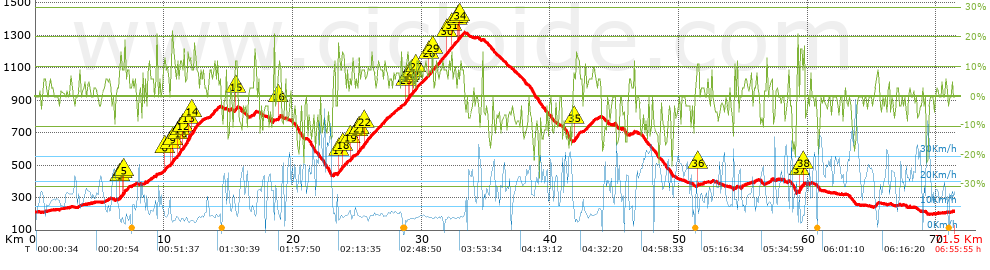
Distance in Km: 71.54
Climb in m: 2252
IBP: 168 BYC

Near ...
Batlloria, La (Sant Celoni), Sant Celoni, Santa Maria De Palautordera

 Height in m      Climb in %      Speed in Km/h      Speed < 2 Km/h

Climbs > 10%

Climbs >5% Climbs >10% Climbs >15% Climbs >20% Climbs >25%
 Steep slope of 326 m.   Average slope  Distances  Download as waypoint
1
 Km 6.608  10%  167 m
2
 Km 6.775  13%  32 m
3
 Km 6.807  13%  61 m
4
 Km 6.869  12%  33 m
5
 Km 6.901  17%  65 m
 Steep slope of 1540 m.  Average slope  Distances  Download as waypoint
6
 Km 10.039  13%  100 m
7
 Km 10.509  10%  132 m
8
 Km 10.641  21%  63 m
9
 Km 10.704  10%  30 m
10
 Km 11.095  15%  128 m
11
 Km 11.223  15%  65 m
12
 Km 11.452  13%  432 m
13
 Km 11.884  12%  291 m
14
 Km 12.175  14%  259 m
 Steep slope of 133 m.  Average slope  Distances  Download as waypoint
15
 Km 15.546  11%  133 m
 Steep slope of 100 m.  Average slope  Distances  Download as waypoint
16
 Km 18.864  10%  100 m
 Steep slope of 1881 m.  Average slope  Distances  Download as waypoint
17
 Km 23.522  13%  130 m
18
 Km 23.848  13%  137 m
19
 Km 24.49  12%  97 m
20
 Km 25.062  13%  95 m
21
 Km 25.157  10%  455 m
22
 Km 25.612  11%  228 m
23
 Km 28.789  12%  128 m
24
 Km 28.917  10%  163 m
25
 Km 29.08  12%  95 m
26
 Km 29.274  11%  167 m
27
 Km 29.575  11%  169 m
28
 Km 30.56  11%  99 m
29
 Km 30.831  10%  134 m
30
 Km 31.999  10%  101 m
31
 Km 32.33  12%  99 m
32
 Km 32.763  11%  103 m
33
 Km 32.866  10%  100 m
34
 Km 32.966  10%  99 m
 Steep slope of 456 m.  Average slope  Distances  Download as waypoint
35
 Km 41.905  12%  322 m
 Steep slope of 105 m.  Average slope  Distances  Download as waypoint
36
 Km 51.423  10%  105 m
 Steep slope of 391 m.  Average slope  Distances  Download as waypoint
37
 Km 59.371  18%  192 m
38
 Km 59.66  15%  102 m


Description of the route


Presence of ramps


 Climbs  Distance  % of the total  Speed  Your speed would be  Time  Your time would be
   15 - 30%  1.626  2.27  5.89  ?  0:16:34  ?
   10 - 15%  5.221  7.3  7.02  ?  0:44:37  ?
   5 - 10%  14.415  20.15  8.12  ?  1:46:30  ?
   1 - 5%  8.26  11.55  11.53  ?  0:43:00  ?
   Total*  29.521 Km  41.27 %  8.41 Km/h  ? Km/h    3:30:41 h  ? h  
 Flat
   1 - -1%  13.671 Km  19.11 %  16.04 Km/h  ? Km/h    0:51:09 h  ? h  
 Descents
   -1 - -5%  9.324  13.03  19.66  ?  0:28:27  ?
   -5 - -10%  10.641  14.87  20.08  ?  0:31:48  ?
   -10 - -15%  5.729  8.01  22.69  ?  0:15:09  ?
   -15 - -30%  2.652  3.71  23.75  ?  0:06:42  ?
   Total*  28.346 Km  39.62 %  20.72 Km/h  ? Km/h    1:22:06 h  ? h  
* The total has not necessarily coincide with the sum of the partials after correction of errors

How long would it take you?

How long would it take you to cover this route?
There are routes without a valid time information, but with your average stats you can assess the possible duration

Kiko_Vitamina__B_&_G to cover this route you've need a time of:   5:43:56 h 
If you sign in and have a minimum of two tracks of this same modality, you can know your time for this route, calculated from your stats..


¿Cuanto consumirá tu E-BIKE?

Entra tu E-IBP (formato n,nn)

E-IBP :   X 168 = 


 Detected activity type =  ()
 Penalization due to track conditions: 72 %   ( > 50 % = MTB, < 50 % = RDB)
 Reliability of the track: A   (2254/77/0/-/-/77)
 Correction level applied to the track: 0
DIFFICULTY OF THE ROUTE
IBP = 168 BYC
According to your statistics
 Your time in motion would be: ? h
Your average speed would be: ? Km/h
 

 Total Distance: 71.54 Km
 Analysed distance: 71.54 Km
 Linear distance: 0.21 Km

 Cumulated positive ramps: 2251.6 m  list of points info
 Cumulated negative ramps: 2248.6 m
 Maximum height: 1314.9 m
 Minimum height: 196.9 m
 Climbing Ratio: 7.63 %
 Descent ratio: 7.93 %
 Cumulated postive ramps per Km: 31.47 m
 Cumulated negative ramps per Km: 31.43 m

 Total time: 6:55:55 h
 Time in movement: 5:43:56 h
 According to your statistics
 Your time in motion would be: ? h  
 Stopped time: 1:11:59 h
 Maximum slope filter: ~30 %
 Minimum separation analysed: ~30 m
 Number of points: 5757   (cad. 12.43 m)
 Significant waypoints: 2028   (cad. 35.28 m / 35.23 %)

 Changes in direction per Km: 11.31
 Changes in direction > 5º por Km: 8.07
 Cumulated straight stretches: 12.025 Km
 Straight stretches per Km: 168.09 m
 Penalized slope changes: 15
 Penalized slope changes per Km: 0.21

 Average speed in total: 10.32 Km/h
 Average speed while moving: 12.48 Km/h
 According to your statistics
 Your average speed would be: ? Km/h  
 Maximum sustained speed: 54.35 Km/h


Comments

You can be the first one in commenting this route

 
My comments
:
Add comment  (Registered users)
 
Notify me answers to my comment  Do not notify answers to my comment


Share this route with a friend

Your friend will receive a message with a link to this page:
will see your email and your user name if you do it as registered user.


Write here your name (optional)

E-mail address of your friend(s). You can include various addresses separated by commas

Text or comment (optional) maximum 255 characters long, 255 Available characters

As a non registered users you need to fill-in the captcha text.
  Change image
Type the image characters.
 
 Share with a friend


Visited history

Delete history

Marked routes for review later or compare

My favorites


  Notify anomaly in this route Share in Facebook