Bomberos

MTB
MTB
Ref..: 999614
Published: 05/10/2021
Performed: 04/10/2021
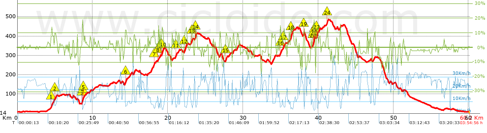
Distance in Km: 60.19
Climb in m: 1373
IBP: 104 BYC

Near ...
Aroles, Bandin, Baragaña (Carreño), Barquera, La (Carreño), Barreres (Albandi_Carreño), Barreres (Pervera-Carreño)

 Height in m      Climb in %      Speed in Km/h      Speed < 2 Km/h

Climbs > 10%

Climbs >5% Climbs >10% Climbs >15% Climbs >20% Climbs >25%
 Steep slope of 242 m.   Average slope  Distances  Download as waypoint
1
 Km 4.503  12%  137 m
2
 Km 4.946  10%  105 m
 Steep slope of 223 m.  Average slope  Distances  Download as waypoint
3
 Km 8.584  12%  64 m
4
 Km 8.648  19%  95 m
5
 Km 8.744  12%  64 m
 Steep slope of 174 m.  Average slope  Distances  Download as waypoint
6
 Km 14.332  11%  174 m
 Steep slope of 94 m.  Average slope  Distances  Download as waypoint
7
 Km 18.13  14%  94 m
 Steep slope of 98 m.  Average slope  Distances  Download as waypoint
8
 Km 18.71  15%  98 m
 Steep slope of 98 m.  Average slope  Distances  Download as waypoint
9
 Km 18.945  13%  98 m
 Steep slope of 228 m.  Average slope  Distances  Download as waypoint
10
 Km 19.153  13%  228 m
 Steep slope of 129 m.  Average slope  Distances  Download as waypoint
11
 Km 21.028  12%  129 m
 Steep slope of 295 m.  Average slope  Distances  Download as waypoint
12
 Km 22.204  12%  295 m
 Steep slope of 130 m.  Average slope  Distances  Download as waypoint
13
 Km 23.135  13%  130 m
 Steep slope of 133 m.  Average slope  Distances  Download as waypoint
14
 Km 23.623  14%  133 m
 Steep slope of 99 m.  Average slope  Distances  Download as waypoint
15
 Km 27.685  11%  99 m
 Steep slope of 231 m.  Average slope  Distances  Download as waypoint
16
 Km 34.949  12%  99 m
17
 Km 35.414  10%  132 m
 Steep slope of 294 m.  Average slope  Distances  Download as waypoint
18
 Km 36.318  13%  294 m
 Steep slope of 99 m.  Average slope  Distances  Download as waypoint
19
 Km 38.056  14%  99 m
 Steep slope of 292 m.  Average slope  Distances  Download as waypoint
20
 Km 39.253  11%  162 m
21
 Km 39.416  20%  97 m
22
 Km 39.512  20%  33 m
 Steep slope of 223 m.  Average slope  Distances  Download as waypoint
23
 Km 39.755  13%  223 m
 Steep slope of 169 m.  Average slope  Distances  Download as waypoint
24
 Km 41.156  13%  169 m


Description of the route


Presence of ramps


 Climbs  Distance  % of the total  Speed  Your speed would be  Time  Your time would be
   15 - 30%  0.581  0.96  5.4  ?  0:06:27  ?
   10 - 15%  3.45  5.73  7.08  ?  0:29:14  ?
   5 - 10%  7.377  12.26  10.6  ?  0:41:45  ?
   1 - 5%  11.725  19.48  15.57  ?  0:45:11  ?
   Total*  23.132 Km  38.43 %  11.32 Km/h  ? Km/h    2:02:37 h  ? h  
 Flat
   1 - -1%  12.369 Km  20.55 %  21.59 Km/h  ? Km/h    0:34:22 h  ? h  
 Descents
   -1 - -5%  13.852  23.01  25.47  ?  0:32:38  ?
   -5 - -10%  6.211  10.32  28.16  ?  0:13:14  ?
   -10 - -15%  4.093  6.8  32.03  ?  0:07:40  ?
   -15 - -30%  0.536  0.89  25.41  ?  0:01:16  ?
   Total*  24.692 Km  41.02 %  27.03 Km/h  ? Km/h    0:54:48 h  ? h  
* The total has not necessarily coincide with the sum of the partials after correction of errors

How long would it take you?

How long would it take you to cover this route?
There are routes without a valid time information, but with your average stats you can assess the possible duration

Manuel_Sanchez_Huerta to cover this route you've need a time of:   3:31:47 h 
If you sign in and have a minimum of two tracks of this same modality, you can know your time for this route, calculated from your stats..


¿Cuanto consumirá tu E-BIKE?

Entra tu E-IBP (formato n,nn)

E-IBP :   X 104 = 


 Detected activity type =  ()
 Penalization due to track conditions: 68 %   ( > 50 % = MTB, < 50 % = RDB)
 Reliability of the track: C   (1373/57/0/-/-/57)
 Correction level applied to the track: 0
DIFFICULTY OF THE ROUTE
IBP = 104 BYC
According to your statistics
 Your time in motion would be: ? h
Your average speed would be: ? Km/h
 

 Total Distance: 60.19 Km
 Analysed distance: 60.19 Km
 Linear distance: 0.13 Km

 Cumulated positive ramps: 1373.1 m  list of points info
 Cumulated negative ramps: 1360.7 m
 Maximum height: 485.4 m
 Minimum height: 6.9 m
 Climbing Ratio: 5.94 %
 Descent ratio: 5.51 %
 Cumulated postive ramps per Km: 22.81 m
 Cumulated negative ramps per Km: 22.61 m

 Total time: 3:54:56 h
 Time in movement: 3:31:47 h
 According to your statistics
 Your time in motion would be: ? h  
 Stopped time: 0:23:09 h
 Maximum slope filter: ~30 %
 Minimum separation analysed: ~30 m
 Number of points: 4603   (cad. 13.08 m)
 Significant waypoints: 1703   (cad. 35.35 m / 37 %)

 Changes in direction per Km: 10.32
 Changes in direction > 5º por Km: 6.89
 Cumulated straight stretches: 13.814 Km
 Straight stretches per Km: 229.51 m
 Penalized slope changes: 15
 Penalized slope changes per Km: 0.249

 Average speed in total: 15.37 Km/h
 Average speed while moving: 17.05 Km/h
 According to your statistics
 Your average speed would be: ? Km/h  
 Maximum sustained speed: 52.26 Km/h


Comments

You can be the first one in commenting this route

 
My comments
:
Add comment  (Registered users)
 
Notify me answers to my comment  Do not notify answers to my comment


Share this route with a friend

Your friend will receive a message with a link to this page:
will see your email and your user name if you do it as registered user.


Write here your name (optional)

E-mail address of your friend(s). You can include various addresses separated by commas

Text or comment (optional) maximum 255 characters long, 255 Available characters

As a non registered users you need to fill-in the captcha text.
  Change image
Type the image characters.
 
 Share with a friend


Visited history

Delete history

Marked routes for review later or compare

My favorites


  Notify anomaly in this route Share in Facebook