Sanata, Palautordera, Refugis de Montseny y Sant Celoni

MTB
MTB
Ref..: 973718
Published: 28/06/2021
Performed: 27/06/2021
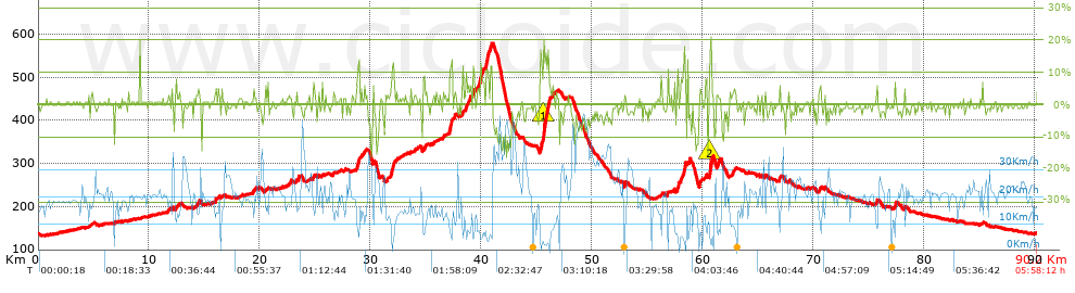
Distance in Km: 90.24
Climb in m: 1159
IBP: 104 BYC

Near ...
Conreria, La (Sant Fost Campcentelles), Gallecs, Martorelles, Mollet Del Valles, Montmelo, Sant Fost De Campsentelles

 Height in m      Climb in %      Speed in Km/h      Speed < 2 Km/h

Climbs > 5%

Climbs >5% Climbs >10% Climbs >15% Climbs >20% Climbs >25%
 Steep slope of 158 m.   Average slope  Distances  Download as waypoint
1
 Km 15.954  5%  158 m
 Steep slope of 277 m.  Average slope  Distances  Download as waypoint
2
 Km 28.739  8%  76 m
3
 Km 28.816  10%  162 m
4
 Km 28.978  12%  39 m
 Steep slope of 119 m.  Average slope  Distances  Download as waypoint
5
 Km 29.409  6%  119 m
 Steep slope of 258 m.  Average slope  Distances  Download as waypoint
6
 Km 31.912  13%  189 m
7
 Km 32.101  7%  69 m
 Steep slope of 164 m.  Average slope  Distances  Download as waypoint
8
 Km 34.737  5%  164 m
 Steep slope of 309 m.  Average slope  Distances  Download as waypoint
9
 Km 37.093  7%  31 m
10
 Km 37.123  12%  240 m
11
 Km 37.363  12%  38 m
 Steep slope of 210 m.  Average slope  Distances  Download as waypoint
12
 Km 38.585  7%  210 m
 Steep slope of 110 m.  Average slope  Distances  Download as waypoint
13
 Km 38.978  8%  110 m
 Steep slope of 180 m.  Average slope  Distances  Download as waypoint
14
 Km 39.246  7%  180 m
 Steep slope of 458 m.  Average slope  Distances  Download as waypoint
15
 Km 39.631  6%  277 m
16
 Km 39.907  13%  104 m
17
 Km 40.012  8%  77 m
 Steep slope of 281 m.  Average slope  Distances  Download as waypoint
18
 Km 40.361  12%  281 m
 Steep slope of 235 m.  Average slope  Distances  Download as waypoint
19
 Km 40.685  6%  72 m
20
 Km 40.756  7%  163 m
 Steep slope of 912 m.  Average slope  Distances  Download as waypoint
21
 Km 45.32  12%  232 m
22
 Km 45.552  18%  264 m
23
 Km 45.816  15%  75 m
24
 Km 45.891  10%  114 m
25
 Km 46.005  14%  139 m
26
 Km 46.144  7%  88 m
 Steep slope of 165 m.  Average slope  Distances  Download as waypoint
27
 Km 57.684  10%  129 m
28
 Km 57.813  20%  36 m
 Steep slope of 366 m.  Average slope  Distances  Download as waypoint
29
 Km 57.992  6%  249 m
30
 Km 58.241  15%  117 m
 Steep slope of 118 m.  Average slope  Distances  Download as waypoint
31
 Km 58.61  9%  118 m
 Steep slope of 336 m.  Average slope  Distances  Download as waypoint
32
 Km 60.561  6%  30 m
33
 Km 60.591  17%  175 m
34
 Km 60.767  18%  40 m
35
 Km 60.807  9%  91 m
 Steep slope of 125 m.  Average slope  Distances  Download as waypoint
36
 Km 61.271  8%  125 m
 Steep slope of 140 m.  Average slope  Distances  Download as waypoint
37
 Km 66.854  8%  140 m
 Steep slope of 101 m.  Average slope  Distances  Download as waypoint
38
 Km 75.685  8%  101 m
 Steep slope of 120 m.  Average slope  Distances  Download as waypoint
39
 Km 77.312  11%  120 m


Description of the route


Presence of ramps


 Climbs  Distance  % of the total  Speed  Your speed would be  Time  Your time would be
   15 - 30%  0.883  0.98  4.08  ?  0:13:00  ?
   10 - 15%  2.179  2.41  5.24  ?  0:24:58  ?
   5 - 10%  4.439  4.92  9.01  ?  0:29:33  ?
   1 - 5%  17.615  19.52  14.41  ?  1:13:22  ?
   Total*  25.117 Km  27.83 %  10.7 Km/h  ? Km/h    2:20:53 h  ? h  
 Flat
   1 - -1%  38.134 Km  42.26 %  20.3 Km/h  ? Km/h    1:52:42 h  ? h  
 Descents
   -1 - -5%  19.233  21.31  23  ?  0:50:10  ?
   -5 - -10%  5.259  5.83  26.04  ?  0:12:07  ?
   -10 - -15%  1.94  2.15  13.97  ?  0:08:20  ?
   -15 - -30%  0.557  0.62  22.26  ?  0:01:30  ?
   Total*  26.989 Km  29.91 %  22.45 Km/h  ? Km/h    1:12:07 h  ? h  
* The total has not necessarily coincide with the sum of the partials after correction of errors

How long would it take you?

How long would it take you to cover this route?
There are routes without a valid time information, but with your average stats you can assess the possible duration

Eloy Martinez Hortelano to cover this route you've need a time of:   5:25:42 h 
If you sign in and have a minimum of two tracks of this same modality, you can know your time for this route, calculated from your stats..


¿Cuanto consumirá tu E-BIKE?

Entra tu E-IBP (formato n,nn)

E-IBP :   X 104 = 


 Detected activity type =  ()
 Penalization due to track conditions: 52 %   ( > 50 % = MTB, < 50 % = RDB)
 Reliability of the track: C   (1170/54/0/-/-/54)
 Correction level applied to the track: 0
DIFFICULTY OF THE ROUTE
IBP = 104 BYC
According to your statistics
 Your time in motion would be: ? h
Your average speed would be: ? Km/h
 

 Total Distance: 90.24 Km
 Analysed distance: 90.24 Km
 Linear distance: 0.08 Km

 Cumulated positive ramps: 1158.64 m  list of points info
 Cumulated negative ramps: 1160.84 m
 Maximum height: 579.2 m
 Minimum height: 132.6 m
 Climbing Ratio: 4.61 %
 Descent ratio: 4.3 %
 Cumulated postive ramps per Km: 12.84 m
 Cumulated negative ramps per Km: 12.86 m

 Total time: 5:58:12 h
 Time in movement: 5:25:42 h
 According to your statistics
 Your time in motion would be: ? h  
 Stopped time: 0:32:30 h
 Maximum slope filter: ~30 %
 Minimum separation analysed: ~30 m
 Number of points: 3361   (cad. 26.85 m)
 Significant waypoints: 1913   (cad. 47.17 m / 56.92 %)

 Changes in direction per Km: 8.88
 Changes in direction > 5º por Km: 5.51
 Cumulated straight stretches: 25.917 Km
 Straight stretches per Km: 287.2 m
 Penalized slope changes: 10
 Penalized slope changes per Km: 0.111

 Average speed in total: 15.12 Km/h
 Average speed while moving: 16.62 Km/h
 According to your statistics
 Your average speed would be: ? Km/h  
 Maximum sustained speed: 52.22 Km/h


Comments

You can be the first one in commenting this route

 
My comments
:
Add comment  (Registered users)
 
Notify me answers to my comment  Do not notify answers to my comment


Share this route with a friend

Your friend will receive a message with a link to this page:
will see your email and your user name if you do it as registered user.


Write here your name (optional)

E-mail address of your friend(s). You can include various addresses separated by commas

Text or comment (optional) maximum 255 characters long, 255 Available characters

As a non registered users you need to fill-in the captcha text.
  Change image
Type the image characters.
 
 Share with a friend


Visited history

Delete history

Marked routes for review later or compare

My favorites


  Notify anomaly in this route Share in Facebook