Pamplona - Esquiroz - Beriain - Campanas - Biurrun - Subiza - Arlegui - Pamplona

MTB
MTB
Ref..: 961869
Published: 16/05/2021
Performed: 15/05/2021
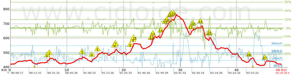
Distance in Km: 47.97
Climb in m: 819
IBP: 53 BYC

delfinpos
Author: delfinpos
357 published routes

Add to my Group or Club

 Height in m      Climb in %      Speed in Km/h      Speed < 2 Km/h

Climbs > 5%

Climbs >5% Climbs >10% Climbs >15% Climbs >20% Climbs >25%
 Steep slope of 216 m.   Average slope  Distances  Download as waypoint
1
 Km 6.429  8%  216 m
 Steep slope of 104 m.  Average slope  Distances  Download as waypoint
2
 Km 6.825  11%  104 m
 Steep slope of 119 m.  Average slope  Distances  Download as waypoint
3
 Km 12.658  11%  119 m
 Steep slope of 202 m.  Average slope  Distances  Download as waypoint
4
 Km 14.394  7%  202 m
 Steep slope of 148 m.  Average slope  Distances  Download as waypoint
5
 Km 15.405  7%  148 m
 Steep slope of 143 m.  Average slope  Distances  Download as waypoint
6
 Km 18.367  6%  143 m
 Steep slope of 105 m.  Average slope  Distances  Download as waypoint
7
 Km 18.617  7%  105 m
 Steep slope of 627 m.  Average slope  Distances  Download as waypoint
8
 Km 21.204  8%  453 m
9
 Km 21.657  12%  105 m
10
 Km 21.762  7%  69 m
 Steep slope of 590 m.  Average slope  Distances  Download as waypoint
11
 Km 24.847  8%  104 m
12
 Km 24.951  11%  203 m
13
 Km 25.154  8%  283 m
 Steep slope of 733 m.  Average slope  Distances  Download as waypoint
14
 Km 26.522  8%  733 m
 Steep slope of 138 m.  Average slope  Distances  Download as waypoint
15
 Km 27.364  5%  138 m
 Steep slope of 361 m.  Average slope  Distances  Download as waypoint
16
 Km 27.685  7%  361 m
 Steep slope of 104 m.  Average slope  Distances  Download as waypoint
17
 Km 28.194  11%  104 m
 Steep slope of 165 m.  Average slope  Distances  Download as waypoint
18
 Km 28.416  11%  100 m
19
 Km 28.516  10%  65 m
 Steep slope of 383 m.  Average slope  Distances  Download as waypoint
20
 Km 28.892  8%  383 m
 Steep slope of 291 m.  Average slope  Distances  Download as waypoint
21
 Km 31.824  9%  291 m
 Steep slope of 135 m.  Average slope  Distances  Download as waypoint
22
 Km 32.285  7%  135 m
 Steep slope of 259 m.  Average slope  Distances  Download as waypoint
23
 Km 33.554  6%  259 m
 Steep slope of 204 m.  Average slope  Distances  Download as waypoint
24
 Km 35.095  7%  104 m
25
 Km 35.199  14%  100 m
 Steep slope of 210 m.  Average slope  Distances  Download as waypoint
26
 Km 42.169  6%  210 m
 Steep slope of 250 m.  Average slope  Distances  Download as waypoint
27
 Km 44.964  8%  250 m


Description of the route


Presence of ramps


 Climbs  Distance  % of the total  Speed  Your speed would be  Time  Your time would be
   15 - 30%  0.101  0.21  6.27  ?  0:00:58  ?
   10 - 15%  1.011  2.11  7.37  ?  0:08:14  ?
   5 - 10%  5.022  10.47  8.54  ?  0:35:17  ?
   1 - 5%  12.779  26.64  12.64  ?  1:00:40  ?
   Total*  18.914 Km  39.42 %  10.79 Km/h  ? Km/h    1:45:09 h  ? h  
 Flat
   1 - -1%  11.609 Km  24.2 %  15.07 Km/h  ? Km/h    0:46:13 h  ? h  
 Descents
   -1 - -5%  10.846  22.61  18.25  ?  0:35:39  ?
   -5 - -10%  5.499  11.46  20.73  ?  0:15:55  ?
   -10 - -15%  0.813  1.69  20.32  ?  0:02:24  ?
   -15 - -30%  0.294  0.61  12.43  ?  0:01:25  ?
   Total*  17.452 Km  36.38 %  18.91 Km/h  ? Km/h    0:55:23 h  ? h  
* The total has not necessarily coincide with the sum of the partials after correction of errors

How long would it take you?

How long would it take you to cover this route?
There are routes without a valid time information, but with your average stats you can assess the possible duration

delfinpos to cover this route you've need a time of:   3:26:45 h 
If you sign in and have a minimum of two tracks of this same modality, you can know your time for this route, calculated from your stats..


¿Cuanto consumirá tu E-BIKE?

Entra tu E-IBP (formato n,nn)

E-IBP :   X 53 = 


 Detected activity type =  ()
 Penalization due to track conditions: 58 %   ( > 50 % = MTB, < 50 % = RDB)
 Reliability of the track: C   (819/56/0/-/-/56)
 Correction level applied to the track: 0
DIFFICULTY OF THE ROUTE
IBP = 53 BYC
According to your statistics
 Your time in motion would be: ? h
Your average speed would be: ? Km/h
 

 Total Distance: 47.97 Km
 Analysed distance: 47.97 Km
 Linear distance: 0.01 Km

 Cumulated positive ramps: 819.1 m  list of points info
 Cumulated negative ramps: 820.8 m
 Maximum height: 763.1 m
 Minimum height: 412.3 m
 Climbing Ratio: 4.33 %
 Descent ratio: 4.7 %
 Cumulated postive ramps per Km: 17.08 m
 Cumulated negative ramps per Km: 17.11 m

 Total time: 4:18:30 h
 Time in movement: 3:26:45 h
 According to your statistics
 Your time in motion would be: ? h  
 Stopped time: 0:51:45 h
 Maximum slope filter: ~30 %
 Minimum separation analysed: ~30 m
 Number of points: 3574   (cad. 13.42 m)
 Significant waypoints: 1311   (cad. 36.59 m / 36.68 %)

 Changes in direction per Km: 11.97
 Changes in direction > 5º por Km: 6.78
 Cumulated straight stretches: 12.38 Km
 Straight stretches per Km: 258.08 m
 Penalized slope changes: 7
 Penalized slope changes per Km: 0.146

 Average speed in total: 11.14 Km/h
 Average speed while moving: 13.92 Km/h
 According to your statistics
 Your average speed would be: ? Km/h  
 Maximum sustained speed: 50.33 Km/h


Comments

You can be the first one in commenting this route

 
My comments
:
Add comment  (Registered users)
 
Notify me answers to my comment  Do not notify answers to my comment


Share this route with a friend

Your friend will receive a message with a link to this page:
will see your email and your user name if you do it as registered user.


Write here your name (optional)

E-mail address of your friend(s). You can include various addresses separated by commas

Text or comment (optional) maximum 255 characters long, 255 Available characters

As a non registered users you need to fill-in the captcha text.
  Change image
Type the image characters.
 
 Share with a friend


Visited history

Delete history

Marked routes for review later or compare

My favorites


  Notify anomaly in this route Share in Facebook