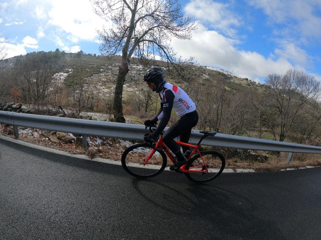
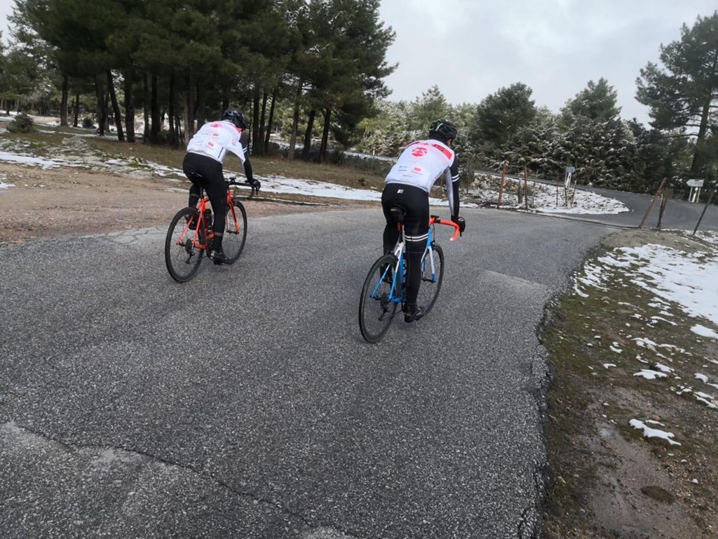
Rutón con el Team

Road
Road
Ref..: 939538
Published: 23/02/2021
Performed: 22/02/2021
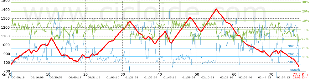
Distance in Km: 77.53
Climb in m: 1742
IBP: 91 BYC

Autor 30743
Author: Autor 30743
553 published routes

Add to my Group or Club

 Height in m      Climb in %      Speed in Km/h      Speed < 2 Km/h

Climbs > 5%

Climbs >5% Climbs >10% Climbs >15% Climbs >20% Climbs >25%
 Steep slope of 189 m.   Average slope  Distances  Download as waypoint
1
 Km 0.185  6%  189 m
 Steep slope of 421 m.  Average slope  Distances  Download as waypoint
2
 Km 0.566  6%  421 m
 Steep slope of 142 m.  Average slope  Distances  Download as waypoint
3
 Km 1.147  7%  142 m
 Steep slope of 113 m.  Average slope  Distances  Download as waypoint
4
 Km 1.987  7%  113 m
 Steep slope of 112 m.  Average slope  Distances  Download as waypoint
5
 Km 2.272  6%  112 m
 Steep slope of 161 m.  Average slope  Distances  Download as waypoint
6
 Km 4.244  6%  161 m
 Steep slope of 363 m.  Average slope  Distances  Download as waypoint
7
 Km 5.551  6%  363 m
 Steep slope of 819 m.  Average slope  Distances  Download as waypoint
8
 Km 6.937  6%  819 m
 Steep slope of 1041 m.  Average slope  Distances  Download as waypoint
9
 Km 9.765  8%  1041 m
 Steep slope of 403 m.  Average slope  Distances  Download as waypoint
10
 Km 17.937  8%  403 m
 Steep slope of 405 m.  Average slope  Distances  Download as waypoint
11
 Km 18.642  6%  405 m
 Steep slope of 331 m.  Average slope  Distances  Download as waypoint
12
 Km 21.084  6%  331 m
 Steep slope of 239 m.  Average slope  Distances  Download as waypoint
13
 Km 21.56  5%  239 m
 Steep slope of 217 m.  Average slope  Distances  Download as waypoint
14
 Km 23.17  5%  217 m
 Steep slope of 148 m.  Average slope  Distances  Download as waypoint
15
 Km 23.501  5%  148 m
 Steep slope of 318 m.  Average slope  Distances  Download as waypoint
16
 Km 24.345  6%  318 m
 Steep slope of 119 m.  Average slope  Distances  Download as waypoint
17
 Km 25.19  6%  119 m
 Steep slope of 156 m.  Average slope  Distances  Download as waypoint
18
 Km 25.473  6%  156 m
 Steep slope of 506 m.  Average slope  Distances  Download as waypoint
19
 Km 27.64  7%  506 m
 Steep slope of 305 m.  Average slope  Distances  Download as waypoint
20
 Km 28.729  6%  305 m
 Steep slope of 278 m.  Average slope  Distances  Download as waypoint
21
 Km 29.863  6%  278 m
 Steep slope of 103 m.  Average slope  Distances  Download as waypoint
22
 Km 30.567  6%  103 m
 Steep slope of 292 m.  Average slope  Distances  Download as waypoint
23
 Km 30.763  6%  292 m
 Steep slope of 402 m.  Average slope  Distances  Download as waypoint
24
 Km 31.16  7%  402 m
 Steep slope of 780 m.  Average slope  Distances  Download as waypoint
25
 Km 38.921  6%  780 m
 Steep slope of 105 m.  Average slope  Distances  Download as waypoint
26
 Km 40.218  5%  105 m
 Steep slope of 477 m.  Average slope  Distances  Download as waypoint
27
 Km 40.803  6%  477 m
 Steep slope of 307 m.  Average slope  Distances  Download as waypoint
28
 Km 43.201  8%  307 m
 Steep slope of 317 m.  Average slope  Distances  Download as waypoint
29
 Km 43.656  7%  317 m
 Steep slope of 295 m.  Average slope  Distances  Download as waypoint
30
 Km 44.153  6%  295 m
 Steep slope of 410 m.  Average slope  Distances  Download as waypoint
31
 Km 44.562  6%  410 m
 Steep slope of 252 m.  Average slope  Distances  Download as waypoint
32
 Km 45.15  7%  252 m
 Steep slope of 212 m.  Average slope  Distances  Download as waypoint
33
 Km 45.672  7%  212 m
 Steep slope of 558 m.  Average slope  Distances  Download as waypoint
34
 Km 46.067  6%  558 m
 Steep slope of 261 m.  Average slope  Distances  Download as waypoint
35
 Km 46.739  6%  261 m
 Steep slope of 180 m.  Average slope  Distances  Download as waypoint
36
 Km 47.117  5%  180 m
 Steep slope of 253 m.  Average slope  Distances  Download as waypoint
37
 Km 47.403  7%  253 m
 Steep slope of 241 m.  Average slope  Distances  Download as waypoint
38
 Km 47.85  6%  241 m
 Steep slope of 370 m.  Average slope  Distances  Download as waypoint
39
 Km 51.31  6%  370 m
 Steep slope of 447 m.  Average slope  Distances  Download as waypoint
40
 Km 51.783  7%  447 m
 Steep slope of 1619 m.  Average slope  Distances  Download as waypoint
41
 Km 52.38  7%  1619 m
 Steep slope of 404 m.  Average slope  Distances  Download as waypoint
42
 Km 54.109  6%  404 m
 Steep slope of 507 m.  Average slope  Distances  Download as waypoint
43
 Km 54.628  7%  507 m
 Steep slope of 631 m.  Average slope  Distances  Download as waypoint
44
 Km 69.649  6%  631 m
 Steep slope of 499 m.  Average slope  Distances  Download as waypoint
45
 Km 71.914  7%  499 m


Description of the route


Presence of ramps


 Climbs  Distance  % of the total  Speed  Your speed would be  Time  Your time would be
   15 - 30%  0  0  0  ?  0:00:00  ?
   10 - 15%  0.32  0.41  13.39  ?  0:01:26  ?
   5 - 10%  17.836  23.01  15.77  ?  1:07:52  ?
   1 - 5%  16.494  21.27  20.34  ?  0:48:39  ?
   Total*  34.65 Km  44.69 %  17.63 Km/h  ? Km/h    1:57:57 h  ? h  
 Flat
   1 - -1%  7.834 Km  10.1 %  29.5 Km/h  ? Km/h    0:15:56 h  ? h  
 Descents
   -1 - -5%  18.201  23.48  40.4  ?  0:27:02  ?
   -5 - -10%  15.25  19.67  50  ?  0:18:18  ?
   -10 - -15%  1.558  2.01  38.95  ?  0:02:24  ?
   -15 - -30%  0.036  0.05  14.6  ?  0:00:09  ?
   Total*  35.046 Km  45.2 %  43.91 Km/h  ? Km/h    0:47:53 h  ? h  
* The total has not necessarily coincide with the sum of the partials after correction of errors

How long would it take you?

How long would it take you to cover this route?
There are routes without a valid time information, but with your average stats you can assess the possible duration

Autor 30743 to cover this route you've need a time of:   3:01:46 h 
If you sign in and have a minimum of two tracks of this same modality, you can know your time for this route, calculated from your stats..


¿Cuanto consumirá tu E-BIKE?

Entra tu E-IBP (formato n,nn)

E-IBP :   X 91 = 


 Detected activity type =  ()
 Penalization due to track conditions: 35 %   ( > 50 % = MTB, < 50 % = RDB)
 Reliability of the track: A   (1742/91/0/-/-/91)
 Correction level applied to the track: 0
DIFFICULTY OF THE ROUTE
IBP = 91 BYC
According to your statistics
 Your time in motion would be: ? h
Your average speed would be: ? Km/h
 

 Total Distance: 77.53 Km
 Analysed distance: 77.53 Km
 Linear distance: 0.29 Km

 Cumulated positive ramps: 1742 m  list of points info
 Cumulated negative ramps: 1762.4 m
 Maximum height: 1409.6 m
 Minimum height: 753.6 m
 Climbing Ratio: 5.03 %
 Descent ratio: 5.03 %
 Cumulated postive ramps per Km: 22.47 m
 Cumulated negative ramps per Km: 22.73 m

 Total time: 3:03:53 h
 Time in movement: 3:01:46 h
 According to your statistics
 Your time in motion would be: ? h  
 Stopped time: 0:02:07 h
 Maximum slope filter: ~30 %
 Minimum separation analysed: ~30 m
 Number of points: 5732   (cad. 13.53 m)
 Significant waypoints: 2166   (cad. 35.79 m / 37.79 %)

 Changes in direction per Km: 7.58
 Changes in direction > 5º por Km: 3.84
 Cumulated straight stretches: 30.191 Km
 Straight stretches per Km: 389.41 m
 Penalized slope changes: 15
 Penalized slope changes per Km: 0.193

 Average speed in total: 25.3 Km/h
 Average speed while moving: 25.59 Km/h
 According to your statistics
 Your average speed would be: ? Km/h  
 Maximum sustained speed: 70.69 Km/h


Comments

You can be the first one in commenting this route

 
My comments
:
Add comment  (Registered users)
 
Notify me answers to my comment  Do not notify answers to my comment


Share this route with a friend

Your friend will receive a message with a link to this page:
will see your email and your user name if you do it as registered user.


Write here your name (optional)

E-mail address of your friend(s). You can include various addresses separated by commas

Text or comment (optional) maximum 255 characters long, 255 Available characters

As a non registered users you need to fill-in the captcha text.
  Change image
Type the image characters.
 
 Share with a friend


Visited history

Delete history

Marked routes for review later or compare

My favorites


  Notify anomaly in this route Share in Facebook