SR. Sierra Morena-Las Villas

Road
Road
Ref..: 864797
Published: 24/03/2020
Performed: 24/03/2020
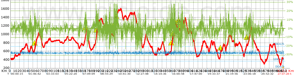
Distance in Km: 612.11
Climb in m: 14967
IBP: 1099 BYC

ercapi
Author: ercapi
749 published routes

Add to my Group or Club

 Height in m      Climb in %      Speed in Km/h      Speed < 2 Km/h

Climbs > 10%

Climbs >5% Climbs >10% Climbs >15% Climbs >20% Climbs >25%
 Steep slope of 223 m.   Average slope  Distances  Download as waypoint
1
 Km 44.594  12%  191 m
 Steep slope of 115 m.  Average slope  Distances  Download as waypoint
2
 Km 53.915  17%  115 m
 Steep slope of 642 m.  Average slope  Distances  Download as waypoint
3
 Km 57.851  13%  199 m
 Steep slope of 464 m.  Average slope  Distances  Download as waypoint
4
 Km 167.35  14%  150 m
 Steep slope of 350 m.  Average slope  Distances  Download as waypoint
5
 Km 168.765  15%  144 m
 Steep slope of 263 m.  Average slope  Distances  Download as waypoint
6
 Km 191.168  11%  135 m
7
 Km 192.241  11%  65 m
8
 Km 192.305  18%  121 m
9
 Km 192.661  12%  42 m
10
 Km 192.703  11%  151 m
11
 Km 192.854  16%  61 m
 Steep slope of 317 m.  Average slope  Distances  Download as waypoint
12
 Km 193.121  14%  151 m
13
 Km 194.856  13%  166 m
 Steep slope of 611 m.  Average slope  Distances  Download as waypoint
14
 Km 196.838  10%  188 m
 Steep slope of 161 m.  Average slope  Distances  Download as waypoint
15
 Km 197.968  12%  161 m
 Steep slope of 200 m.  Average slope  Distances  Download as waypoint
16
 Km 213.69  11%  200 m
 Steep slope of 170 m.  Average slope  Distances  Download as waypoint
17
 Km 221.072  13%  170 m
 Steep slope of 219 m.  Average slope  Distances  Download as waypoint
18
 Km 232.294  11%  174 m
19
 Km 232.902  19%  105 m
 Steep slope of 150 m.  Average slope  Distances  Download as waypoint
20
 Km 233.285  19%  150 m
 Steep slope of 497 m.  Average slope  Distances  Download as waypoint
21
 Km 233.829  11%  125 m
22
 Km 233.954  10%  169 m
23
 Km 234.124  16%  70 m
24
 Km 234.194  13%  133 m
 Steep slope of 231 m.  Average slope  Distances  Download as waypoint
25
 Km 234.799  18%  231 m
 Steep slope of 294 m.  Average slope  Distances  Download as waypoint
26
 Km 236.004  12%  155 m
 Steep slope of 131 m.  Average slope  Distances  Download as waypoint
27
 Km 237.093  25%  131 m
 Steep slope of 1362 m.  Average slope  Distances  Download as waypoint
28
 Km 237.43  16%  236 m
29
 Km 239.258  11%  209 m
30
 Km 239.467  10%  164 m
 Steep slope of 193 m.  Average slope  Distances  Download as waypoint
31
 Km 253.715  10%  193 m
 Steep slope of 193 m.  Average slope  Distances  Download as waypoint
32
 Km 360.346  20%  216 m
33
 Km 360.812  14%  205 m
34
 Km 361.136  13%  256 m
 Steep slope of 625 m.  Average slope  Distances  Download as waypoint
35
 Km 362.313  13%  121 m
36
 Km 362.434  23%  31 m
 Steep slope of 327 m.  Average slope  Distances  Download as waypoint
37
 Km 363.061  18%  153 m
38
 Km 363.214  17%  174 m
 Steep slope of 281 m.  Average slope  Distances  Download as waypoint
39
 Km 366.64  13%  121 m
40
 Km 366.896  14%  181 m
41
 Km 367.077  28%  37 m
 Steep slope of 61 m.  Average slope  Distances  Download as waypoint
42
 Km 367.446  18%  61 m
 Steep slope of 187 m.  Average slope  Distances  Download as waypoint
43
 Km 368.247  22%  122 m
44
 Km 368.37  23%  65 m
 Steep slope of 137 m.  Average slope  Distances  Download as waypoint
45
 Km 368.531  28%  137 m
 Steep slope of 636 m.  Average slope  Distances  Download as waypoint
46
 Km 369.253  13%  166 m
 Steep slope of 141 m.  Average slope  Distances  Download as waypoint
47
 Km 376.609  26%  141 m
 Steep slope of 120 m.  Average slope  Distances  Download as waypoint
48
 Km 377.994  15%  120 m
 Steep slope of 369 m.  Average slope  Distances  Download as waypoint
49
 Km 383.301  14%  85 m
50
 Km 383.387  17%  249 m
51
 Km 383.635  28%  35 m
 Steep slope of 171 m.  Average slope  Distances  Download as waypoint
52
 Km 384.852  11%  81 m
53
 Km 384.933  20%  90 m
54
 Km 385.023  14%  110 m
 Steep slope of 183 m.  Average slope  Distances  Download as waypoint
55
 Km 385.346  13%  183 m
 Steep slope of 303 m.  Average slope  Distances  Download as waypoint
56
 Km 385.653  14%  125 m
57
 Km 386.138  10%  178 m
 Steep slope of 186 m.  Average slope  Distances  Download as waypoint
58
 Km 390.152  10%  186 m
 Steep slope of 259 m.  Average slope  Distances  Download as waypoint
59
 Km 428.908  11%  259 m
 Steep slope of 198 m.  Average slope  Distances  Download as waypoint
60
 Km 446.506  15%  198 m
 Steep slope of 150 m.  Average slope  Distances  Download as waypoint
61
 Km 447.439  11%  150 m
 Steep slope of 499 m.  Average slope  Distances  Download as waypoint
62
 Km 470.432  14%  140 m
63
 Km 470.572  15%  233 m
64
 Km 470.805  12%  126 m
 Steep slope of 170 m.  Average slope  Distances  Download as waypoint
65
 Km 487.755  10%  252 m
66
 Km 488.984  17%  166 m
 Steep slope of 148 m.  Average slope  Distances  Download as waypoint
67
 Km 504.393  10%  172 m
 Steep slope of 163 m.  Average slope  Distances  Download as waypoint
68
 Km 529.54  17%  47 m
69
 Km 529.588  18%  71 m
 Steep slope of 240 m.  Average slope  Distances  Download as waypoint
70
 Km 533.339  11%  161 m
 Steep slope of 270 m.  Average slope  Distances  Download as waypoint
71
 Km 534.484  10%  105 m
 Steep slope of 880 m.  Average slope  Distances  Download as waypoint
72
 Km 580.285  11%  138 m
73
 Km 580.689  10%  291 m
74
 Km 581.269  16%  114 m


Description of the route


Presence of ramps


 Climbs  Distance  % of the total  Speed  Your speed would be  Time  Your time would be
   15 - 30%  16.138  2.64  22.93  ?  0:42:14  ?
   10 - 15%  20.985  3.43  22.63  ?  0:55:38  ?
   5 - 10%  76.731  12.54  22.59  ?  3:23:50  ?
   1 - 5%  142.987  23.36  22.54  ?  6:20:39  ?
   Total*  256.841 Km  41.96 %  22.58 Km/h  ? Km/h    11:22:21 h  ? h  
 Flat
   1 - -1%  87.344 Km  14.27 %  22.54 Km/h  ? Km/h    3:52:29 h  ? h  
 Descents
   -1 - -5%  150.895  24.65  22.52  ?  6:42:05  ?
   -5 - -10%  81.292  13.28  22.55  ?  3:36:18  ?
   -10 - -15%  23.58  3.85  22.72  ?  1:02:17  ?
   -15 - -30%  12.203  1.99  22.9  ?  0:31:58  ?
   Total*  267.97 Km  43.78 %  22.56 Km/h  ? Km/h    11:52:38 h  ? h  
* The total has not necessarily coincide with the sum of the partials after correction of errors

How long would it take you?

How long would it take you to cover this route?
There are routes without a valid time information, but with your average stats you can assess the possible duration

ercapi to cover this route you've need a time of:   27:07:28 h 
If you sign in and have a minimum of two tracks of this same modality, you can know your time for this route, calculated from your stats..


¿Cuanto consumirá tu E-BIKE?

Entra tu E-IBP (formato n,nn)

E-IBP :   X 1099 = 


 Detected activity type =  ()
 Penalization due to track conditions: 53 %   ( > 50 % = MTB, < 50 % = RDB)
 Reliability of the track: C   (14998/53/0/-/-/53)
 Correction level applied to the track: 0
DIFFICULTY OF THE ROUTE
IBP = 1099 BYC
According to your statistics
 Your time in motion would be: ? h
Your average speed would be: ? Km/h
 

 Total Distance: 612.11 Km
 Analysed distance: 612.11 Km
 Linear distance: 0.01 Km

 Cumulated positive ramps: 14966.69 m  list of points info
 Cumulated negative ramps: 14956.62 m
 Maximum height: 1604 m
 Minimum height: 263 m
 Climbing Ratio: 5.83 %
 Descent ratio: 5.58 %
 Cumulated postive ramps per Km: 24.45 m
 Cumulated negative ramps per Km: 24.43 m

 Total time: 27:07:28 h
 Time in movement: 27:07:28 h
 According to your statistics
 Your time in motion would be: ? h  
 Stopped time: 0:00:00 h
 Maximum slope filter: ~30 %
 Minimum separation analysed: ~30 m
 Number of points: 11176   (cad. 54.77 m)
 Significant waypoints: 8639   (cad. 70.86 m / 77.3 %)

 Changes in direction per Km: 5.55
 Changes in direction > 5º por Km: 4.76
 Cumulated straight stretches: 111.246 Km
 Straight stretches per Km: 181.74 m
 Penalized slope changes: 105
 Penalized slope changes per Km: 0.172

 Average speed in total: 22.57 Km/h
 Average speed while moving: 22.57 Km/h
 According to your statistics
 Your average speed would be: ? Km/h  
 Maximum sustained speed: 26.21 Km/h


Comments

You can be the first one in commenting this route

 
My comments
:
Add comment  (Registered users)
 
Notify me answers to my comment  Do not notify answers to my comment


Share this route with a friend

Your friend will receive a message with a link to this page:
will see your email and your user name if you do it as registered user.


Write here your name (optional)

E-mail address of your friend(s). You can include various addresses separated by commas

Text or comment (optional) maximum 255 characters long, 255 Available characters

As a non registered users you need to fill-in the captcha text.
  Change image
Type the image characters.
 
 Share with a friend


Visited history

Delete history

Marked routes for review later or compare

My favorites


  Notify anomaly in this route Share in Facebook