El Ciego - San Adrian (Gr - 99)

MTB
Ref..: 4502
Published: 08/03/2011
Performed: 17/06/2009
Distance in Km: 90.04
Climb in m: 620
IBP: 61 BYC
 Not from STRAVA
Near ...
Elciego
Elciego
 No activities
This route belongs to a multi-day journey 8 days documented with 8 independent routes
You can download the tracks of this multi-day route from each of the associated stages .| Day or stage | One day stage | Distance | Climb in | IBP |
| Day 1 | 4496 Camino Natural Del Ebro (Gr - 99) (Fontibre - Zaragoza) Etapa 1 Fontibre - Villanueva De La Nia | 47 Km | 985 m | 79 |
| Day 2 | 4498 Villanueva De La Nia - Pesquera De Ebro (Gr - 99) | 47 Km | 445 m | 30 |
| Day 3 | 4499 Pesquera Del Ebro - Trespaderne (Gr - 99) | 56 Km | 563 m | 41 |
| Day 4 | 4500 Trespaderne - Miranda De Ebro (Gr - 99) | 64 Km | 1283 m | 90 |
| Day 5 | 4501 Miranda De Ebro - El Ciego (Gr - 99) | 59 Km | 812 m | 53 |
| Day 6 | 4502 El Ciego - San Adrian (Gr - 99) (This) | 90 Km | 1019 m | 87 |
| Day 7 | 4503 San Adrian - Bu�uel (Gr - 99) | 96 Km | 699 m | 66 |
| Day 8 | 4557 Bu�uel - Zaragoza (Gr - 99) | 89 Km | 777 m | 66 |
| Total 8 days | 548 Km | 6583 m | 64 / d�a |
Description of the route
Presence of ramps
| Climbs | Distance | % of the total | Speed | Your speed would be | Time | Your time would be | |
| 15 - 30% | 0.739 | 0.82 | 5.53 | ? | 0:08:01 | ? | |
| 10 - 15% | 0 | 0 | 0 | ? | 0:00:00 | ? | |
| 5 - 10% | 3.574 | 3.97 | 9.81 | ? | 0:21:52 | ? | |
| 1 - 5% | 12.474 | 13.85 | 15.58 | ? | 0:48:03 | ? | |
| Total* | 16.787 Km | 18.64 % | 12.92 Km/h | ?
Km/h  |
1:17:56 h | ? h |
|
| Flat | |||||||
| 1 - -1% | 46.878 Km | 52.06 % | 19.37 Km/h | ?
Km/h |
2:25:12 h | ? h |
|
| Descents | |||||||
| -1 - -5% | 23.469 | 26.07 | 21.06 | ? | 1:06:52 | ? | |
| -5 - -10% | 2.649 | 2.94 | 26.57 | ? | 0:05:59 | ? | |
| -10 - -15% | 0.255 | 0.28 | 24.15 | ? | 0:00:38 | ? | |
| -15 - -30% | 0 | 0 | 0 | ? | 0:00:00 | ? | |
| Total* | 26.374 Km | 29.29 % | 21.53 Km/h | ?
Km/h |
1:13:29 h | ? h |
|
How long would it take you?
 |
|
�Cuanto consumir� tu E-BIKE?
Entra tu E-IBP (formato n,nn)
| Detected activity type = () |
| Penalization due to track conditions: 25 % ( > 50 % = MTB, < 50 % = RDB) |
|
|
Correction level applied to the track:
4
 See analyis without corrections See analyis without corrections
|
|
|
| DIFFICULTY OF THE ROUTE |
IBP = 61 BYC |
| According to your statistics Your time in motion would be: ? h |
| Your average speed would be:
? Km/h |
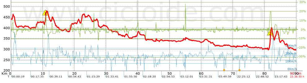
| Total Distance: 90.04 Km |
| Analysed distance: 90.04 Km |
| Linear distance: 59.64 Km |
| Cumulated positive ramps: 620.28 m |
list of points info |
| Cumulated negative ramps: 761.05 m | |
| Maximum height: 479.8 m | |
| Minimum height: 296.39 m | |
| Climbing Ratio: 3.69 % | |
| Descent ratio: 2.89 % | |
| Cumulated postive ramps per Km: 6.89 m | |
| Cumulated negative ramps per Km: 8.45 m | |
| Total time: 23:38:50 h |
| Time in movement: 4:56:37 h |
| According to your statistics Your time in motion would be: ? h
|
| Stopped time: 18:42:13 h |
| Maximum slope filter: ~30 % |
| Minimum separation analysed: ~30 m |
| Number of points: 1164 (cad. 77.35 m) |
| Significant waypoints: 979 (cad. 91.97 m / 84.11 %) |
| Changes in direction per Km: 4.73 |
| Changes in direction > 5� por Km: 3.91 |
| Cumulated straight stretches: 15.103 Km |
| Straight stretches per Km: 167.74 m |
| Penalized slope changes: 7 |
| Penalized slope changes per Km: 0.078 |
| Average speed in total: 3.81 Km/h |
| Average speed while moving: 18.21 Km/h |
| According to your statistics Your average speed would be: ? Km/h
|
| Maximum sustained speed: 47.94 Km/h |


