Giro Italia 2016 - Etapa 3- Nijmegen - Arnhem

Road
Road
Ref..: 315592
Published: 23/05/2016
Performed: 29/11/1999
Distance in Km: 177.9
Climb in m: 590
IBP: 114 BYC   Drawn route

Jose Maria
Author: Jose Maria
44 published routes

Add to my Group or Club


Varios dias

This route belongs to a multi-day journey 21 days documented with 21 independent routes

You can download the tracks of this multi-day route from each of the associated stages .
 Day or stage  One day stage  Distance  Climb in  IBP
 Day 1  338242 Giro Italia 2016 - Etapa 1- Apeldoorn - Apeldoorn  10 Km  19 m  2
 Day 2  315541 Giro Italia 2016 - Etapa 2- Arnhem - Nijmegen  178 Km  679 m  117
 Day 3  315592 Giro Italia 2016 - Etapa 3- Nijmegen - Arnhem (This)  178 Km  590 m  114
 Day 4  315650 Giro Italia 2016 - Etapa 4- Catanzaro - Praia a Mare  197 Km  2458 m  223
 Day 5  315661 Giro Italia 2016 - Etapa 5- Praia a Mare - Benevento  231 Km  4021 m  306
 Day 6  315662 Giro Italia 2016 - Etapa 6- Ponte - Roccaraso  166 Km  4306 m  301
 Day 7  315663 Giro d'Italia 2016 Etapa 7- 210 km Sulmona - Foligno  217 Km  2926 m  250
 Day 8  315680 Giro d'Italia 2016 Etapa 8 - 169 km Foligno - Arezzo  166 Km  2439 m  198
 Day 9  315720 Giro Italia 2016 - Etapa 9- Radda in Chianti - Greve in Chianti  39 Km  940 m  72
 Day 10  315743 Giro Italia 2016 - Etapa 10- Campi Bisenzio - Sestola  222 Km  5294 m  376
 Day 11  315776 Giro Italia 2016 - Etapa 11- Modena - Asolo  219 Km  576 m  153
 Day 12  315835 Giro Italia 2016 - Etapa 12- Noale - Bibione  173 Km  42 m  90
 Day 13  315868 Giro Italia 2016 - Etapa 13 - Palmanova - Cividale del Friuli  166 Km  3655 m  300
 Day 14  315942 Giro d'Italia 2016 - Etapa 14 - 210 km Alpago (Farra) - Corvara  218 Km  5747 m  376
 Day 15  315982 Giro Italia 2016 - Etapa 15- Castelrotto-Kastelruth - Alpe di Siusi-Seiseralm  11 Km  796 m  61
 Day 16  316062 Giro Italia 2016 - Etapa 16- Bressanone-Brixen - Andalo  138 Km  2845 m  195
 Day 17  316093 Giro Italia 2016 - Etapa 17- Molveno - Cassano d'Adda  205 Km  1476 m  168
 Day 18  316118 Giro Italia 2016 - Etapa 18- Muggiò - Pinerolo  244 Km  1540 m  228
 Day 19  316117 Giro Italia 2016 - Etapa 19- Pinerolo - Risoul  166 Km  3987 m  284
 Day 20  316162 Giro Italia 2016 - Etapa 20- Guillestre - Sant'Anna di Vinadio  135 Km  4783 m  331
 Day 21  338244 Giro Italia 2016 - Etapa 21- Cuneo - Torino  97 Km  195 m  40
 Total 21 days  3376 Km  49314 m  199 / día

 Height in m      Climb in %      Speed in Km/h      Speed < 2 Km/h


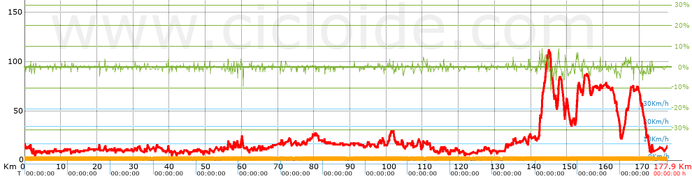
Description of the route


Presence of ramps


 Climbs  Distance  % of the total  Speed  Your speed would be  Time  Your time would be
   15 - 30%  0  0  0  ?  0:00:00  ?
   10 - 15%  0  0  0  ?  0:00:00  ?
   5 - 10%  1.635  0.92  0  ?  0:00:00  ?
   1 - 5%  22.458  12.62  0  ?  0:00:00  ?
   Total*  24.093 Km  13.54 %  0 Km/h  ? Km/h    0:00:00 h  ? h  
 Flat
   1 - -1%  127.666 Km  71.76 %  0 Km/h  ? Km/h    0:00:00 h  ? h  
 Descents
   -1 - -5%  24.69  13.88  0  ?  0:00:00  ?
   -5 - -10%  1.298  0.73  0  ?  0:00:00  ?
   -10 - -15%  0.154  0.09  0  ?  0:00:00  ?
   -15 - -30%  0  0  0  ?  0:00:00  ?
   Total*  26.142 Km  14.69 %  0 Km/h  ? Km/h    0:00:00 h  ? h  
* The total has not necessarily coincide with the sum of the partials after correction of errors

How long would it take you?

How long would it take you to cover this route?
There are routes without a valid time information, but with your average stats you can assess the possible duration

Jose Maria to cover this route you've need a time of:   --- h 
If you sign in and have a minimum of two tracks of this same modality, you can know your time for this route, calculated from your stats..


¿Cuanto consumirá tu E-BIKE?

Entra tu E-IBP (formato n,nn)

E-IBP :   X 114 = 


 Detected activity type =  ()
 Penalization due to track conditions: 18 %   ( > 50 % = MTB, < 50 % = RDB)
 Reliability of the track: C   (589/53/0/-/-/53)
 Correction level applied to the track: 0
DIFFICULTY OF THE ROUTE
IBP = 114 BYC
According to your statistics
 Your time in motion would be: ? h
Your average speed would be: ? Km/h
 

 Total Distance: 177.9 Km
 Analysed distance: 177.9 Km
 Linear distance: 14.91 Km

 Cumulated positive ramps: 590 m  list of points info
 Cumulated negative ramps: 610 m
 Maximum height: 111 m
 Minimum height: 5 m
 Climbing Ratio: 2.45 %
 Descent ratio: 2.33 %
 Cumulated postive ramps per Km: 3.32 m
 Cumulated negative ramps per Km: 3.43 m

 Total time: --- h
 Time in movement: --- h
 According to your statistics
 Your time in motion would be: ? h  
 Stopped time: --- h
 Maximum slope filter: ~30 %
 Minimum separation analysed: ~30 m
 Number of points: 2855   (cad. 62.31 m)
 Significant waypoints: 1852   (cad. 96.06 m / 64.87 %)

 Changes in direction per Km: 4.24
 Changes in direction > 5º por Km: 3.19
 Cumulated straight stretches: 33.59 Km
 Straight stretches per Km: 188.81 m
 Penalized slope changes: 3
 Penalized slope changes per Km: 0.017

 Average speed in total: 0 Km/h
 Average speed while moving: 0 Km/h
 According to your statistics
 Your average speed would be: ? Km/h  
 Maximum sustained speed: 0 Km/h


Comments

You can be the first one in commenting this route

 
My comments
:
Add comment  (Registered users)
 
Notify me answers to my comment  Do not notify answers to my comment


Share this route with a friend

Your friend will receive a message with a link to this page:
will see your email and your user name if you do it as registered user.


Write here your name (optional)

E-mail address of your friend(s). You can include various addresses separated by commas

Text or comment (optional) maximum 255 characters long, 255 Available characters

As a non registered users you need to fill-in the captcha text.
  Change image
Type the image characters.
 
 Share with a friend


Visited history

Delete history

Marked routes for review later or compare

My favorites


  Notify anomaly in this route Share in Facebook