Camino de Santiago (2015). Etapa 8. Soria-San Leonardo de Yagüe

MTB
MTB
Ref..: 29765
Published: 16/09/2015
Performed: 27/06/2015
Distance in Km: 68.26
Climb in m: 705
IBP: 61 BYC

Rodri63
Author: Rodri63
73 published routes

Add to my Group or Club


Varios dias

This route belongs to a multi-day journey 16 days documented with 16 independent routes

You can download the tracks of this multi-day route from each of the associated stages .
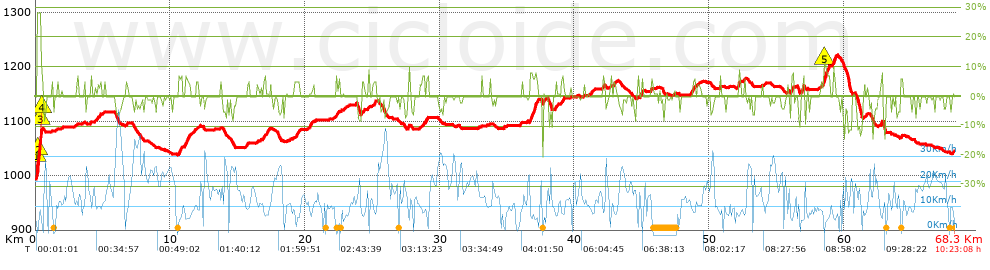
 Day or stage  One day stage  Distance  Climb in  IBP
 Day 1  29732 Camino de Santiago (2015). Etapa 1. Sant Joan Despí-Jorba  91 Km  1587 m  125
 Day 2  29741 Camino de Santiago (2015). Etapa 2. Jorba-Lleida  95 Km  673 m  73
 Day 3  29742 Camino de Santiago (2015). Etapa 3. Lleida-Bujaraloz  84 Km  815 m  80
 Day 4  29744 Camino de Santiago (2015). Etapa 4. Bujaraloz-Zaragoza  88 Km  282 m  47
 Day 5  29745 Camino de Santiago (2015). Etapa 5. Zaragoza-Borja  84 Km  450 m  55
 Day 6  29751 Camino de Santiago (2015). Etapa 6. Borja-Ágreda  61 Km  1230 m  99
 Day 7  29764 Camino de Santiago (2015). Etapa 7. Ágreda-Soria  63 Km  1095 m  88
 Day 8  29765 Camino de Santiago (2015). Etapa 8. Soria-San Leonardo de Yagüe (This)  68 Km  705 m  60
 Day 9  29766 Camino de Santiago (2015). Etapa 9 San Leonardo de Yagüe-Santo Domingo de Silos  76 Km  1006 m  93
 Day 10  29767 Camino de Santiago (2015). Etapa 10. Santo Domingo de Silos-Hornillos del Camino  87 Km  792 m  70
 Day 11  30361 Camino de Santiago (2015) Etapa 11. Hornillos del Camino-Calzadilla de la Cueza  85 Km  566 m  62
 Day 12  30363 Camino de Santiago (2015). Etapa 12. Calzadilla de la Cueza-León  80 Km  545 m  55
 Day 13  30364 Camino de Santiago (2015). Etapa 13: León-Rabanal del Camino  75 Km  747 m  60
 Day 14  30365 Camino de Santiago (2015). Etapa 14: Rabanal del Camino-Las Herrerías  78 Km  1140 m  92
 Day 15  30366 Camino de Santiago (2015). Etapa 15: Las Herrerías-Portomarín  80 Km  1842 m  144
 Day 16  30367 Camino de Santiago (2015). Etapa 16: Portomarín-Santiago de Compostela  94 Km  1754 m  132
 Total 16 days  1289 Km  15229 m  83 / día

 Height in m      Climb in %      Speed in Km/h      Speed < 2 Km/h


Description of the route


Presence of ramps


 Climbs  Distance  % of the total  Speed  Your speed would be  Time  Your time would be
   15 - 30%  0.298  0.44  8.33  ?  0:02:09  ?
   10 - 15%  0.378  0.55  5.44  ?  0:04:10  ?
   5 - 10%  5.956  8.73  7.2  ?  0:49:37  ?
   1 - 5%  7.078  10.37  9.52  ?  0:44:37  ?
   Total*  13.711 Km  20.09 %  8.18 Km/h  ? Km/h    1:40:33 h  ? h  
 Flat
   1 - -1%  39.914 Km  58.48 %  12.6 Km/h  ? Km/h    3:10:05 h  ? h  
 Descents
   -1 - -5%  8.911  13.06  22.2  ?  0:24:05  ?
   -5 - -10%  5.042  7.39  14.39  ?  0:21:01  ?
   -10 - -15%  0.623  0.91  10.84  ?  0:03:27  ?
   -15 - -30%  0.059  0.09  19.27  ?  0:00:11  ?
   Total*  14.635 Km  21.44 %  18.02 Km/h  ? Km/h    0:48:44 h  ? h  
* The total has not necessarily coincide with the sum of the partials after correction of errors

How long would it take you?

How long would it take you to cover this route?
There are routes without a valid time information, but with your average stats you can assess the possible duration

Rodri63 to cover this route you've need a time of:   5:39:22 h 
If you sign in and have a minimum of two tracks of this same modality, you can know your time for this route, calculated from your stats..


¿Cuanto consumirá tu E-BIKE?

Entra tu E-IBP (formato n,nn)

E-IBP :   X 61 = 


 Detected activity type =  ()
 Penalization due to track conditions: 49 %   ( > 50 % = MTB, < 50 % = RDB)
 Reliability of the track: A   (705/75/0/-/-/75)
 Correction level applied to the track: 0
DIFFICULTY OF THE ROUTE
IBP = 61 BYC
According to your statistics
 Your time in motion would be: ? h
Your average speed would be: ? Km/h
 

 Total Distance: 68.25 Km
 Analysed distance: 68.25 Km
 Linear distance: 50.58 Km

 Cumulated positive ramps: 705.16 m  list of points info
 Cumulated negative ramps: 652.2 m
 Maximum height: 1222 m
 Minimum height: 994.4 m
 Climbing Ratio: 5.14 %
 Descent ratio: 4.46 %
 Cumulated postive ramps per Km: 10.33 m
 Cumulated negative ramps per Km: 9.56 m

 Total time: 10:23:08 h
 Time in movement: 5:39:22 h
 According to your statistics
 Your time in motion would be: ? h  
 Stopped time: 4:43:46 h
 Maximum slope filter: ~30 %
 Minimum separation analysed: ~30 m
 Number of points: 6572   (cad. 10.39 m)
 Significant waypoints: 1757   (cad. 38.87 m / 26.73 %)

 Changes in direction per Km: 10.97
 Changes in direction > 5º por Km: 5.61
 Cumulated straight stretches: 22.418 Km
 Straight stretches per Km: 328.47 m
 Penalized slope changes: 7
 Penalized slope changes per Km: 0.103

 Average speed in total: 6.57 Km/h
 Average speed while moving: 12.07 Km/h
 According to your statistics
 Your average speed would be: ? Km/h  
 Maximum sustained speed: 50.09 Km/h


Comments

You can be the first one in commenting this route

 
My comments
:
Add comment  (Registered users)
 
Notify me answers to my comment  Do not notify answers to my comment


Share this route with a friend

Your friend will receive a message with a link to this page:
will see your email and your user name if you do it as registered user.


Write here your name (optional)

E-mail address of your friend(s). You can include various addresses separated by commas

Text or comment (optional) maximum 255 characters long, 255 Available characters

As a non registered users you need to fill-in the captcha text.
  Change image
Type the image characters.
 
 Share with a friend


Visited history

Delete history

Marked routes for review later or compare

My favorites


  Notify anomaly in this route Share in Facebook