Real-Tous-Bicorp-DosAguas-Real

Road
Road
Ref..: 133619
Published: 16/02/2016
Performed: 16/02/2016
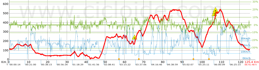
Distance in Km: 125.45
Climb in m: 1888
IBP: 139 BYC

delfinpascual
252 published routes

Add to my Group or Club

 Height in m      Climb in %      Speed in Km/h      Speed < 2 Km/h

Climbs > 5%

Climbs >5% Climbs >10% Climbs >15% Climbs >20% Climbs >25%
 Steep slope of 136 m.   Average slope  Distances  Download as waypoint
1
 Km 2.536  6%  136 m
 Steep slope of 96 m.  Average slope  Distances  Download as waypoint
2
 Km 21.677  7%  96 m
 Steep slope of 94 m.  Average slope  Distances  Download as waypoint
3
 Km 26.313  8%  94 m
 Steep slope of 94 m.  Average slope  Distances  Download as waypoint
4
 Km 32.335  6%  94 m
 Steep slope of 222 m.  Average slope  Distances  Download as waypoint
5
 Km 33.738  9%  222 m
 Steep slope of 104 m.  Average slope  Distances  Download as waypoint
6
 Km 37.631  5%  104 m
 Steep slope of 130 m.  Average slope  Distances  Download as waypoint
7
 Km 47.44  5%  130 m
 Steep slope of 104 m.  Average slope  Distances  Download as waypoint
8
 Km 47.664  6%  104 m
 Steep slope of 136 m.  Average slope  Distances  Download as waypoint
9
 Km 47.882  5%  136 m
 Steep slope of 387 m.  Average slope  Distances  Download as waypoint
10
 Km 48.194  7%  387 m
 Steep slope of 1177 m.  Average slope  Distances  Download as waypoint
11
 Km 48.716  7%  1177 m
 Steep slope of 467 m.  Average slope  Distances  Download as waypoint
12
 Km 49.995  7%  467 m
 Steep slope of 93 m.  Average slope  Distances  Download as waypoint
13
 Km 50.553  6%  93 m
 Steep slope of 129 m.  Average slope  Distances  Download as waypoint
14
 Km 55.315  6%  129 m
 Steep slope of 253 m.  Average slope  Distances  Download as waypoint
15
 Km 55.567  5%  253 m
 Steep slope of 315 m.  Average slope  Distances  Download as waypoint
16
 Km 59.13  9%  315 m
 Steep slope of 287 m.  Average slope  Distances  Download as waypoint
17
 Km 60.53  7%  287 m
 Steep slope of 218 m.  Average slope  Distances  Download as waypoint
18
 Km 63.802  8%  218 m
 Steep slope of 769 m.  Average slope  Distances  Download as waypoint
19
 Km 65.26  8%  46 m
20
 Km 65.306  11%  95 m
21
 Km 65.401  8%  628 m
 Steep slope of 275 m.  Average slope  Distances  Download as waypoint
22
 Km 66.154  7%  275 m
 Steep slope of 124 m.  Average slope  Distances  Download as waypoint
23
 Km 66.522  8%  124 m
 Steep slope of 284 m.  Average slope  Distances  Download as waypoint
24
 Km 69.581  6%  284 m
 Steep slope of 253 m.  Average slope  Distances  Download as waypoint
25
 Km 70.21  8%  253 m
 Steep slope of 94 m.  Average slope  Distances  Download as waypoint
26
 Km 70.849  6%  94 m
 Steep slope of 308 m.  Average slope  Distances  Download as waypoint
27
 Km 71.056  7%  308 m
 Steep slope of 453 m.  Average slope  Distances  Download as waypoint
28
 Km 71.473  7%  453 m
 Steep slope of 197 m.  Average slope  Distances  Download as waypoint
29
 Km 72.025  7%  197 m
 Steep slope of 494 m.  Average slope  Distances  Download as waypoint
30
 Km 72.36  6%  494 m
 Steep slope of 218 m.  Average slope  Distances  Download as waypoint
31
 Km 73.268  7%  218 m
 Steep slope of 457 m.  Average slope  Distances  Download as waypoint
32
 Km 75.323  7%  457 m
 Steep slope of 128 m.  Average slope  Distances  Download as waypoint
33
 Km 78.507  6%  128 m
 Steep slope of 198 m.  Average slope  Distances  Download as waypoint
34
 Km 78.783  6%  198 m
 Steep slope of 158 m.  Average slope  Distances  Download as waypoint
35
 Km 79.071  6%  158 m
 Steep slope of 259 m.  Average slope  Distances  Download as waypoint
36
 Km 79.724  7%  259 m
 Steep slope of 259 m.  Average slope  Distances  Download as waypoint
37
 Km 80.147  5%  259 m
 Steep slope of 227 m.  Average slope  Distances  Download as waypoint
38
 Km 80.526  7%  227 m
 Steep slope of 121 m.  Average slope  Distances  Download as waypoint
39
 Km 82.419  5%  121 m
 Steep slope of 440 m.  Average slope  Distances  Download as waypoint
40
 Km 82.641  7%  440 m
 Steep slope of 620 m.  Average slope  Distances  Download as waypoint
41
 Km 83.189  7%  620 m
 Steep slope of 123 m.  Average slope  Distances  Download as waypoint
42
 Km 84.585  7%  123 m
 Steep slope of 97 m.  Average slope  Distances  Download as waypoint
43
 Km 85.112  5%  97 m
 Steep slope of 128 m.  Average slope  Distances  Download as waypoint
44
 Km 97.9  8%  128 m
 Steep slope of 213 m.  Average slope  Distances  Download as waypoint
45
 Km 100.56  6%  213 m
 Steep slope of 285 m.  Average slope  Distances  Download as waypoint
46
 Km 100.897  6%  285 m
 Steep slope of 109 m.  Average slope  Distances  Download as waypoint
47
 Km 101.37  5%  109 m
 Steep slope of 150 m.  Average slope  Distances  Download as waypoint
48
 Km 101.574  5%  150 m
 Steep slope of 800 m.  Average slope  Distances  Download as waypoint
49
 Km 101.862  7%  800 m
 Steep slope of 298 m.  Average slope  Distances  Download as waypoint
50
 Km 103.04  7%  298 m
 Steep slope of 329 m.  Average slope  Distances  Download as waypoint
51
 Km 103.435  6%  329 m
 Steep slope of 124 m.  Average slope  Distances  Download as waypoint
52
 Km 105.213  8%  124 m
 Steep slope of 313 m.  Average slope  Distances  Download as waypoint
53
 Km 105.755  6%  313 m
 Steep slope of 301 m.  Average slope  Distances  Download as waypoint
54
 Km 106.788  9%  92 m
55
 Km 106.88  10%  96 m
56
 Km 106.976  5%  113 m
 Steep slope of 737 m.  Average slope  Distances  Download as waypoint
57
 Km 107.182  6%  75 m
58
 Km 107.258  10%  96 m
59
 Km 107.354  8%  121 m
60
 Km 107.475  11%  100 m
61
 Km 107.575  9%  345 m
 Steep slope of 98 m.  Average slope  Distances  Download as waypoint
62
 Km 109.375  7%  98 m
 Steep slope of 96 m.  Average slope  Distances  Download as waypoint
63
 Km 109.776  7%  96 m
 Steep slope of 351 m.  Average slope  Distances  Download as waypoint
64
 Km 113.443  6%  351 m
 Steep slope of 325 m.  Average slope  Distances  Download as waypoint
65
 Km 113.904  6%  325 m


Description of the route


Presence of ramps


 Climbs  Distance  % of the total  Speed  Your speed would be  Time  Your time would be
   15 - 30%  0  0  0  ?  0:00:00  ?
   10 - 15%  1.912  1.52  10.32  ?  0:11:07  ?
   5 - 10%  17.175  13.69  11.95  ?  1:26:12  ?
   1 - 5%  16.063  12.8  16.65  ?  0:57:53  ?
   Total*  35.15 Km  28.02 %  13.59 Km/h  ? Km/h    2:35:12 h  ? h  
 Flat
   1 - -1%  50.767 Km  40.47 %  24.32 Km/h  ? Km/h    2:05:15 h  ? h  
 Descents
   -1 - -5%  22.71  18.1  35.65  ?  0:38:13  ?
   -5 - -10%  15.942  12.71  38.83  ?  0:24:38  ?
   -10 - -15%  0.875  0.7  27.39  ?  0:01:55  ?
   -15 - -30%  0  0  0  ?  0:00:00  ?
   Total*  39.527 Km  31.51 %  36.62 Km/h  ? Km/h    1:04:46 h  ? h  
* The total has not necessarily coincide with the sum of the partials after correction of errors

How long would it take you?

How long would it take you to cover this route?
There are routes without a valid time information, but with your average stats you can assess the possible duration

delfinpascual to cover this route you've need a time of:   5:45:13 h 
If you sign in and have a minimum of two tracks of this same modality, you can know your time for this route, calculated from your stats..


¿Cuanto consumirá tu E-BIKE?

Entra tu E-IBP (formato n,nn)

E-IBP :   X 139 = 


 Detected activity type =  ()
 Penalization due to track conditions: 46 %   ( > 50 % = MTB, < 50 % = RDB)
 Reliability of the track: A   (1888/87/0/-/-/87)
 Correction level applied to the track: 0
DIFFICULTY OF THE ROUTE
IBP = 139 BYC
According to your statistics
 Your time in motion would be: ? h
Your average speed would be: ? Km/h
 

 Total Distance: 125.44 Km
 Analysed distance: 125.44 Km
 Linear distance: 0.04 Km

 Cumulated positive ramps: 1888.2 m  list of points info
 Cumulated negative ramps: 1880.8 m
 Maximum height: 543 m
 Minimum height: 9.4 m
 Climbing Ratio: 5.37 %
 Descent ratio: 4.76 %
 Cumulated postive ramps per Km: 15.05 m
 Cumulated negative ramps per Km: 14.99 m

 Total time: 6:41:48 h
 Time in movement: 5:45:13 h
 According to your statistics
 Your time in motion would be: ? h  
 Stopped time: 0:56:35 h
 Maximum slope filter: ~30 %
 Minimum separation analysed: ~30 m
 Number of points: 10314   (cad. 12.16 m)
 Significant waypoints: 3136   (cad. 40 m / 30.41 %)

 Changes in direction per Km: 8.02
 Changes in direction > 5º por Km: 4.93
 Cumulated straight stretches: 44.45 Km
 Straight stretches per Km: 354.35 m
 Penalized slope changes: 21
 Penalized slope changes per Km: 0.167

 Average speed in total: 18.73 Km/h
 Average speed while moving: 21.8 Km/h
 According to your statistics
 Your average speed would be: ? Km/h  
 Maximum sustained speed: 59.24 Km/h


Comments

You can be the first one in commenting this route

 
My comments
:
Add comment  (Registered users)
 
Notify me answers to my comment  Do not notify answers to my comment


Share this route with a friend

Your friend will receive a message with a link to this page:
will see your email and your user name if you do it as registered user.


Write here your name (optional)

E-mail address of your friend(s). You can include various addresses separated by commas

Text or comment (optional) maximum 255 characters long, 255 Available characters

As a non registered users you need to fill-in the captcha text.
  Change image
Type the image characters.
 
 Share with a friend


Visited history

Delete history

Marked routes for review later or compare

My favorites


  Notify anomaly in this route Share in Facebook